Report on Heard (Australia) — 26 November-2 December 2014
Smithsonian Institution / US Geological Survey
Weekly Volcanic Activity Report, 26 November-2 December 2014
Managing Editor: Sally Sennert.
Please cite this report as:
Global Volcanism Program, 2014. Report on Heard (Australia) (Sennert, S, ed.). Weekly Volcanic Activity Report, 26 November-2 December 2014. Smithsonian Institution and US Geological Survey.
Heard
Australia
53.106°S, 73.513°E; summit elev. 2745 m
All times are local (unless otherwise noted)
According to a NOAA National Environmental Satellite, Data, and Information Service (NESDIS) scientist, thermal anomalies seemingly on the E flank of Heard were detected in Visible Infrared Imaging Radiometer Suite (VIIRS) satellite images during 2-30 November. Dense cloud cover prevented views of the volcano during 1-2 December. MODIS (Moderate Resolution Imaging Spectroradiometer) images had detected thermal anomalies from September [2013] to 21 July 2014, and again on 16 November 2014, due to a persisting lava lake and possible lava flows.
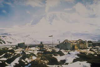
Geological Summary. Heard Island on the Kerguelen Plateau in the southern Indian Ocean consists primarily of the emergent portion of two volcanic structures. The large glacier-covered composite basaltic-to-trachytic cone of Big Ben comprises most of the island, and the smaller Mt. Dixon lies at the NW tip of the island across a narrow isthmus. Little is known about the structure of Big Ben because of its extensive ice cover. The active Mawson Peak forms the island's high point and lies within a 5-6 km wide caldera breached to the SW side of Big Ben. Small satellitic scoria cones are mostly located on the northern coast. Several subglacial eruptions have been reported at this isolated volcano, but observations are infrequent and additional activity may have occurred.
Sources: Michael J. Pavolonis (NOAA/NESDIS), personal communication, NASA MODIS Rapid Response System

