Report on Bogoslof (United States) — 15 March-21 March 2017
Smithsonian Institution / US Geological Survey
Weekly Volcanic Activity Report, 15 March-21 March 2017
Managing Editor: Sally Sennert.
Please cite this report as:
Global Volcanism Program, 2017. Report on Bogoslof (United States) (Sennert, S, ed.). Weekly Volcanic Activity Report, 15 March-21 March 2017. Smithsonian Institution and US Geological Survey.
Bogoslof
United States
53.93°N, 168.03°W; summit elev. 150 m
All times are local (unless otherwise noted)
AVO reported that no significant volcanic activity at Bogoslof was detected in seismic or infrasound data during 15-21 March, and satellite views were either obscured by clouds or showed nothing noteworthy. Slightly elevated surface temperatures were identified in satellite images during 16-17 and 20-21 March. The Aviation Color Code remained at Orange and the Volcano Alert Level remained at Warning.
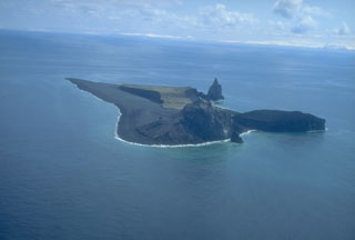
Geological Summary. Bogoslof is the emergent summit of a submarine volcano that lies 40 km N of the main Aleutian arc. It rises 1,500 m above the Bering Sea floor. Repeated construction and destruction of lava domes at different locations during historical time has greatly modified the appearance of this "Jack-in-the-Box" volcano and has introduced a confusing nomenclature applied during frequent visits by exploring expeditions. The present triangular-shaped, 0.75 x 2 km island consists of remnants of lava domes emplaced from 1796 to 1992. Castle Rock (Old Bogoslof) is a steep-sided pinnacle that is a remnant of a spine from the 1796 eruption. The small Fire Island (New Bogoslof), about 600 m NW of Bogoslof Island, is a remnant of a lava dome formed in 1883.
Source: US Geological Survey Alaska Volcano Observatory (AVO)

