Report on Lopevi (Vanuatu) — 13 December-19 December 2017
Smithsonian Institution / US Geological Survey
Weekly Volcanic Activity Report, 13 December-19 December 2017
Managing Editor: Sally Sennert.
Please cite this report as:
Global Volcanism Program, 2017. Report on Lopevi (Vanuatu) (Sennert, S, ed.). Weekly Volcanic Activity Report, 13 December-19 December 2017. Smithsonian Institution and US Geological Survey.
Lopevi
Vanuatu
16.507°S, 168.346°E; summit elev. 1413 m
All times are local (unless otherwise noted)
The Wellington VAAC noted that on 20 December a low-level eruption plume from Lopevi was visible in satellite and webcam images drifting NW at an altitude of 1.5 km (5,000 ft) a.s.l.
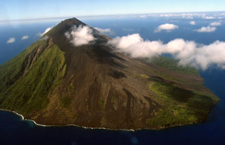
Geological Summary. The small 7-km-wide conical island of Lopevi, known locally as Vanei Vollohulu, is one of Vanuatu's most active volcanoes. A small summit crater containing a cinder cone is breached to the NW and tops an older cone that is rimmed by the remnant of a larger crater. The basaltic-to-andesitic volcano has been active during historical time at both summit and flank vents, primarily along a NW-SE-trending fissure that cuts across the island, producing moderate explosive eruptions and lava flows that reached the coast. Historical eruptions at the 1413-m-high volcano date back to the mid-19th century. The island was evacuated following major eruptions in 1939 and 1960. The latter eruption, from a NW-flank fissure vent, produced a pyroclastic flow that swept to the sea and a lava flow that formed a new peninsula on the western coast.

