Report on Zaozan [Zaosan] (Japan) — 24 January-30 January 2018
Smithsonian Institution / US Geological Survey
Weekly Volcanic Activity Report, 24 January-30 January 2018
Managing Editor: Sally Sennert.
Please cite this report as:
Global Volcanism Program, 2018. Report on Zaozan [Zaosan] (Japan) (Sennert, S, ed.). Weekly Volcanic Activity Report, 24 January-30 January 2018. Smithsonian Institution and US Geological Survey.
Zaozan [Zaosan]
Japan
38.144°N, 140.44°E; summit elev. 1841 m
All times are local (unless otherwise noted)
JMA reported that tremor was detected at Zaozan on 28 and 30 January, and minor inflation at the S part of the volcano was recorded. There were 12 volcanic earthquakes detected on 31 January. JMA raised the Alert level to 2 (on a 5-level scale), noting the increased potential for a small eruption.
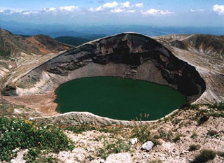
Geological Summary. The Zaozan (or Zaosan) volcano group consists of a complex cluster of stratovolcanoes in north-central Honshu about 40 km W of Sendai Bay. The Pleistocene Ryuzan volcano forms the western group (Nishi-Zao), and Byobu and Fubo volcanoes form the southern group (Minami-Zao). The complex was constructed over granitic basement rocks thus has a relatively small volume. The 7 km3 Zaozan volcano proper forms the central group (Chuo-Zao), a complex topped by several lava domes and the Goshikidake tuff cone, aligned NW-SE. Several episodes of edifice collapse produced debris avalanches during the Pleistocene. Goshikidake contains the active Okama crater, filled with a colorful, strongly acidic crater lake; it has been the source of most of the frequent eruptions recorded since the 8th century CE.

