Report on Azumayama (Japan) — 15 May-21 May 2019
Smithsonian Institution / US Geological Survey
Weekly Volcanic Activity Report, 15 May-21 May 2019
Managing Editor: Sally Sennert.
Please cite this report as:
Global Volcanism Program, 2019. Report on Azumayama (Japan) (Sennert, S, ed.). Weekly Volcanic Activity Report, 15 May-21 May 2019. Smithsonian Institution and US Geological Survey.
Azumayama
Japan
37.735°N, 140.244°E; summit elev. 1949 m
All times are local (unless otherwise noted)
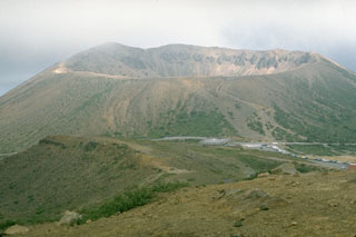
The number of volcanic earthquakes at Azumayama increased on 5 May and data from a tiltmeter about 1 km SE of Ohana Crater showed inflation on 9 May, prompting JMA to raise the Alert Level to 2 (on a 5-level scale). Field observations on 7 and 10 May indicated no changes in the fumarolic and thermal areas around Ohana. Seismicity began to decrease on 10 May, though continued to fluctuate through 20 May. Deformation continued but at a slower rate.
Geological Summary. The Azumayama volcanic group consists of a cluster of stratovolcanoes, shield volcanoes, lava domes, and pyroclastic cones. The andesitic and basaltic complex was constructed in two E-W rows above a relatively high basement of Tertiary sedimentary rocks and granodiorites west of Fukushima city. Volcanic activity has migrated to the east, with the Higashi-Azuma volcano group being the youngest. The symmetrical Azuma-Kofuji crater and a nearby fumarolic area on the flank of Issaikyo volcano are popular tourist destinations. The Azumayama complex contains several crater lakes, including Goshikinuma and Okenuma. Historical eruptions, mostly small phreatic explosions, have been restricted to Issaikyo volcano at the northern end of the Higashiyama group.

