Report on Fernandina (Ecuador) — 8 January-14 January 2020
Smithsonian Institution / US Geological Survey
Weekly Volcanic Activity Report, 8 January-14 January 2020
Managing Editor: Sally Sennert.
Please cite this report as:
Global Volcanism Program, 2020. Report on Fernandina (Ecuador) (Sennert, S, ed.). Weekly Volcanic Activity Report, 8 January-14 January 2020. Smithsonian Institution and US Geological Survey.
Fernandina
Ecuador
0.37°S, 91.55°W; summit elev. 1476 m
All times are local (unless otherwise noted)
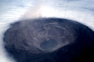
IG reported that a M 4.7 earthquake was recorded at 1642 on 12 January at Fernandina and followed by a swarm of 29 local earthquakes all below M 3.1. A new eruption began just before 1810 from a circumferential fissure located near the E edge of the caldera, at elevations around 1300-1400 m above sea level. Several lava flows descended the E flank; Galapagos National Park rangers witnessed the eruption from the Bolívar Channel station. A gas cloud rose 1.5-2 km above the fissure and drifted WNW. A second peak in seismicity was recorded 30-40 minutes after the eruption onset and then gradually decreased. Gas emissions decreased sometime after 2100 and thermal anomalies began to gradually diminish.
Geological Summary. Fernandina, the most active of Galápagos volcanoes and the one closest to the Galápagos mantle plume, is a basaltic shield volcano with a deep 5 x 6.5 km summit caldera. The volcano displays the classic "overturned soup bowl" profile of Galápagos shield volcanoes. Its caldera is elongated in a NW-SE direction and formed during several episodes of collapse. Circumferential fissures surround the caldera and were instrumental in growth of the volcano. Reporting has been poor in this uninhabited western end of the archipelago, and even a 1981 eruption was not witnessed at the time. In 1968 the caldera floor dropped 350 m following a major explosive eruption. Subsequent eruptions, mostly from vents located on or near the caldera boundary faults, have produced lava flows inside the caldera as well as those in 1995 that reached the coast from a SW-flank vent. Collapse of a nearly 1 km3 section of the east caldera wall during an eruption in 1988 produced a debris-avalanche deposit that covered much of the caldera floor and absorbed the caldera lake.
Source: Instituto Geofísico-Escuela Politécnica Nacional (IG-EPN)

