Report on Taal (Philippines) — 15 January-21 January 2020
Smithsonian Institution / US Geological Survey
Weekly Volcanic Activity Report, 15 January-21 January 2020
Managing Editor: Sally Sennert.
Please cite this report as:
Global Volcanism Program, 2020. Report on Taal (Philippines) (Sennert, S, ed.). Weekly Volcanic Activity Report, 15 January-21 January 2020. Smithsonian Institution and US Geological Survey.
Taal
Philippines
14.0106°N, 120.9975°E; summit elev. 311 m
All times are local (unless otherwise noted)
PHIVOLCS reported that the eruption at Taal continued during 14-21 January, though was generally weaker. Activity during 15-16 January was characterized by dark gray, steam-laden plumes that rose as high as 1 km above the vents in Main Crater and drifted S and SW. Satellite images showed that the Main Crater lake was gone, and new craters had formed on the floor and N flank of Volcano Island. Sulfur dioxide emissions were 4,186 tonnes per day on 15 January. Eruptive events at 0617 and 0621 on 16 January generated short-lived, dark gray ash plumes that rose 500 and 800 m, respectively, and drifted SW. Weak steam plumes rose 800 m and drifted SW during 1100-1700, and nine weak explosions were recorded by the seismic network. Dropping water levels of Taal Lake were first observed in some areas on 16 January but reported to be lake-wide the next day. The known ground cracks in the barangays of Lemery, Agoncillo, Talisay, and San Nicolas in Batangas Province widened a few centimeters by 17 January, and a new steaming fissure was identified on the N flank of the island.
Steady steam emissions were visible during 17-21 January. Infrequent weak explosions generated ash plumes that rose as high as 1 km and drifted SW. Sulfur dioxide emissions fluctuated and were as high as 4,353 tonnes per day on 20 January and as low as 344 tonnes per day on 21 January. From 1300 on 12 January to 0800 on 21 January the Philippine Seismic Network (PSN) had recorded a total of 718 volcanic earthquakes; 176 of those had magnitudes ranging from 1.2-4.1 and were felt with Intensities of I-V. During 20-21 January there were five volcanic earthquakes with magnitudes of 1.6-2.5; the Taal Volcano network (which can detect smaller events not detectable by the PSN) recorded 448 volcanic earthquakes, including 17 low-frequency events. According to the Disaster Response Operations Monitoring and Information Center (DROMIC) there were a total of 148,987 people in 493 evacuation centers as of 1800 on 21 January. The Alert Level remained at 4 (on a scale of 0-5).
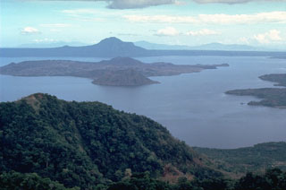
Geological Summary. Taal is one of the most active volcanoes in the Philippines and has produced some powerful eruptions. The 15 x 20 km Talisay (Taal) caldera is largely filled by Lake Taal, whose 267 km2 surface lies only 3 m above sea level. The maximum depth of the lake is 160 m, with several submerged eruptive centers. The 5-km-wide Volcano Island in north-central Lake Taal is the location of all observed eruptions. The island is composed of coalescing small stratovolcanoes, tuff rings, and scoria cones. Powerful pyroclastic flows and surges have caused many fatalities.
Sources: Philippine Institute of Volcanology and Seismology (PHIVOLCS), Disaster Response Operations Monitoring and Information Center (DROMIC)

