Report on Raung (Indonesia) — 5 August-11 August 2020
Smithsonian Institution / US Geological Survey
Weekly Volcanic Activity Report, 5 August-11 August 2020
Managing Editor: Sally Sennert.
Please cite this report as:
Global Volcanism Program, 2020. Report on Raung (Indonesia) (Sennert, S, ed.). Weekly Volcanic Activity Report, 5 August-11 August 2020. Smithsonian Institution and US Geological Survey.
Raung
Indonesia
8.119°S, 114.056°E; summit elev. 3260 m
All times are local (unless otherwise noted)
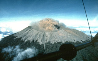
PVMBG reported that an eruptive event at Raung was detected on 1 August, though weather conditions prevented visual confirmation. Weather conditions continued to obscure of views of the volcano during 5-11 August; white plumes were visible rising 100-200 m above the summit during some of the breaks in cloud cover. The Alert Level remained at 2 (on a scale of 1-4), and the public was warned to remain outside of the 2-km exclusion zone.
Geological Summary. Raung, one of Java's most active volcanoes, is a massive stratovolcano in easternmost Java that was constructed SW of the rim of Ijen caldera. The unvegetated summit is truncated by a dramatic steep-walled, 2-km-wide caldera that has been the site of frequent historical eruptions. A prehistoric collapse of Gunung Gadung on the W flank produced a large debris avalanche that traveled 79 km, reaching nearly to the Indian Ocean. Raung contains several centers constructed along a NE-SW line, with Gunung Suket and Gunung Gadung stratovolcanoes being located to the NE and W, respectively.
Source: Pusat Vulkanologi dan Mitigasi Bencana Geologi (PVMBG, also known as CVGHM)

