Report on Cotopaxi (Ecuador) — 26 October-1 November 2022
Smithsonian Institution / US Geological Survey
Weekly Volcanic Activity Report, 26 October-1 November 2022
Managing Editor: Sally Sennert.
Please cite this report as:
Global Volcanism Program, 2022. Report on Cotopaxi (Ecuador) (Sennert, S, ed.). Weekly Volcanic Activity Report, 26 October-1 November 2022. Smithsonian Institution and US Geological Survey.
Cotopaxi
Ecuador
0.677°S, 78.436°W; summit elev. 5911 m
All times are local (unless otherwise noted)
IG issued a report that included data analysis and additional information about the minor eruptive activity at Cotopaxi recorded during 21-22 October. The eruption began with a high-frequency earthquake recorded at 1944 on 21 October and was followed by an episode of volcanic tremor from 1950 on 21 October to 0040 on 22 October. A diffuse gas-and-ash cloud rose 1.7-2.3 km above the summit and drifted NE. Ashfall was reported in the José Rivas Refuge for climbers on the N flank. Parque Nacional Cotopaxi closed to visitors due to the emissions. A small thermal anomaly in the summit crater was identified in satellite images on 23 October; a small anomaly had been repeatedly visible since the previous eruption during August-November 2015, though it had been absent since 12 November 2020.
On 22 October scientists measured sulfur dioxide emissions using a mobile Differential Optical Absorption Spectroscopy (DOAS) instrument in an area spanning near the W entrance to Parque Nacional Cotopaxi to areas in the park. They measured higher values, 1,580 tons per day, nearer to the volcano. Analysis of ash samples collected by IG scientists at the José Rivas Refuge revealed that about 22 percent was juvenile material, indicating a magmatic component to the eruption.
Parque Nacional Cotopaxi reopened on 26 October. Seismicity was at moderate levels that same day with the number of events per day progressively decreasing according to a news report. During an overflight of the summit crater on 27 October, scientists observed gas-and-steam emissions rising 500 m above the carter rim, obscuring views into the crater.
The amplitude of the tremor signal on 21 October was about half of that recorded during the 2015 eruption and the tremor signal only lasted about four hours whereas in 2015 some periods lasted several days. There was no notable precursory activity including anomalous seismic activity and deformation detected in satellite or GPS data. The Washington VAAC had previously reported ash emissions on 4 July 2016, 23 January 2017, 15 July 2018, and 10 January 2020, though none were associated with increased seismicity or ashfall. Climbers had previously reported ashfall on occasion, with the last report on 27 November 2021. Servicio Nacional de Gestión de Riesgos y Emergencias (SNGRE) maintained the Alert Level at Yellow (the second lowest level on a four-color scale).
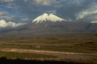
Geological Summary. The symmetrical, glacier-covered, Cotopaxi stratovolcano is Ecuador's most well-known volcano and one of its most active. The steep-sided cone is capped by nested summit craters, the largest of which is about 550 x 800 m in diameter. Deep valleys scoured by lahars radiate from the summit of the andesitic volcano, and large andesitic lava flows extend to its base. The modern edifice has been constructed since a major collapse sometime prior to about 5,000 years ago. Pyroclastic flows (often confused in historical accounts with lava flows) have accompanied many explosive eruptions, and lahars have frequently devastated adjacent valleys. Strong eruptions took place in 1744, 1768, and 1877. Pyroclastic flows descended all sides of the volcano in 1877, and lahars traveled more than 100 km into the Pacific Ocean and western Amazon basin. Smaller eruptions have been frequent since that time.
Sources: Instituto Geofísico-Escuela Politécnica Nacional (IG-EPN), Servicio Nacional de Gestión de Riesgos y Emergencias (SNGRE), El Comercio

