Report on Cotopaxi (Ecuador) — 22 May-28 May 2024
Smithsonian Institution / US Geological Survey
Weekly Volcanic Activity Report, 22 May-28 May 2024
Managing Editor: Sally Sennert.
Please cite this report as:
Global Volcanism Program, 2024. Report on Cotopaxi (Ecuador) (Sennert, S, ed.). Weekly Volcanic Activity Report, 22 May-28 May 2024. Smithsonian Institution and US Geological Survey.
Cotopaxi
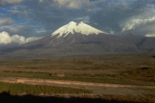
Ecuador
0.677°S, 78.436°W; summit elev. 5911 m
All times are local (unless otherwise noted)
IG-EPN reported that monitoring instruments began recording signals at 1510 on 23 May indicating that a moderately-sized secondary lahar was descending Cotopaxi’s NW flank. The public was advised to stay away from stream and river drainages within the vicinity of Parque Nacional Cotopaxi (Cotopaxi National Park).
Geological Summary. The symmetrical, glacier-covered, Cotopaxi stratovolcano is Ecuador's most well-known volcano and one of its most active. The steep-sided cone is capped by nested summit craters, the largest of which is about 550 x 800 m in diameter. Deep valleys scoured by lahars radiate from the summit of the andesitic volcano, and large andesitic lava flows extend to its base. The modern edifice has been constructed since a major collapse sometime prior to about 5,000 years ago. Pyroclastic flows (often confused in historical accounts with lava flows) have accompanied many explosive eruptions, and lahars have frequently devastated adjacent valleys. Strong eruptions took place in 1744, 1768, and 1877. Pyroclastic flows descended all sides of the volcano in 1877, and lahars traveled more than 100 km into the Pacific Ocean and western Amazon basin. Smaller eruptions have been frequent since that time.
Source: Instituto Geofísico-Escuela Politécnica Nacional (IG-EPN)