Report on Ahyi (United States) — 13 November-19 November 2024
Smithsonian Institution / US Geological Survey
Weekly Volcanic Activity Report, 13 November-19 November 2024
Managing Editor: Sally Sennert.
Please cite this report as:
Global Volcanism Program, 2024. Report on Ahyi (United States) (Sennert, S, ed.). Weekly Volcanic Activity Report, 13 November-19 November 2024. Smithsonian Institution and US Geological Survey.
Ahyi
United States
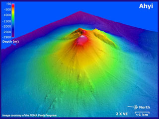
20.42°N, 145.03°E; summit elev. -75 m
All times are local (unless otherwise noted)
On 20 November the Aviation Color Code for Ahyi Seamount was raised to Yellow (the second lowest level on a four-color scale) and the Volcano Alert Level was raised to Advisory (the second lowest level on a four-level scale) due to an ongoing submarine eruption. Plumes of discolored water were observed extending as far as several hundred meters away from the volcano in satellite images on 1, 10, and 19 November. Retrospective analysis of older satellite data revealed minor activity extending back to 5 August. Possible pumice floating on the ocean surface was identified in the most recent image. No volcanic activity was identified in data from underwater pressure sensors near Wake Island (about 2,270 km E of Ahyi), though submarine plumes had been observed in the past without clear hydroacoustic signals.
Geological Summary. Ahyi seamount is a large conical submarine volcano that rises to within 75 m of the ocean surface ~18 km SE of the island of Farallon de Pajaros in the northern Marianas. Water discoloration has been observed there, and in 1979 the crew of a fishing boat felt shocks over the summit area, followed by upwelling of sulfur-bearing water. On 24-25 April 2001 an explosive eruption was detected seismically by a station on Rangiroa Atoll, Tuamotu Archipelago. The event was well constrained (+/- 15 km) at a location near the southern base of Ahyi. An eruption in April-May 2014 was detected by NOAA divers, hydroacoustic sensors, and seismic stations.
Source: US Geological Survey