Report on Kilauea (United States) — 5 March-11 March 2025
Smithsonian Institution / US Geological Survey
Weekly Volcanic Activity Report, 5 March-11 March 2025
Managing Editor: Sally Sennert.
Please cite this report as:
Global Volcanism Program, 2025. Report on Kilauea (United States) (Sennert, S, ed.). Weekly Volcanic Activity Report, 5 March-11 March 2025. Smithsonian Institution and US Geological Survey.
Kilauea
United States
19.421°N, 155.287°W; summit elev. 1222 m
All times are local (unless otherwise noted)
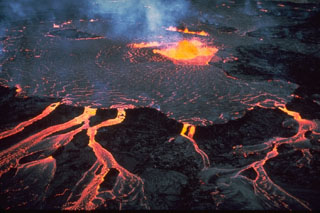
The Hawaiian Volcano Observatory (HVO) reported that the eruption within Kilauea’s Kaluapele summit caldera, from vents along the SW margin of Halema’uma’u Crater, continued at variable levels during 4-11 March. Lava fountaining and lava flow effusion from cones at both the N and S vents began around 0730 on 4 March and continued at variable levels through the day. Lava fountains at the N vent were rising over 100 m by 1430. At around the same time low dome fountains began rising from the S vent and lava flows advanced onto the crater floor. The fountains started to grow taller by 1500 and by 1520 they were 100-130 m tall, the same height as fountains at the N vent. Fountains at the S vent continued to rise and approached 180 m tall, while fountains at the N vent decreased in height. In addition to the activity at the N and S vents, small breakouts were visible on the rootless flows near the September 2023 vents on the down-dropped block in the E part of Halema’uma’u. Fountaining at the N vent ceased at 2026. Fountains at the S vent dropped to 90-120 m and continued to be active overnight. The N vent produced occasional bursts of spatter. Sustained lava fountains at the S vent decreased to 30-60 m during 0300-0430 on 5 March. Fountaining at the S vent increased at around 0800, and the N vent briefly resumed fountaining and erupting lava flows during 0842-0911. Lava flows covered more than two thirds of the crater floor. Activity at both vents ceased by 1030. Sulfur dioxide emission averaged approximately 35,000 tonnes per day (t/d) during the period of high fountaining on the afternoon of 4 March, then decreased to 20,000 t/d during lower fountaining on the morning of 5 March, and to 1,800 t/d by the afternoon. The flows from the N and S vents were active during 5-6 March with ooze outs and small crustal overturns, but the activity had ceased by the morning of 7 March. Sulfur dioxide emission averaged 1,000 t/d on 7 March.
Incandescence from both the N and S vents was visible during 8-10 March. At about 0130 on 10 March small, sporadic, spatter fountains at the N vent rose 5-10 m high and continued to intensify until 1835. Spattering was visible overnight. Lava flows emerged from the N vent at 0236 on 11 March and tall fountaining started 10 minutes later. By 0330 the fountains were 120-150 m tall and lava covered up to one-third of the crater floor. Lava flows unrelated to the activity at the N and S vents continued to spread out on the down-dropped block in the E part of the crater during 5-10 March and were possibly fed from by older stored lava from beneath the crater floor. The Volcano Alert Level remained at Watch (the third level on a four-level scale) and the Aviation Color Code remained at Orange (the third color on a four-color scale).
Geological Summary. Kilauea overlaps the E flank of the massive Mauna Loa shield volcano in the island of Hawaii. Eruptions are prominent in Polynesian legends; written documentation since 1820 records frequent summit and flank lava flow eruptions interspersed with periods of long-term lava lake activity at Halemaumau crater in the summit caldera until 1924. The 3 x 5 km caldera was formed in several stages about 1,500 years ago and during the 18th century; eruptions have also originated from the lengthy East and Southwest rift zones, which extend to the ocean in both directions. About 90% of the surface of the basaltic shield volcano is formed of lava flows less than about 1,100 years old; 70% of the surface is younger than 600 years. The long-term eruption from the East rift zone between 1983 and 2018 produced lava flows covering more than 100 km2, destroyed hundreds of houses, and added new coastline.
Source: US Geological Survey Hawaiian Volcano Observatory (HVO)