Report on Fuego (Guatemala) — 5 March-11 March 2025
Smithsonian Institution / US Geological Survey
Weekly Volcanic Activity Report, 5 March-11 March 2025
Managing Editor: Sally Sennert.
Please cite this report as:
Global Volcanism Program, 2025. Report on Fuego (Guatemala) (Sennert, S, ed.). Weekly Volcanic Activity Report, 5 March-11 March 2025. Smithsonian Institution and US Geological Survey.
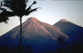
Fuego
Guatemala
14.473°N, 90.88°W; summit elev. 3763 m
All times are local (unless otherwise noted)
The Instituto Nacional de Sismología, Vulcanología, Meteorología e Hidrología (INSIVUMEH) reported that elevated eruptive activity at Fuego was characterized by explosions and ash plumes, incandescent material ejected above the summit, incandescent avalanches, and pyroclastic flows. The stronger activity began at around 0255 on 9 March with explosions detected in seismic and acoustic data and increasing thermal radiance at the summit detected in satellite data. Explosions ejected incandescent material onto the upper flanks on all directions and caused avalanches of incandescent material. Explosions and gas ejections were heard in areas several kilometers away. According to the Washington VAAC significant ash plumes rose about 1.1 km above the summit at 0350, but by 0930 the plumes were more sporadic and diffuse; the plumes drifted W and NW. INSIVUMEH noted that activity intensified in the early evening and became continuous. The VAAC reported that at 1620 ash plumes rose around 500 m above the summit and drifted W. At around 1800 air quality monitoring stations in Guatemala City recorded decreased quality conditions due to ash in the air, according to CONRED. The VAAC reported that at 2200 dense ash emissions rose 500 m and drifted 150 km SW while a second plume rose 1.1 km above the summit and drifted NW.
Activity notably intensified again at 2100 on 9 March. Lava fountains rose 300 m above the summit, avalanches of incandescent blocks descended the flanks, and shockwaves from explosions rattled nearby houses and structures. Ash plumes rose 3.2 km above the summit and fanned out as far as 50 km SW, W, and NW. Continuous ashfall was reported in areas W and S. Just before 2330 pyroclastic flows descended the Seca (W) and Ceniza (SSW) drainages and about 25 minutes later pyroclastic flows descended the Las Lajas (SE) and El Jute (ESE) drainages. CONRED staff assisted 267 people from El Porvenir and 15 from Las Lajitas to an evacuation shelter in the Municipal Hall of San Juan Alotenango, Sacatepéquez. A section of the RN-14, the national route connecting Escuintla and Sacatepéquez, was temporarily closed as a preventative measure.
Overnight during 9-10 March lava fountains rose 500 m high. Dense ash-and-gas plumes rose 6 km above the summit and drifted 100-120 km NW and E. Low-altitude plumes with ash remobilized from earlier pyroclastic flows drifted SW. On 10 March the Ministry of Education suspended classes in the municipalities of Alotenango, Sacatepéquez; Escuintla and Siquinalá in the department of Escuintla; and in San Pedro Yepocapa, Chimaltenango. Activity began to decrease and by 1130 on 10 March explosions were no longer continuous. Ash-and-gas plumes rose 1.1 km above the summit and drifted 100 km NW and SW. Minor ashfall continued to impact areas to the W and SW; ash remained suspended in the air and ashfall on crops was up to 1 mm thick. By 1230 the air quality monitoring station in Guatemala City recorded improved quality conditions due to less ash in the air. Activity continued to decline. INSIVUMEH issued a report at 1800 noting that activity had returned to “baseline” levels; seismicity was at “normal” levels and satellite data indicated that large amounts of ash were no longer suspended in the air. Thermal anomalies were also no longer detected in satellite data. Overnight during 10-11 March a few incandescent blocks in the crater were visible along with minor avalanches of incandescent material. Diffuse gas emissions rose form the crater. During 11-12 March gas emissions rose about 100 m above the summit and no incandescent explosions were observed.
Geological Summary. Volcán Fuego, one of Central America's most active volcanoes, is also one of three large stratovolcanoes overlooking Guatemala's former capital, Antigua. The scarp of an older edifice, Meseta, lies between Fuego and Acatenango to the north. Construction of Meseta dates back to about 230,000 years and continued until the late Pleistocene or early Holocene. Collapse of Meseta may have produced the massive Escuintla debris-avalanche deposit, which extends about 50 km onto the Pacific coastal plain. Growth of the modern Fuego volcano followed, continuing the southward migration of volcanism that began at the mostly andesitic Acatenango. Eruptions at Fuego have become more mafic with time, and most historical activity has produced basaltic rocks. Frequent vigorous historical eruptions have been recorded since the onset of the Spanish era in 1524, and have produced major ashfalls, along with occasional pyroclastic flows and lava flows.
Sources: Instituto Nacional de Sismologia, Vulcanologia, Meteorologia, e Hidrologia (INSIVUMEH), Coordinadora Nacional para la Reducción de Desastres (CONRED)