Report on Awu (Indonesia) — 26 March-1 April 2025
Smithsonian Institution / US Geological Survey
Weekly Volcanic Activity Report, 26 March-1 April 2025
Managing Editor: Sally Sennert.
Please cite this report as:
Global Volcanism Program, 2025. Report on Awu (Indonesia) (Sennert, S, ed.). Weekly Volcanic Activity Report, 26 March-1 April 2025. Smithsonian Institution and US Geological Survey.
Awu
Indonesia
3.689°N, 125.447°E; summit elev. 1318 m
All times are local (unless otherwise noted)
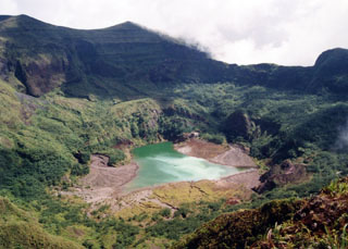
The Pusat Vulkanologi dan Mitigasi Bencana Geologi (PVMBG) reported that seismicity at Awu had increased. During March fluctuating levels of emissions rose as high as 200 m above the lava dome on the main crater floor and did not indicate an increase in activity. Tiltmeter data continued to show an inflationary trend. On 28 March there was an increase in the number of low-frequency earthquakes, indicating fluid movement at depth, and was accompanied by a relatively high number of shallow volcanic earthquakes. The Alert Level remained at 2 (on a scale of 1-4) and the public was warned to stay 3 km away from the crater’s center.
Geological Summary. The massive Gunung Awu stratovolcano occupies the northern end of Great Sangihe Island, the largest of the Sangihe arc. Deep valleys that form passageways for lahars dissect the flanks of the volcano, which was constructed within a 4.5-km-wide caldera. Powerful explosive eruptions in 1711, 1812, 1856, 1892, and 1966 produced devastating pyroclastic flows and lahars that caused more than 8000 cumulative fatalities. Awu contained a summit crater lake that was 1 km wide and 172 m deep in 1922, but was largely ejected during the 1966 eruption.
Source: Pusat Vulkanologi dan Mitigasi Bencana Geologi (PVMBG, also known as CVGHM)