Report on Kirishimayama (Japan) — 23 July-29 July 2025
Smithsonian Institution / US Geological Survey
Weekly Volcanic Activity Report, 23 July-29 July 2025
Managing Editor: Sally Sennert.
Please cite this report as:
Global Volcanism Program, 2025. Report on Kirishimayama (Japan) (Sennert, S, ed.). Weekly Volcanic Activity Report, 23 July-29 July 2025. Smithsonian Institution and US Geological Survey.
Kirishimayama
Japan
31.934°N, 130.862°E; summit elev. 1700 m
All times are local (unless otherwise noted)
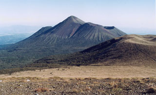
The Japan Meteorological Agency (JMA) reported that eruptive activity continued at Shinmoedake (Shinmoe peak, a stratovolcano of the Kirishimayama volcano group) during 22-29 July. The number of volcanic earthquakes located beneath Shinmoedake, first detected in late October 2024, continued to fluctuate; volcanic tremor was also occasionally detected. Diffuse grayish-white plumes rose 100-200 m above the crater rim and drifted W during 22-24 July. Eruptive events were detected on 27 July but weather conditions obscured views. The Alert Level remained at 3 (on a 5-level scale) and the public was warned to exercise caution within 3 km from Shinmoedake Crater.
Geological Summary. Kirishimayama is a large group of more than 20 Quaternary volcanoes located north of Kagoshima Bay. The late-Pleistocene to Holocene dominantly andesitic group consists of stratovolcanoes, pyroclastic cones, maars, and underlying shield volcanoes located over an area of 20 x 30 km. The larger stratovolcanoes are scattered throughout the field, with the centrally located Karakunidake being the highest. Onamiike and Miike, the two largest maars, are located SW of Karakunidake and at its far eastern end, respectively. Holocene eruptions have been concentrated along an E-W line of vents from Miike to Ohachi, and at Shinmoedake to the NE. Frequent small-to-moderate explosive eruptions have been recorded since the 8th century.