Report on Merapi (Indonesia) — 30 July-5 August 2025
Smithsonian Institution / US Geological Survey
Weekly Volcanic Activity Report, 30 July-5 August 2025
Managing Editor: Sally Sennert.
Written by USGS Volcano Disaster Assistance Program Staff.
Please cite this report as:
Global Volcanism Program, 2025. Report on Merapi (Indonesia) (USGS Volcano Disaster Assistance Program Staff and Sennert, S, eds.). Weekly Volcanic Activity Report, 30 July-5 August 2025. Smithsonian Institution and US Geological Survey.
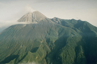
Merapi
Indonesia
7.54°S, 110.446°E; summit elev. 2910 m
All times are local (unless otherwise noted)
The Balai Penyelidikan dan Pengembangan Teknologi Kebencanaan Geologi (BPPTKG) reported that the eruption at Merapi (on Java) continued during 25-31 July. During that 19 avalanches were observed descending into the upper reaches of the Krasak River and reaching as far as 2 km from the summit. There were six avalanches in the upper reaches of the Bebeng River that traveled as far as 1.9 km. Fifty avalanches descended into the upper Sat/Putih River, extending a maximum of 2 km. Based on analysis of aerial photos from 17 July, the volume of the SW lava dome and the central dome were 4,011,000 cubic meters and 2,368,900 cubic meters, respectively. Small morphological changes to the SW lava dome resulted from continuing effusion and minor collapses. The Alert Level remained at 3 (on a scale of 1-4), and the public was warned to stay 3-7 km away from the summit, based on location.
Geological Summary. Merapi, one of Indonesia's most active volcanoes, lies in one of the world's most densely populated areas and dominates the landscape immediately north of the major city of Yogyakarta. It is the youngest and southernmost of a volcanic chain extending NNW to Ungaran volcano. Growth of Old Merapi during the Pleistocene ended with major edifice collapse perhaps about 2,000 years ago, leaving a large arcuate scarp cutting the eroded older Batulawang volcano. Subsequent growth of the steep-sided Young Merapi edifice, its upper part unvegetated due to frequent activity, began SW of the earlier collapse scarp. Pyroclastic flows and lahars accompanying growth and collapse of the steep-sided active summit lava dome have devastated cultivated lands on the western-to-southern flanks and caused many fatalities.
Source: Balai Penyelidikan dan Pengembangan Teknologi Kebencanaan Geologi (BPPTKG)