Report on Kusatsu-Shiranesan (Japan) — 30 July-5 August 2025
Smithsonian Institution / US Geological Survey
Weekly Volcanic Activity Report, 30 July-5 August 2025
Managing Editor: Sally Sennert.
Written by USGS Volcano Disaster Assistance Program Staff.
Please cite this report as:
Global Volcanism Program, 2025. Report on Kusatsu-Shiranesan (Japan) (USGS Volcano Disaster Assistance Program Staff and Sennert, S, eds.). Weekly Volcanic Activity Report, 30 July-5 August 2025. Smithsonian Institution and US Geological Survey.
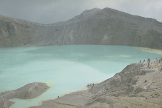
Kusatsu-Shiranesan
Japan
36.618°N, 138.528°E; summit elev. 2165 m
All times are local (unless otherwise noted)
The Japan Meteorological Agency (JMA) reported increased unrest near Kusatsu-Shiranesan’s Yugama crater starting around 1500 on 3 August, characterized by an increase in volcanic earthquakes with epicenters near the Yugama crater. Additionally, ground deformation data since June 2024 indicated minor uplift of the NW Yugama crater area. Low-amplitude, short-duration seismic tremor recorded on 2 August was the first since 12 November 2020. Volcanic earthquakes continued to be recorded, prompting the JMA to raise the alert level at 0550 on 4 August to Level 2 (on a 5-level scale). The public was advised to maintain a minimum distance of 1 km from Yugama Crater.
Geological Summary. The Kusatsu-Shiranesan complex, located immediately north of Asama volcano, consists of a series of overlapping pyroclastic cones and three crater lakes. The andesitic-to-dacitic volcano was formed in three eruptive stages beginning in the early to mid-Pleistocene. The Pleistocene Oshi pyroclastic flow produced extensive welded tuffs and non-welded pumice that covers much of the E, S, and SW flanks. The latest eruptive stage began about 14,000 years ago. Historical eruptions have consisted of phreatic explosions from the acidic crater lakes or their margins. Fumaroles and hot springs that dot the flanks have strongly acidified many rivers draining from the volcano. The crater was the site of active sulfur mining for many years during the 19th and 20th centuries.