Report on Kilauea (United States) — 30 July-5 August 2025
Smithsonian Institution / US Geological Survey
Weekly Volcanic Activity Report, 30 July-5 August 2025
Managing Editor: Sally Sennert.
Written by USGS Volcano Disaster Assistance Program Staff.
Please cite this report as:
Global Volcanism Program, 2025. Report on Kilauea (United States) (USGS Volcano Disaster Assistance Program Staff and Sennert, S, eds.). Weekly Volcanic Activity Report, 30 July-5 August 2025. Smithsonian Institution and US Geological Survey.
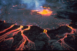
Kilauea
United States
19.421°N, 155.287°W; summit elev. 1222 m
All times are local (unless otherwise noted)
The Hawaiian Volcano Observatory (HVO) reported that episodic eruptive activity within Halema‘uma‘u crater and the SW area of Kaluapele (Kilauea summit caldera), continued at variable levels during 30 July-5 August. Incandescence was observed at the northern vent on the morning of 31 July and continued to be visible in webcam images overnight. Other areas within the crater showed very low levels of incandescence, with only faint, intermittent glow from two locations higher on the eruptive cone in overnight webcam images.
Summit tilt varied more than usual during the reporting period, with deflationary activity recorded during the night of 1 August through the morning of 3 August before briefly switching back to inflation. Then, around 0400 on 4 August, ground deformation data (tiltmeter) showed that minor summit deflation had resumed. During 0514-0518 on 4 August, a gas-pistoning event occurred at the north vent, with lava briefly appearing before draining back without any overflow or significant spattering activity. A second gas-pistoning event followed at 0551, during which there was minor spattering and lava overflowed the vent, which drained back by 0559. Ground deformation stalled around 0600, with no net inflation recorded since the night of 1 August. Strong incandescence was observed from the north vent early in the morning on 5 August, with occasional spattering observed in webcam images. A helicopter overflight later in the morning confirmed that lava was 5-10 m from the top of the vent. The degassed lava was observed feeding a low-volume flow into a lava tube within older lava flows on the crater floor.
No new surface lava flows or incandescent breakouts were observed on the Halema‘uma‘u crater floor in connection with this activity. The Volcano Alert Level remained at Watch (the third level on a four-level scale) and the Aviation Color Code remained at Orange (the third color on a four-color scale).
Geological Summary. Kilauea overlaps the E flank of the massive Mauna Loa shield volcano in the island of Hawaii. Eruptions are prominent in Polynesian legends; written documentation since 1820 records frequent summit and flank lava flow eruptions interspersed with periods of long-term lava lake activity at Halemaumau crater in the summit caldera until 1924. The 3 x 5 km caldera was formed in several stages about 1,500 years ago and during the 18th century; eruptions have also originated from the lengthy East and Southwest rift zones, which extend to the ocean in both directions. About 90% of the surface of the basaltic shield volcano is formed of lava flows less than about 1,100 years old; 70% of the surface is younger than 600 years. The long-term eruption from the East rift zone between 1983 and 2018 produced lava flows covering more than 100 km2, destroyed hundreds of houses, and added new coastline.
Source: US Geological Survey Hawaiian Volcano Observatory (HVO)