Report on Mayon (Philippines) — 3 September-9 September 2025
Smithsonian Institution / US Geological Survey
Weekly Volcanic Activity Report, 3 September-9 September 2025
Managing Editor: Sally Sennert.
Please cite this report as:
Global Volcanism Program, 2025. Report on Mayon (Philippines) (Sennert, S, ed.). Weekly Volcanic Activity Report, 3 September-9 September 2025. Smithsonian Institution and US Geological Survey.
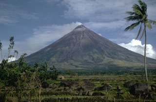
Mayon
Philippines
13.257°N, 123.685°E; summit elev. 2462 m
All times are local (unless otherwise noted)
The Philippine Institute of Volcanology and Seismology (PHIVOLCS) reported increased seismic activity at Mayon. During 0000-1730 on 6 September the seismic network recorded 26 volcanic earthquakes with local magnitudes of 0.4-2.7 which were located 5-10 km beneath the NE flank. Variable inflation had been detected at the NE sector since October 2024 and at the S and SW sectors since March 2025, based on continuous GPS, electronic tilt, and Electronic Distance Measurement (EDM) ground deformation data. Sulfur dioxide emissions remained near background levels, averaging 430 tonnes/day (t/d) in 2025, with the latest measurement of 609 t/d on 3 September. The Alert Level remained at 1 (on a 0-5 scale); the public was warned to stay out of the 6-km-radius Permanent Danger Zone (PDZ) and pilots were advised to avoid flying close to the summit.
Geological Summary. Symmetrical Mayon, which rises above the Albay Gulf NW of Legazpi City, is the most active volcano of the Philippines. The steep upper slopes are capped by a small summit crater. Recorded eruptions since 1616 CE range from Strombolian to basaltic Plinian, with cyclical activity beginning with basaltic eruptions, followed by longer periods of andesitic lava flows. Eruptions occur predominately from the central conduit and have also produced lava flows that travel far down the flanks. Pyroclastic density currents and mudflows have commonly swept down many of the approximately 40 ravines that radiate from the summit and have often damaged populated lowland areas. A violent eruption in 1814 killed more than 1,200 people and devastated several towns.
Source: Philippine Institute of Volcanology and Seismology (PHIVOLCS)