Report on Semeru (Indonesia) — 12 November-18 November 2025
Smithsonian Institution / US Geological Survey
Weekly Volcanic Activity Report, 12 November-18 November 2025
Managing Editor: Sally Sennert.
Please cite this report as:
Global Volcanism Program, 2025. Report on Semeru (Indonesia) (Sennert, S, ed.). Weekly Volcanic Activity Report, 12 November-18 November 2025. Smithsonian Institution and US Geological Survey.
Semeru
Indonesia
8.108°S, 112.922°E; summit elev. 3657 m
All times are local (unless otherwise noted)
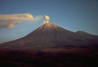
The Pusat Vulkanologi dan Mitigasi Bencana Geologi (PVMBG) reported that activity continued at Semeru during 13-18 November with a larger eruption on 19 November. White-and-gray or gray ash plumes rose 400-800 m above the summit and drifted N, NE, and E during 13-14 and 16-17 November. Eruptive events were sometimes recorded during 14-17 November, but weather conditions prevented visual confirmation.
At 1413 on 19 November activity intensified and a series of pyroclastic density currents (PDCs) traveled down the flanks. Although foggy conditions obscured views, incandescent avalanches of material were visible descending the Besuk Kobokan drainage on the S flank. PDCs continued descending the flanks through 1558. At 1600 the Alert level was raised to 3 (the second highest level on a scale of 1-4) and the public was warned to stay at least 5 km away from the summit in all directions, 17 km from the summit to the SE, and 500 m from the banks of the Kobokan drainage as far as 17 km from the summit. Seismicity activity indicated that the eruption continued at a high level with increasing numbers of signals indicating avalanches. At 1700 the Alert level was raised to 4 (the highest level) and the exclusion zone was expanded 8 km from the summit in all directions, 20 km from the summit to the SE, and 500 m from the banks of the Kobokan drainage. According to the Badan Nacional Penanggulangan Bencana (BNPB) PDCs traveled as far as 13 km down the SE and S flanks, though a news article noted that they may have traveled as far as 14 km. The Darwin VAAC reported that ash plumes rose 16.5-18 km (54,000-59,000 ft) a.s.l. and drifted SW during 1740-2040 on 19 November based on satellite data, webcam images, and ground reports. BNPB stated that the communities of Supit Urang and Oro-Oro Ombo in Pronojiwo sub-district and Penanggal in Candipuro sub-district were affected, causing the evacuation of about 300 residents to evacuation centers. Some residents reported a sulfur odor. A news article noted that two motorcyclists crashed due to hot ash on the Gladak Perak bridge, resulting in severe burns on their bodies.
Geological Summary. Semeru, the highest volcano on Java, and one of its most active, lies at the southern end of a volcanic massif extending north to the Tengger caldera. The steep-sided volcano, also referred to as Mahameru (Great Mountain), rises above coastal plains to the south. Gunung Semeru was constructed south of the overlapping Ajek-ajek and Jambangan calderas. A line of lake-filled maars was constructed along a N-S trend cutting through the summit, and cinder cones and lava domes occupy the eastern and NE flanks. Summit topography is complicated by the shifting of craters from NW to SE. Frequent 19th and 20th century eruptions were dominated by small-to-moderate explosions from the summit crater, with occasional lava flows and larger explosive eruptions accompanied by pyroclastic flows that have reached the lower flanks of the volcano.
Sources: Pusat Vulkanologi dan Mitigasi Bencana Geologi (PVMBG, also known as CVGHM), Badan Nacional Penanggulangan Bencana (BNPB), Darwin Volcanic Ash Advisory Centre (VAAC), Antara News, Antara News