
On 4 November, bubbling, a strong sulfur smell, and micro-telluric tremor were observed in the sea near Panarea Island in the Aeolian Archipelago. The submarine hydrothermal activity killed hundreds of fish. According to Stromboli On-Line, the temperature of the water in the area was not very high (~25°C). They stated that an intensification of degassing and consequent bubbling occurred in the area surrounding the small islet of Lisca Bianca, about 2 km E of Panarea.
Sources: Associated Press, Stromboli On-Line
Intense bubbling ends, but degassing continues through March 2003
On 3 November 2002, intense degassing caused bubbling activity near the small islet of Lisca Bianca, very close to the island of Panarea (BGVN 27:10). On 13-14 November 2002, observers Orlando Vaselli (University of Florence), Bruno Capaccioni (University of Urbino), and Piermaria Luigi Rossi (University of Bologna) noted 10 points of boiling water when they visited the area to sample gas emissions.
Geochemical monitoring and research is being regularly performed by the Fluid Geochemistry group from the Osservatorio Vesuviano (Istituto Nazionale di Geofisica e Vulcanologia), led by Giovanni Chiodini. Submarine gas emissions were sampled during 29-30 November and 10-17 December 2002, as well as 23-24 January and 9-11 February 2003. Samples obtained during March, April, and May have not yet been analyzed. Chiodini noted that although the intensity of emissions decreased after 5 November 2002 (BGVN 27:10), the gas flux remained much higher than before the November event. That observation, along with chemical variations in gas samples, indicate that the process is ongoing. Research results posted on the Osservatorio Vesuviano website provide additional details, analytical findings, and hypotheses about these phenomena.
Information Contacts: Giovanni Chiodini, Unità Funzionale di Geochimica dei Fluidi, Osservatorio Vesuviano, Istituto Nazionale di Geofisica e Vulcanologia, Via Diocleziano, 328-80124 Napoli, Italy (URL: http://www.ov.ingv.it/); Orlando Vaselli, Dipartimento di Scienze della Terra, Universita' degli Studi di Firenze, Via La Pira 4, 50121 Firenze, Italy; Stromboli Online (URL: http://www.stromboli.net/).
2002: November
On 4 November, bubbling, a strong sulfur smell, and micro-telluric tremor were observed in the sea near Panarea Island in the Aeolian Archipelago. The submarine hydrothermal activity killed hundreds of fish. According to Stromboli On-Line, the temperature of the water in the area was not very high (~25°C). They stated that an intensification of degassing and consequent bubbling occurred in the area surrounding the small islet of Lisca Bianca, about 2 km E of Panarea.
Sources: Associated Press; Stromboli On-Line
Reports are organized chronologically and indexed below by Month/Year (Publication Volume:Number), and include a one-line summary. Click on the index link or scroll down to read the reports.
Increased submarine fumarolic activity near Panarea Island
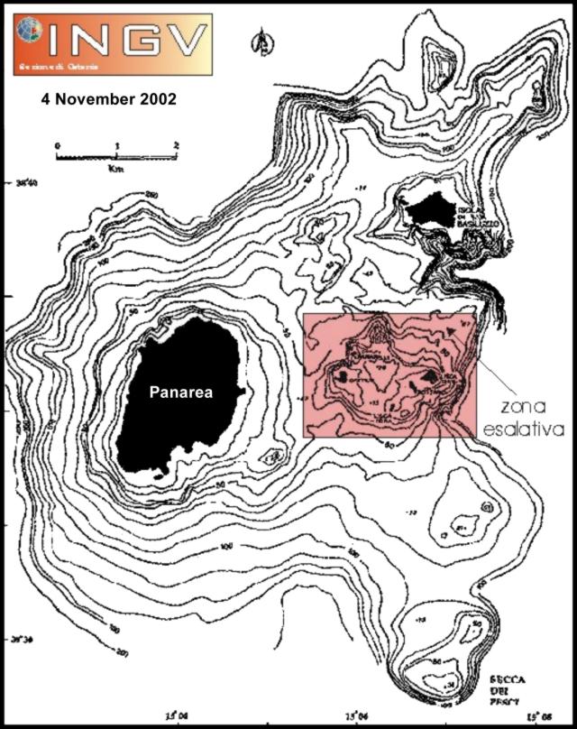
On 3 November 2002, fishermen reported strong exhalative phenomena in the Lisca Bianca-Bottaro-Lisca Nera area, E of Panarea Island (figure 1). They described boiling seawater, dead fish, and an intense sulfur smell. On 4 November, scientists of the Istituto Nazionale di Geofisica e Vulcanologia (INGV) carried out aerial and sea surveys between Panarea and the Lisca Bianca-Dattilo-Bottaro islets from a Civil Protection helicopter and a Coast Guard boat.
 |
Figure 1. Bathymetric map of the Panarea Island area, showing the area of degassing in November 2002. Modified from Gabbianelli et. al. (1990); courtesy of INGV. |
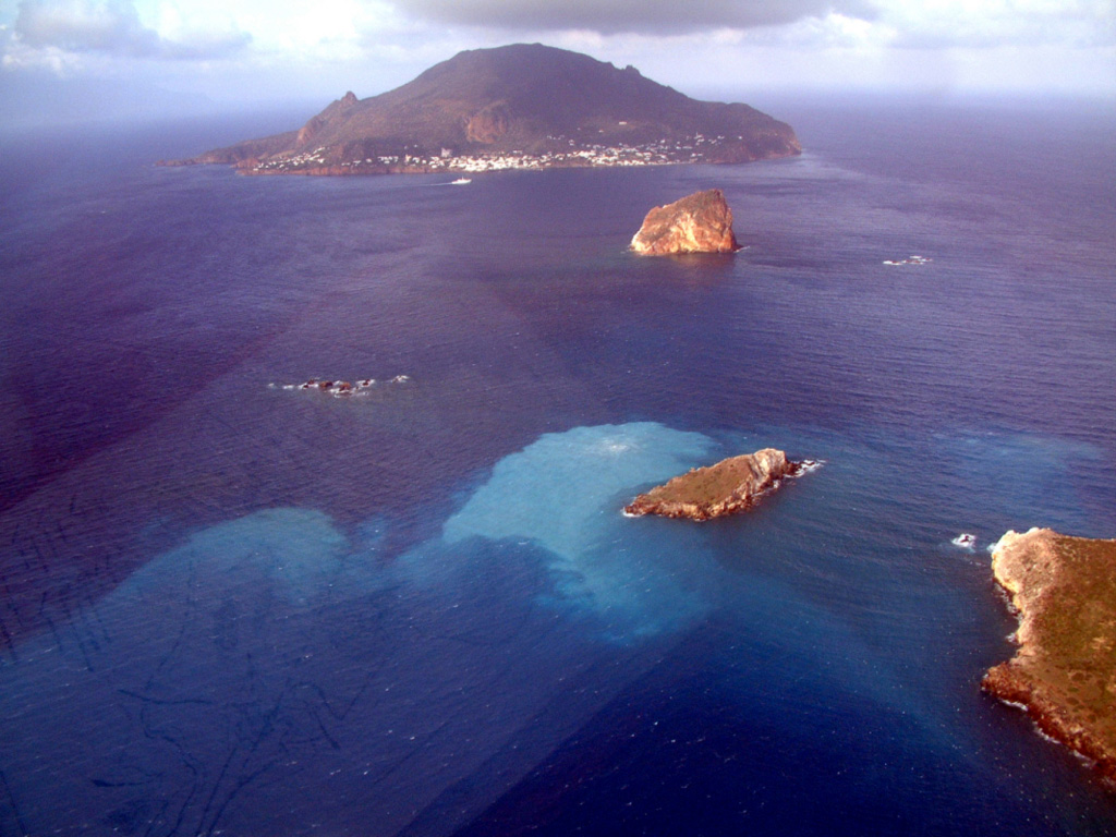
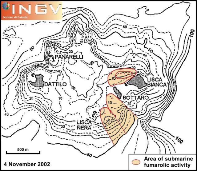
In three distinct areas between Lisca Bianca and Lisca Nera (figure 2), discolored water was visible, accompanied by intense gas bubbling. The first area, located W of Lisca Bianca, had three distinct degassing points in which bubbles with diameters of some meters reached the sea surface. A second area stretched SSE from W of Bottaro; on the sea surface there was only one point where vigorous outbursts of meter-sized bubbles were noted (figure 3). The third and smallest area was just SW of the second one. Water depths in all three areas are shallower than 30 m.
 |
Figure 2. Bathymetric map and location of degassing points on 4 November 2002. Modified from Gabbianelli et. al. (1996); courtesy of INGV. |
 |
Figure 3. Aerial photo of the Lisca Bianca-Bottaro-Lisca Nera-Panarea Island area with evident water discoloration phenomena on 4 November 2002. Courtesy of INGV. |
During the preliminary survey, INGV scientists recorded thermal images of the sea surface. Direct pH and temperature measurements were carried out at different depths, and seawater samples were collected. Neither temperature measurements nor thermal images identified appreciable thermal anomalies, because water temperatures (22-23°C) near the degassing points were similar to those close to the island's pier. Conversely, pH values were about 5.6-5.7, significantly lower than typical seawater values.
A field survey was also carried out in the Calcara Beach area, where fumarolic activity has been known since the Roman Age. No anomalies were detected in either the fumarolic flux or in the measured temperature (100°C). Finally, field and aerial surveys were performed in order to exclude the occurrence of ground fissuring or other related anomalous phenomena on Panarea Island.
On 5 November the aerial survey highlighted a remarkable decrease in the intensity of exhalation activity and a sharp reduction of the area affected by water discoloration. In particular, gas bubbling was restricted to the area W of Bottaro. Repeated thermal investigations did not find any significant anomaly. Vigorous bubbling and water discoloration further decreased in the following days.
Seismicity. In the early morning on 3 November the INGV seismic station PAN recorded a swarm of microseisms close to Panarea. PAN, in the E part of the island, is equipped with a 1-Hz vertical seismometer. Although isolated micro-events were recorded beginning at 0253 GMT, the most intense phase of the swarm, in terms of number of events, occurred between 0337 and 0500 GMT. During the swarm, geophysicists noted some hundreds of micro-events with average durations of 8 seconds and magnitudes generally less than 1. After the climax, isolated events continued. Overall, there were a few events with magnitudes between 1 and 1.5; it was impossible to locate their hypocenters because they were not detected at stations more distant from the island. According to S-P arrival time differences, the source could lay within a radius of 2-3 km from the island. The spectrum of the events analyzed shows a broad frequency content, with dominant peaks from 5 to 16 Hz.
Background. Panarea, the smallest island of the Aeolian volcanic arc in the Southern Tyrrhenian Sea, is located ~30 km SW of Stromboli. Panarea is a cone-shaped edifice rising from 1,700 m below sea level to 421 m at Punta del Corvo peak. The subaerial portion of the island was built by prevailing effusive activity and emplacement of domes from 149 to 124 Ka (Calanchi et al., 1999). A second stage, during which pyroclastic activity prevailed, occurred between 59 and 13 Ka (Losito, 1989). As of November 2002 the only volcanic activity consists of a broad fumarolic field in a submarine crater, whose rim is inferred by the semicircular distribution of the islets of Dattilo, Lisca Bianca, Bottaro, and Lisca Nera (Gabbianelli et al., 1990, Italiano and Nuccio, 1991). Panarea and the Aeolian Islands are monitored by the Istiuto Nazioanle di Geofisica e Vulcanologias, Sezz. Catania and Palermo.
References. Calanchi, N., Tranne, C.A., Lucchini, F., Rossi, P.L., and Villa, I.M., 1999, Explanatory notes to the geological map (1:10000) of Panarea and Basiluzzo islands (Aeolian arc. Italy): Acta Vulcanologica, v. 11, no. 2, p. 223-243.
Gabbianelli, G., Gillot, P.Y., Lanzafame, G., Romagnoli, C., and Rossi, P.L., 1990, Tectonic and volcanic evolution of Panarea (Aeolian Islands, Italy): Marine Geology, v. 92, p. 313-326.
Gabbianelli, G., Cortecci, G., Capra, A., Giacomelli, L., Pompilio, M., and Rossi, P.L., 1996, Lineamenti geo-vulcanologici ed ambientali del'area craterica sottomarina di Dattilo-Lisca Bianca (Isola di Panarea, Arcipelago Eoliano) in Caratterizzazione ambientale marina del sistema Eolie e dei bacini limitrofi di Cefalù e Gioia (EOCUMM 95) (edited by Faranda, F.M., and Povero, P.): Data Report, p. 455-462.
Italiano, F., and Nuccio, P.M., 1991, Geochemical investigation of submarine volcanic exhalations to the east of Panarea, Aeolian Islands, Italy: Journal of Volcanology and Geothermal Research, v. 46, p. 125-141.
Losito, R., 1989, Stratigrafia, caratteri deposizionali e aree sorgenti dei Tufi Bruni delle Isole Eolie: Unpublished Ph.D. thesis, Bari University, 92 p.
Information Contacts: Susanna Falsaperla, Luigi Lodato, and Massimo Pompilio, Istituto Nazionale di Geofisica e Vulcanologia - Sezione di Catania (INGV), Piazza Roma, 2, 95123 Catania, Italy (URL: http://www.ct.ingv.it/en/).
Intense bubbling ends, but degassing continues through March 2003
On 3 November 2002, intense degassing caused bubbling activity near the small islet of Lisca Bianca, very close to the island of Panarea (BGVN 27:10). On 13-14 November 2002, observers Orlando Vaselli (University of Florence), Bruno Capaccioni (University of Urbino), and Piermaria Luigi Rossi (University of Bologna) noted 10 points of boiling water when they visited the area to sample gas emissions.
Geochemical monitoring and research is being regularly performed by the Fluid Geochemistry group from the Osservatorio Vesuviano (Istituto Nazionale di Geofisica e Vulcanologia), led by Giovanni Chiodini. Submarine gas emissions were sampled during 29-30 November and 10-17 December 2002, as well as 23-24 January and 9-11 February 2003. Samples obtained during March, April, and May have not yet been analyzed. Chiodini noted that although the intensity of emissions decreased after 5 November 2002 (BGVN 27:10), the gas flux remained much higher than before the November event. That observation, along with chemical variations in gas samples, indicate that the process is ongoing. Research results posted on the Osservatorio Vesuviano website provide additional details, analytical findings, and hypotheses about these phenomena.
Information Contacts: Giovanni Chiodini, Unità Funzionale di Geochimica dei Fluidi, Osservatorio Vesuviano, Istituto Nazionale di Geofisica e Vulcanologia, Via Diocleziano, 328-80124 Napoli, Italy (URL: http://www.ov.ingv.it/); Orlando Vaselli, Dipartimento di Scienze della Terra, Universita' degli Studi di Firenze, Via La Pira 4, 50121 Firenze, Italy; Stromboli Online (URL: http://www.stromboli.net/).
|
|
||||||||||||||||||||||||||||
The Global Volcanism Program is not aware of any Holocene eruptions from Panarea. If this volcano has had large eruptions (VEI >= 4) prior to 12,000 years ago, information might be found on the Panarea page in the LaMEVE (Large Magnitude Explosive Volcanic Eruptions) database, a part of the Volcano Global Risk Identification and Analysis Project (VOGRIPA).
This compilation of synonyms and subsidiary features may not be comprehensive. Features are organized into four major categories: Cones, Craters, Domes, and Thermal Features. Synonyms of features appear indented below the primary name. In some cases additional feature type, elevation, or location details are provided.
Craters |
||||
| Feature Name | Feature Type | Elevation | Latitude | Longitude |
| Central Reefs | Crater | 103 m | 38° 38' 23.00" N | 15° 6' 20.00" E |
Domes |
||||
| Feature Name | Feature Type | Elevation | Latitude | Longitude |
| Basiluzzo | Dome | 145 m | 38° 39' 49.00" N | 15° 6' 42.00" E |
| Cala Bianca | Dome | |||
| Castello | Dome | 213 m | 38° 37' 55.00" N | 15° 3' 52.00" E |
| Secca dei Pesci | Dome | -42 m | 38° 35' 32.00" N | 15° 6' 40.00" E |
Thermal |
||||
| Feature Name | Feature Type | Elevation | Latitude | Longitude |
| Calcara, La | Thermal | |||
| Lisca Bianca-Bottaro | Thermal | |||
| Punta Levante | Thermal | |||
There are no samples for Panarea in the Smithsonian's NMNH Department of Mineral Sciences Rock and Ore collection.
| Copernicus Browser | The Copernicus Browser replaced the Sentinel Hub Playground browser in 2023, to provide access to Earth observation archives from the Copernicus Data Space Ecosystem, the main distribution platform for data from the EU Copernicus missions. |
| MIROVA | Middle InfraRed Observation of Volcanic Activity (MIROVA) is a near real time volcanic hot-spot detection system based on the analysis of MODIS (Moderate Resolution Imaging Spectroradiometer) data. In particular, MIROVA uses the Middle InfraRed Radiation (MIR), measured over target volcanoes, in order to detect, locate and measure the heat radiation sourced from volcanic activity. |
| MODVOLC Thermal Alerts | Using infrared satellite Moderate Resolution Imaging Spectroradiometer (MODIS) data, scientists at the Hawai'i Institute of Geophysics and Planetology, University of Hawai'i, developed an automated system called MODVOLC to map thermal hot-spots in near real time. For each MODIS image, the algorithm automatically scans each 1 km pixel within it to check for high-temperature hot-spots. When one is found the date, time, location, and intensity are recorded. MODIS looks at every square km of the Earth every 48 hours, once during the day and once during the night, and the presence of two MODIS sensors in space allows at least four hot-spot observations every two days. Each day updated global maps are compiled to display the locations of all hot spots detected in the previous 24 hours. There is a drop-down list with volcano names which allow users to 'zoom-in' and examine the distribution of hot-spots at a variety of spatial scales. |
|
WOVOdat
Single Volcano View Temporal Evolution of Unrest Side by Side Volcanoes |
WOVOdat is a database of volcanic unrest; instrumentally and visually recorded changes in seismicity, ground deformation, gas emission, and other parameters from their normal baselines. It is sponsored by the World Organization of Volcano Observatories (WOVO) and presently hosted at the Earth Observatory of Singapore.
GVMID Data on Volcano Monitoring Infrastructure The Global Volcano Monitoring Infrastructure Database GVMID, is aimed at documenting and improving capabilities of volcano monitoring from the ground and space. GVMID should provide a snapshot and baseline view of the techniques and instrumentation that are in place at various volcanoes, which can be use by volcano observatories as reference to setup new monitoring system or improving networks at a specific volcano. These data will allow identification of what monitoring gaps exist, which can be then targeted by remote sensing infrastructure and future instrument deployments. |
| Volcanic Hazard Maps | The IAVCEI Commission on Volcanic Hazards and Risk has a Volcanic Hazard Maps database designed to serve as a resource for hazard mappers (or other interested parties) to explore how common issues in hazard map development have been addressed at different volcanoes, in different countries, for different hazards, and for different intended audiences. In addition to the comprehensive, searchable Volcanic Hazard Maps Database, this website contains information about diversity of volcanic hazard maps, illustrated using examples from the database. This site is for educational purposes related to volcanic hazard maps. Hazard maps found on this website should not be used for emergency purposes. For the most recent, official hazard map for a particular volcano, please seek out the proper institutional authorities on the matter. |
| IRIS seismic stations/networks | Incorporated Research Institutions for Seismology (IRIS) Data Services map showing the location of seismic stations from all available networks (permanent or temporary) within a radius of 0.18° (about 20 km at mid-latitudes) from the given location of Panarea. Users can customize a variety of filters and options in the left panel. Note that if there are no stations are known the map will default to show the entire world with a "No data matched request" error notice. |
| UNAVCO GPS/GNSS stations | Geodetic Data Services map from UNAVCO showing the location of GPS/GNSS stations from all available networks (permanent or temporary) within a radius of 20 km from the given location of Panarea. Users can customize the data search based on station or network names, location, and time window. Requires Adobe Flash Player. |
| DECADE Data | The DECADE portal, still in the developmental stage, serves as an example of the proposed interoperability between The Smithsonian Institution's Global Volcanism Program, the Mapping Gas Emissions (MaGa) Database, and the EarthChem Geochemical Portal. The Deep Earth Carbon Degassing (DECADE) initiative seeks to use new and established technologies to determine accurate global fluxes of volcanic CO2 to the atmosphere, but installing CO2 monitoring networks on 20 of the world's 150 most actively degassing volcanoes. The group uses related laboratory-based studies (direct gas sampling and analysis, melt inclusions) to provide new data for direct degassing of deep earth carbon to the atmosphere. |
| Large Eruptions of Panarea | Information about large Quaternary eruptions (VEI >= 4) is cataloged in the Large Magnitude Explosive Volcanic Eruptions (LaMEVE) database of the Volcano Global Risk Identification and Analysis Project (VOGRIPA). |
| EarthChem | EarthChem develops and maintains databases, software, and services that support the preservation, discovery, access and analysis of geochemical data, and facilitate their integration with the broad array of other available earth science parameters. EarthChem is operated by a joint team of disciplinary scientists, data scientists, data managers and information technology developers who are part of the NSF-funded data facility Integrated Earth Data Applications (IEDA). IEDA is a collaborative effort of EarthChem and the Marine Geoscience Data System (MGDS). |