
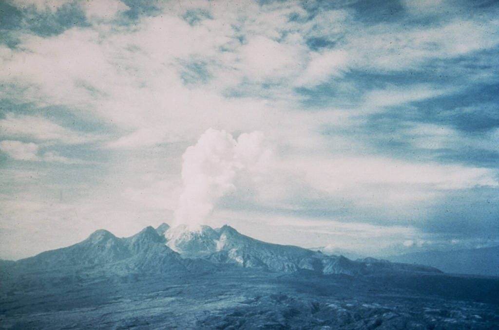
Scientists from the Rabaul Volcano Observatory carried out a 4-day investigation at Lamington and concluded that there was no new volcanic activity. For the previous 3-4 weeks rumors had been circulating that Lamington was active, with reports of "fire" and "smoke" emanating from the volcano, felt earthquakes, and volcanic noises.
Source: Rabaul Volcano Observatory (RVO) via the Darwin Volcanic Ash Advisory Center
Mild vapor emission and earthquakes through March 2006
Lamington has continued the trend of relative quiet during mid-January to the end of March 2006. Consistent reporting has been difficult due to overcast weather. Small volumes of thin white vapor were released during this time. No audible noises or glow were recorded. High frequency earthquakes continued to be recorded. The highest total was 25 recorded on 18 February.
Information Contacts: Ima Itikarai and Herman Patia, Rabaul Volcano Observatory (RVO), P.O. Box 386, Rabaul, Papua New Guinea.
2002: April
Scientists from the Rabaul Volcano Observatory carried out a 4-day investigation at Lamington and concluded that there was no new volcanic activity. For the previous 3-4 weeks rumors had been circulating that Lamington was active, with reports of "fire" and "smoke" emanating from the volcano, felt earthquakes, and volcanic noises.
Source: Rabaul Volcano Observatory (RVO) via the Darwin Volcanic Ash Advisory Center
The Darwin VAAC stated on 24 April that reports of an eruption at Lamington on 22 April were false. Based on information from Geoscience Australia and satellite imagery, the Darwin VAAC originally reported that an E-drifting ash cloud from Lamington seemed to be evident on satellite imagery on 22 April at 1741. Thunderstorms near the volcano made it difficult to locate possible ash on satellite imagery. On 23 April at 1135 a flight service reported that no volcanic activity was observed at Lamington. A team from the Rabaul Volcano Observatory is investigating rumors of activity at the volcano.
Source: Darwin Volcanic Ash Advisory Centre (VAAC)
Reports are organized chronologically and indexed below by Month/Year (Publication Volume:Number), and include a one-line summary. Click on the index link or scroll down to read the reports.
Long-term decline in thermal activity
"A brief aerial and ground inspection was carried out at the summit on 12 October. Most of the 1951 summit crater dome had a dense canopy of vegetation, broken only by a number of thermal areas scattered around the summit. Weak vapour emission was noted from fumaroles. Temperatures were measured in one of the larger thermal areas; the highest reading was 93°C. In 1973, the highest temperature recorded in the same thermal area was 362°C. This temperature decrease is consistent with the visual impression of declining activity. Seismic surveillance from a station near the summit was suspended in 1989; measurements in November revealed no volcanic seismicity."
Information Contacts: B. Talai and C. McKee, RVO.
Big eruption's 50th anniversary passed amid continued slumber
The instrumented, yet now-quiet Mount Lamington resides on the SE peninsula of the main island of Papua New Guinea. It lies roughly across that peninsula from the capital city of Port Moresby and 40 km inland from the Solomon Sea. Lamington's summit contains ragged peaks and a U-shaped crater open to the N. The volcano is ~21 km SSW of Popondetta Town, the provincial center for Oro Province. Lamington does not erupt frequently like Manam and Ulawun, but had a single historical eruption of such magnitude that, if repeated, could be catastrophic for the more than 30,000 people who live nearby.
About fifty years ago, on 21 January 1951, a major explosive eruption at Lamington killed ~3,000 people, the most of all historical volcanic eruptions in Papua New Guinea. Before the 1951 eruption, Lamington was not known to be a volcano. The group of mountains where the volcano stands was covered in thick jungle and there were no stories to suggest that eruptions had occurred before. As documented in a classic study by Taylor (1958), the paroxysmal eruption was not a sudden happening, but had begun several days earlier when nearby residents started to see changes in the summit area. The pyroclastic flow from the eruption devastated an area of ~200 km2, forming a radial pattern around the volcano that extended slightly farther on the N side. Two photos illustrating aspects of the eruption appear in figures 1 and 2. One of the hallmarks of Taylor's study was his well-developed timelines that clearly stated the sequence of events.
Hastily arranged monitoring commenced immediately after the 1951 eruption but only operated during the active phase of the eruption. A more permanent monitoring program began in 1970 with the installation of a seismograph. In October 1996, a modern seismic station and an electronic tiltmeter were installed on Lamington.
Currently RVO has permanent, smaller observatories at Lamington, as well as at Ulawun, Langila, Karkar, Manam, and Esa'ala. Each is equipped with a recording seismograph. In addition, the stations at Lamington, Ulawun, Karkar, and Manam contain real-time high-frequency data-transmission systems that allow RVO volcanologists to remotely monitor those sites.
Since the 1951 eruption, seismic activity has been absent to rare. Seismic records on 21 December 2000 and 17 February 2001 showed several hours of very high seismicity, but it was difficult to ascertain the cause.
Reference. Taylor, G.A.M., 1958 (2nd ed., 1983), The 1951 eruption of Mount Lamington, Papua: BMR (Australia) Bulletin 38, Australian Government publishing service, Canberra (ISBN 0 644 01969 7; ISSN 0084-7089).
Information Contacts: Ima Itikarai, Rabaul Volcano Observatory (RVO), P.O. Box 386, Rabaul, Papua New Guinea.
Rumors of volcanism in April 2002 were false
During most of April 2002, residents of Popondetta Town, ~21 km NNE of Lamington, and villages near the volcano were besieged by rumors of the volcano showing signs of renewed activity. Later investigations found no evidence of volcanism. Some of the rumors included fire and "smoke" from the volcano, felt earthquakes, and noises. As a result of the rumors, a couple of schools closed, some residents buried their belongings for safekeeping, and others prepared to evacuate. At the time it was difficult for the Rabaul Volcano Observatory (RVO) to confirm or deny the reports because the monitoring equipment for Lamington had not been operating since October 2001.
Based on information from Geoscience Australia and satellite imagery, the Darwin VAAC reported that an E-drifting ash cloud from Lamington seemed to be evident on satellite imagery on 22 April at 1711. The height of the cloud was not known due to thunderstorms in the area making it difficult to detect ash. However, on 23 April at 1105 a flight service reported that no volcanic activity was evident at Lamington. By 26 April Darwin VAAC had concluded that the suspicious cloud was not related to volcanism.
Investigations by the Geological Survey of PNG (RVO and PMGO) of the Department of Mining were carried out during 21-25 April (courtesy of funding from AusAID). On 28 April 2002, RVO reported that, after 3-4 weeks of rumor and speculation suggesting Lamington was showing signs of renewed volcanic activity, none had occurred. Monitoring equipment was restored during the trip, and seismic recordings during those few days showed no seismicity. A very brief aerial inspection of the summit area showed no concrete evidence of renewed volcanic activity. There were no changes in the topographical features or vegetation to indicate recent activity. Small amounts of vapor were being emitted from a few fumarole locations, but that activity was not a new development. There have been no additional reports of unusual activity or increased seismicity through February 2003.
Information Contacts: Ima Itikarai, Rabaul Volcano Observatory (RVO), P.O. Box 386, Rabaul, Papua New Guinea.
High-frequency earthquakes began in early July
The Rabaul Volcanological Observatory reported that Lamington remained quiet over the period 25 June-9 October 2003. Vapor emissions were difficult to observe because of the distance to the observation point, but on a few clear days very small volumes of thin white vapor were seen in the summit area. The report also noted that high-frequency volcano-tectonic-like earthquakes began in early July at a rate of up to five events per day and continued into early October. This is the first time since the seismic station was re-established in 1997 that these types of earthquakes have been recorded in significant numbers over a short period of time.
Information Contacts: Ima Itikarai, Rabaul Volcanological Observatory, P.O. Box 386, Rabaul, Papua New Guinea.
Available observations suggest quiet prevails
Lamington remained quiet during 10 October-14 December 2003. Cloud cover over the summit area made visual observations difficult, and the earthquake recorder did not function due to technical problems. Although it was difficult to make a reliable prognosis based on very limited data and information, Rabaul Volcano Observatory expected Lamington to remain quiet.
Information Contacts: Ima Itikarai, Rabaul Volcano Observatory (RVO), P.O. Box 386, Rabaul, Papua New Guinea.
Mild vapor emission and earthquakes through March 2006
Lamington has continued the trend of relative quiet during mid-January to the end of March 2006. Consistent reporting has been difficult due to overcast weather. Small volumes of thin white vapor were released during this time. No audible noises or glow were recorded. High frequency earthquakes continued to be recorded. The highest total was 25 recorded on 18 February.
Information Contacts: Ima Itikarai and Herman Patia, Rabaul Volcano Observatory (RVO), P.O. Box 386, Rabaul, Papua New Guinea.
This compilation of synonyms and subsidiary features may not be comprehensive. Features are organized into four major categories: Cones, Craters, Domes, and Thermal Features. Synonyms of features appear indented below the primary name. In some cases additional feature type, elevation, or location details are provided.
Synonyms |
| Higaturu |
|
|
||||||||||||||||||||||||||
There is data available for 3 confirmed Holocene eruptive periods.
1951 Jan 17 - 1956 Jul 2 ± 182 days Confirmed Eruption VEI: 4
| Episode 1 | Eruption | |||||||||||||||||||||||||||||||||||||||||||||||||||||||||||||||||||||||||||||||||||||||||||||||||||||||||||||||||||
|---|---|---|---|---|---|---|---|---|---|---|---|---|---|---|---|---|---|---|---|---|---|---|---|---|---|---|---|---|---|---|---|---|---|---|---|---|---|---|---|---|---|---|---|---|---|---|---|---|---|---|---|---|---|---|---|---|---|---|---|---|---|---|---|---|---|---|---|---|---|---|---|---|---|---|---|---|---|---|---|---|---|---|---|---|---|---|---|---|---|---|---|---|---|---|---|---|---|---|---|---|---|---|---|---|---|---|---|---|---|---|---|---|---|---|---|
| 1951 Jan 17 - 1956 Jul 2 ± 182 days | Evidence from Observations: Reported | ||||||||||||||||||||||||||||||||||||||||||||||||||||||||||||||||||||||||||||||||||||||||||||||||||||||||||||||||||
|
List of 21 Events for Episode 1
| |||||||||||||||||||||||||||||||||||||||||||||||||||||||||||||||||||||||||||||||||||||||||||||||||||||||||||||||||||
4850 BCE ± 300 years Confirmed Eruption
| Episode 1 | Eruption | Dea Ash | |||||||||||||||||||
|---|---|---|---|---|---|---|---|---|---|---|---|---|---|---|---|---|---|---|---|---|
| 4850 BCE ± 300 years - Unknown | Evidence from Isotopic: 14C (uncalibrated) | |||||||||||||||||||
|
List of 2 Events for Episode 1 at Dea Ash
| ||||||||||||||||||||
5980 BCE ± 300 years Confirmed Eruption
| Episode 1 | Eruption | Owalama Ash | |||||||||||||||||||
|---|---|---|---|---|---|---|---|---|---|---|---|---|---|---|---|---|---|---|---|---|
| 5980 BCE ± 300 years - Unknown | Evidence from Isotopic: 14C (uncalibrated) | |||||||||||||||||||
|
List of 2 Events for Episode 1 at Owalama Ash
| ||||||||||||||||||||
There is no Deformation History data available for Lamington.
There is no Emissions History data available for Lamington.
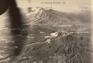 The Hydrographers Range, seen here from the W, is a forested, deeply dissected volcanic massif extending from the E margin of Mount Lamington (lower right) to the northern coast of Papua New Guinea. Most activity took place during the Pleistocene, but well-preserved scoria cones and craters suggest that some Holocene activity occurred. This 1947 photo was taken prior to Lamington's catastrophic eruption in 1951.
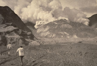 Members of a scientific team approach the crater of Mount Lamington through the avalanche valley on 11 February 1951. Explosions occurred from a vent behind the new lava dome growing in the summit crater produce gas and ash plumes. Growth of the lava dome began soon after the catastrophic 21 January explosive eruption. At the time of this photo, the smooth-surfaced lava dome was uplifting the floor of the new crater. The dome eventually grew to the height of the crater rim.
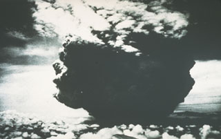 This photograph of the catastrophic eruption of 21 January 1951 was taken by the pilot flying from Port Moresby to Rabaul. From about 40 km NW, the pilot observed this ash plume rising to a height of about 13 km within two minutes. Shortly afterwards, the cloud expanded horizontally away from the volcano as devastating pyroclastic flows and surges swept radially up to 12 km from the crater.
 On 19 August 1951 this large lava spine towered about 130 m above the surface of the growing lava dome. Growth of the spine had ceased at about this time. Extrusion and destruction of lava spines occurred frequently during the five-year long period of lava dome growth.
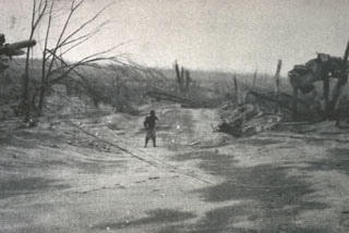 The vehicle to the right was suspended 3 m above the ground between the tops of two broken trees by the devastating pyroclastic surges of the 21 January 1951 eruption of Mount Lamington. The vehicle was located in the village of Higaturu, 10 km N of the volcano. Velocities of the pyroclastic surges were estimated to be in excess of 120 km per hour. The high-temperature surges destroyed the village, removing houses from their foundations and demolishing a steel-framed hospital building.
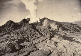 The first historical eruption of Lamington was in 1951, prior to which it was not known to be a volcano by those living on its flanks. Following continuous light ash emission beginning on 17 January the paroxysmal eruption on 21 January produced pyroclastic flows and surges that swept all sides of the volcano to a maximum distance of 12 km to the north, killing nearly 3,000 people. This 5 February photo shows the devastated northern flanks and a plume rising from a growing lava dome in the new crater. Slow dome growth ended in 1956.
 Mount Lamington, seen here from the north in late 1951, has a 1.3-km-wide summit crater containing a lava dome. Prior to its disastrous eruption in 1951, the forested peak had not been recognized as a volcano. The 1951 eruption produced pyroclastic flows and surges that devastated all sides of the volcano, killing nearly 3,000 people. The eruption concluded with growth of a 560-m-high lava dome in the summit crater.
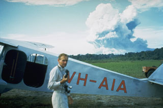 Australian volcanologist Tony Taylor in front of Mount Lamington, which is erupting in the distance on 5 February 1951. Taylor investigated the activity at Lamington through the course of the eruption.
 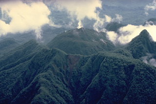 Nearly three decades after its catastrophic eruption in 1951, Mount Lamington is mantled with dense vegetation. This aerial view from the south shows the rounded summit lava dome (center) that was emplaced during 1951-56 in a horseshoe-shaped crater breached to the north. The arcuate ridge in the foreground and the sharp peak at the right mark the rim of 1951 crater.
Maps are not currently available due to technical issues.
There are no samples for Lamington in the Smithsonian's NMNH Department of Mineral Sciences Rock and Ore collection.
| Copernicus Browser | The Copernicus Browser replaced the Sentinel Hub Playground browser in 2023, to provide access to Earth observation archives from the Copernicus Data Space Ecosystem, the main distribution platform for data from the EU Copernicus missions. |
| MIROVA | Middle InfraRed Observation of Volcanic Activity (MIROVA) is a near real time volcanic hot-spot detection system based on the analysis of MODIS (Moderate Resolution Imaging Spectroradiometer) data. In particular, MIROVA uses the Middle InfraRed Radiation (MIR), measured over target volcanoes, in order to detect, locate and measure the heat radiation sourced from volcanic activity. |
| MODVOLC Thermal Alerts | Using infrared satellite Moderate Resolution Imaging Spectroradiometer (MODIS) data, scientists at the Hawai'i Institute of Geophysics and Planetology, University of Hawai'i, developed an automated system called MODVOLC to map thermal hot-spots in near real time. For each MODIS image, the algorithm automatically scans each 1 km pixel within it to check for high-temperature hot-spots. When one is found the date, time, location, and intensity are recorded. MODIS looks at every square km of the Earth every 48 hours, once during the day and once during the night, and the presence of two MODIS sensors in space allows at least four hot-spot observations every two days. Each day updated global maps are compiled to display the locations of all hot spots detected in the previous 24 hours. There is a drop-down list with volcano names which allow users to 'zoom-in' and examine the distribution of hot-spots at a variety of spatial scales. |
|
WOVOdat
Single Volcano View Temporal Evolution of Unrest Side by Side Volcanoes |
WOVOdat is a database of volcanic unrest; instrumentally and visually recorded changes in seismicity, ground deformation, gas emission, and other parameters from their normal baselines. It is sponsored by the World Organization of Volcano Observatories (WOVO) and presently hosted at the Earth Observatory of Singapore.
GVMID Data on Volcano Monitoring Infrastructure The Global Volcano Monitoring Infrastructure Database GVMID, is aimed at documenting and improving capabilities of volcano monitoring from the ground and space. GVMID should provide a snapshot and baseline view of the techniques and instrumentation that are in place at various volcanoes, which can be use by volcano observatories as reference to setup new monitoring system or improving networks at a specific volcano. These data will allow identification of what monitoring gaps exist, which can be then targeted by remote sensing infrastructure and future instrument deployments. |
| Volcanic Hazard Maps | The IAVCEI Commission on Volcanic Hazards and Risk has a Volcanic Hazard Maps database designed to serve as a resource for hazard mappers (or other interested parties) to explore how common issues in hazard map development have been addressed at different volcanoes, in different countries, for different hazards, and for different intended audiences. In addition to the comprehensive, searchable Volcanic Hazard Maps Database, this website contains information about diversity of volcanic hazard maps, illustrated using examples from the database. This site is for educational purposes related to volcanic hazard maps. Hazard maps found on this website should not be used for emergency purposes. For the most recent, official hazard map for a particular volcano, please seek out the proper institutional authorities on the matter. |
| IRIS seismic stations/networks | Incorporated Research Institutions for Seismology (IRIS) Data Services map showing the location of seismic stations from all available networks (permanent or temporary) within a radius of 0.18° (about 20 km at mid-latitudes) from the given location of Lamington. Users can customize a variety of filters and options in the left panel. Note that if there are no stations are known the map will default to show the entire world with a "No data matched request" error notice. |
| UNAVCO GPS/GNSS stations | Geodetic Data Services map from UNAVCO showing the location of GPS/GNSS stations from all available networks (permanent or temporary) within a radius of 20 km from the given location of Lamington. Users can customize the data search based on station or network names, location, and time window. Requires Adobe Flash Player. |
| DECADE Data | The DECADE portal, still in the developmental stage, serves as an example of the proposed interoperability between The Smithsonian Institution's Global Volcanism Program, the Mapping Gas Emissions (MaGa) Database, and the EarthChem Geochemical Portal. The Deep Earth Carbon Degassing (DECADE) initiative seeks to use new and established technologies to determine accurate global fluxes of volcanic CO2 to the atmosphere, but installing CO2 monitoring networks on 20 of the world's 150 most actively degassing volcanoes. The group uses related laboratory-based studies (direct gas sampling and analysis, melt inclusions) to provide new data for direct degassing of deep earth carbon to the atmosphere. |
| Large Eruptions of Lamington | Information about large Quaternary eruptions (VEI >= 4) is cataloged in the Large Magnitude Explosive Volcanic Eruptions (LaMEVE) database of the Volcano Global Risk Identification and Analysis Project (VOGRIPA). |
| EarthChem | EarthChem develops and maintains databases, software, and services that support the preservation, discovery, access and analysis of geochemical data, and facilitate their integration with the broad array of other available earth science parameters. EarthChem is operated by a joint team of disciplinary scientists, data scientists, data managers and information technology developers who are part of the NSF-funded data facility Integrated Earth Data Applications (IEDA). IEDA is a collaborative effort of EarthChem and the Marine Geoscience Data System (MGDS). |