
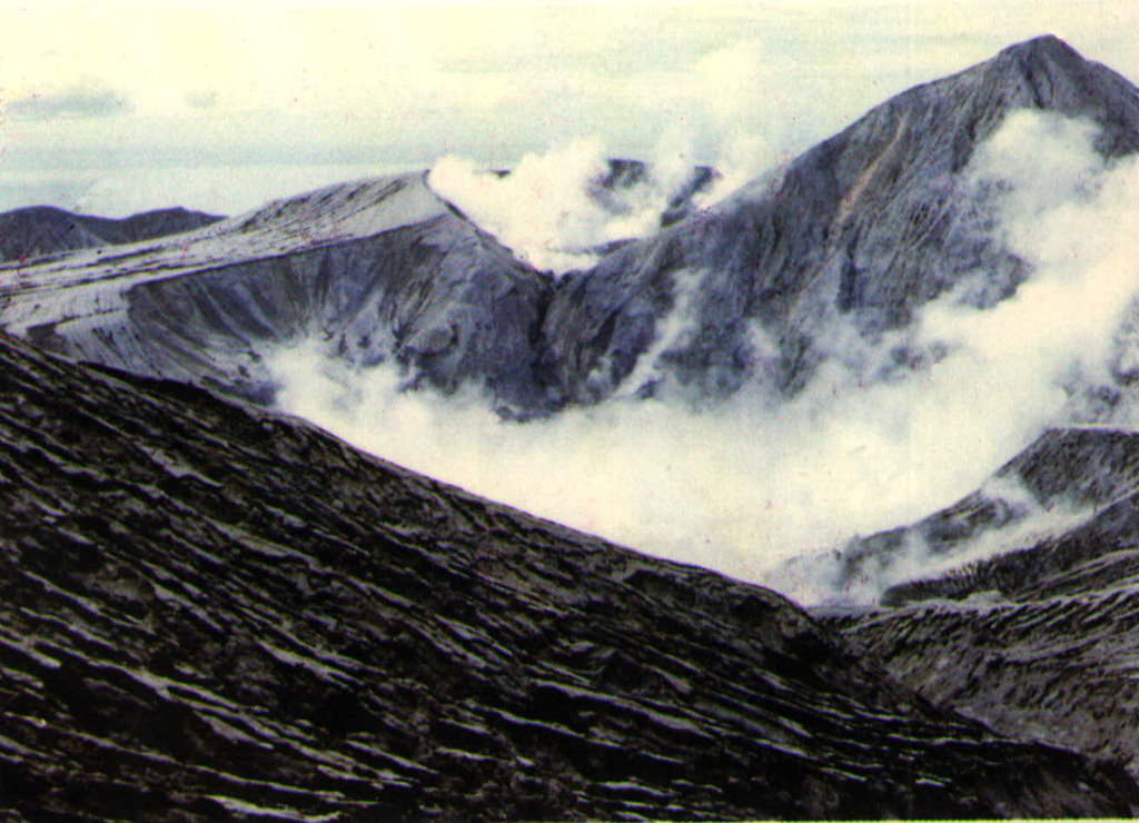
PVMBG reported that seismicity at Colo declined during 1 September-25 October; 1-7 shallow-volcanic earthquakes and 1-3 volcanic earthquakes were recorded per day, which were rates similar to those recorded before a seismic increase in June. The Alert Level was lowered to 1 (on a scale of 1-4) on 26 October, and residents and tourists were warned not to approach the crater.
Source: Pusat Vulkanologi dan Mitigasi Bencana Geologi (PVMBG, also known as CVGHM)
14 July plume may have been weather cloud
Although a NOAA 10 weather satellite image on 14 July showed a cloud that extended ~200 km from the vicinity of Una Una, no reports were received of an eruption from the island, uninhabited since residents were evacuated before the paroxysmal explosion of 23 July 1983.
Yosihiro Sawada inspected 14-15 July imagery from the GMS weather satellite. By 0800 on 14 July, less than an hour after the NOAA 10 image, the cloud retained a plume-like structure, but its origin was several tens of kilometers W of Una Una. An infrared image 24 hours later showed a chain of weather clouds extending SW from several sources just W of Una Una. On the image returned three hours later, these clouds had combined to form a plume-like feature similar to the one seen the previous day. This evidence, and the absence of a reported eruption, suggested that weather clouds may have produced the 14 July plume.
Information Contacts: Y. Sawada, JMA.
PVMBG reported that seismicity at Colo declined during 1 September-25 October; 1-7 shallow-volcanic earthquakes and 1-3 volcanic earthquakes were recorded per day, which were rates similar to those recorded before a seismic increase in June. The Alert Level was lowered to 1 (on a scale of 1-4) on 26 October, and residents and tourists were warned not to approach the crater.
Source: Pusat Vulkanologi dan Mitigasi Bencana Geologi (PVMBG, also known as CVGHM)
PVMBG reports that seismicity significantly increased on 8 June, particularly volcanic and shallow-volcanic earthquakes; 12 volcanic earthquakes were recorded on 22 June (previously, 1-5 events per day had been recorded), and there were 11 shallow volcanic earthquakes on 23 June (previously, 1-8 events per day had been recorded). On 24 June the Alert Level was raised to 2 (on a scale of 1-4). However, observers at the Colo Volcano Observation Post in the Wakai village did not see plumes during April-23 June. Residents and tourists were warned not to approach the volcano within a radius of 1.5 km.
Source: Pusat Vulkanologi dan Mitigasi Bencana Geologi (PVMBG, also known as CVGHM)
Reports are organized chronologically and indexed below by Month/Year (Publication Volume:Number), and include a one-line summary. Click on the index link or scroll down to read the reports.
Pyroclastic flows devastate island; clouds to stratosphere; evacuations prevent large death toll
An explosive eruption produced pyroclastic flows that destroyed most homes, vegetation, and animal life on 40 km2 Una Una Island and probably injected tephra into the stratosphere. Initial activity prompted evacuation of everyone on the island before the devastating explosions.
The eruption was preceded by seismicity that increased from 9-11 felt events/day on 8 July to 30-40/day on 15 July. The number of recorded events was 33 on 14 July, increasing the following days to 49, 53, and 73 then to an average of more than 90/day 18-21 July. The strongest earthquake was felt 400 km away on 18 July. That morning, a 1-km column of ash and incandescent material was ejected. AFP reported that a strong explosion occurred 19 July, and thick gray clouds containing incandescent tephra were visible from Ampana, more than 100 km to the S, the next day.
By the 20th, almost all houses and buildings in the eight villages near the volcano had been destroyed and nearly half of the residents of the island had been evacuated. All had left by the time of a major explosion on 21 July at 1623 that subjected 80% of the island to temperatures of up to 200°C. Tephra as large as 5-10 cm in diameter fell near a VSI observation vessel and the monitoring team reported flames on parts of the island. A government geologist estimated that all 700,000 coconut trees and all livestock on the island must have been burned, probably by pyroclastic flows. Ash darkened much of the region. People in Falu, 250 km away, were forced to protect themselves from ashfall until late 23 July. A VSI field party arriving on the island 22 July at 0100 felt ten earthquakes during their 15-hour stay and observed a 1.5-km eruption column at 1649.
On 23 July at 2055, a British Airways jet (en route from Singapore to Perth) flying at 10.6 km altitude encountered an eruption cloud at 1.4°S, 120.71°E, about 150 km S of Una Una (figure 1). Pilots noted a volcanic smell, lack of visibility, and St. Elmo's Fire around the windshield. The aircraft returned immediately to Singapore and suffered no damage. On 24 July at 1930, a satellite image showed a cloud about 120 km wide, extending about 600 km S from Una Una. Earlier in the eruption, weather clouds had obscured the Una Una area. Press reports quoted a local government official who said that 80% of the island was covered by volcanic clouds on 24 July, burning vegetation and destroying trees. On 26 July at 0000, the Japanese GMS satellite showed what appeared to be a dense eruption column rising from the island. On the next image, two hours later, a fan-shaped plume was visible, probably in or near the stratosphere. High-altitude material was blowing SW and W, while low and mid-level debris was drifting slowly S to SSE.
On 28 July at 0200 the GMS satellite showed a small plume over the island. By 0500 a plume about 60 km wide extended about 200 km WSW from the volcano. The plume appeared denser at 0800 and by 1100 vigorous activity fed a cloud that reached 118 E and at least 13.5 km altitude. At 1400 the plume stretched about 500 km to the WSW and was very dense within 250 km of the volcano. Temperatures and wind directions at the tropopause (15 km altitude) were consistent with the plume's direction of movement and coldest temperature (-76°C) from a NOAA 7 image at 1430 (figure 2). By the next image, at 2000, the plume had dissipated. The GMS satellite showed the beginning of another eruptive episode on 30 July at 1630. At 2000, a NOAA 7 image contained a WSW-drifting plume, similar to the one on 28 July but not as spectacular. Feeding of this plume was continuing at 2300; it drifted SW, then W toward Sulawesi. It extended from the volcano about 200 km to 1.5°S, 119.5°E on 31 July at 0200, but was dissipating three hours later. At 2000 an image showed what appeared to be an eruption column, but little activity was visible three hours later.
Another explosive episode first appeared on the imagery 2 August at 0500. Before activity ended at 1700, a plume had moved about 200 km to theSW and reached roughly 9-12 km altitude. A dense eruption column appeared over the island 3 August at 0000 and extended roughly 120 km to the W and SW two hours later. The plume was relatively diffuse and appeared to have reached only the mid-troposphere. Satellite images indicated that another explosion started 4 August at about 1000, feeding a plume that moved about 350 km to the NNW. The different direction of drift was the result of a weather change; this plume probably remained in the troposphere. AFP reported an eruption on 9 August at 0835 that ejected a gray plume to 3 km. No activity was evident on satellite images until 12 August at 0130, when a plume was observed that was not visible two hours earlier. At 0300, NOAA 7 data showed a dense plume, similar to that of 28 July, extending about 300 km SW to central Sulawesi.
Information Contacts: A. Sudradjat, VSI; N. Banks, HVO; M. Matson, J. Hawkins, O. Karst, and S. Kusselson, NOAA/NESDIS; AFP; Antara News Agency, Jakarta; UPI.
Continued explosive activity seen on satellite images; numerous magnitude 5 earthquakes
Satellite images continued to show occasional eruption plumes through late August. After the 12 August plume described last month, activity was next observed on an image from the GMS satellite on 22 August at 1400, when a very small fairly bright area was present directly over the island, a feature typical of the initial stages of an explosive episode. This event developed rapidly with a NOAA 7 image 35 minutes later showing a bright plume extending about 60 km to the W. By 1700 (GMS data), it had moved about 120 km W from the volcano, and its leading edge had just reached the coast of Sulawesi. On the next image, at 2000, feeding from the volcano appeared to have ended and the plume was dissipating to the W. On 26 August at 1100, a GMS image showed a bright, newly-ejected plume about 40 km wide that appeared to have reached the tropopause. At 1400, a very dense high-level cloud about 80 km wide had spread W then SW about 250 km, but on a NOAA 7 image 1 hour later the cloud appeared to be dispersing and the eruption had clearly ceased by the next GMS image at 1700. On 29 August, GMS imageryshowed the beginning of an explosive episode at about 1930. By midnight, a moderately dense plume extended WSW along the equator, then turned abruptly to the SSW, reaching 120°E at 1-2°S. On the next image, at 0500, feeding from the volcano had stopped and the plume was nearly dissipated.
Government officials noted that several villages [were] completely destroyed by the eruption and that all of the island's coconut trees had been killed. All of the people living on Una Una were evacuated before the devastating explosions 23 July. Officials anticipated that it would be several years before the island would again be habitable, so residents have been resettled on other islands until they can return.
The WWSSN noted 66 events in the vicinity of Una Una beginning late 16 July. No earthquakes smaller than M 4.5 were tabulated, and most magnitudes were between 4.8 and 5.4. Of these, the 21 recorded by 20 or more stations had a mean epicenter of 0.09°S, 121.70°E (standard deviations for both latitude and longitude, 0.05°), about 15 km NE of the volcano. Depths of the same 21 events avaraged 55 km (standard deviation 7.5 km). Earthquakes recorded by the WWSSN had become less frequent by the time of the largest explosion 23 July; few were recorded after 26 July and none after 1 August. Other events in the region included single M 5.0-5.3 shocks on 27, 28, and 31 July, about 200 km ENE of Una Una at roughly 40 km depth; and M 5.5 and 5.1 earthquakes 20 and 31 July at depths of 299 and 272 km, 300 km WNW of the volcano.
Information Contacts: M. Matson, J. Hawkins, and S. Kusselson, NOAA/NESDIS; NEIC; Antara News Agency, Jakarta.
Satellite observations of July-August eruption clouds
Since late August, no explosions have been reported by ground observers or seen on satellite imagery. Yosihiro Sawada searched all July and August images from the GMS satellite and provided table 1.
Table 1. Una Una eruption cloud data extracted from GMS satellite images. Data are tentative; some apparent plumes may have been weather clouds. Times are the beginnings of image scans, which are completed in about 25 minutes. Images are returned 14 times/day at intervals ranging from 30 minutes to 3 hours. New explosions are indicated in the remarks column. Data shown in parentheses are for plumes that are detached from the volcano because explosive activity had (apparently) stopped. A new plume was sometimes ejected before remnants of the previous explosive pulse had dissipated; dimensions of the old plume are then listed in parentheses below data on the new activity. Coldest temperatures at the tops of plumes are shown. Courtesy of Yosihiro Sawada.
| Date | Time | Length (km) | Width (km) | Temp (°C) | Comment |
| 23 Jul 1983 | 1631 | 100 | 90 | -74 | -- |
| 23 Jul 1983 | 1801 | -- | -- | -76 | -- |
| 23 Jul 1983 | 1831 | 320 | 200 | -- | -- |
| 23 Jul 1983 | 1931 | 560 | 180 | -- | -- |
| 25 Jul 1983 | 2331 | 30 | 30 | -70 | New explosion |
| 26 Jul 1983 | 0131 | 210 | 160 | -- | -- |
| 26 Jul 1983 | 0431 | (520) | (160) | -- | -- |
| 27 Jul 1983 | 1931 | 60 | 20 | -- | New explosion |
| 28 Jul 1983 | 0131 | 160 | 20 | -- | -- |
| 28 Jul 1983 | 0431 | 170 | 50 | -- | -- |
| 28 Jul 1983 | 0631 | 290 | 70 | -- | -- |
| 28 Jul 1983 | 0731 | 260 | 40 | -- | -- |
| 28 Jul 1983 | 1031 | 500 | 70 | -- | -- |
| 28 Jul 1983 | 1331 | 550 | 60 | -- | -- |
| 28 Jul 1983 | 1631 | 710 | 80 | -- | -- |
| 28 Jul 1983 | 1831 | 650 | 70 | -- | -- |
| 28 Jul 1983 | 1931 | 500 | 30 | -- | -- |
| 28 Jul 1983 | 2331 | (340) | (20) | -- | -- |
| 30 Jul 1983 | 1631 | 80 | 40 | -73 | New explosion |
| 30 Jul 1983 | 1801 | -- | -- | -80 | -- |
| 30 Jul 1983 | 1831 | 260 | 110 | -- | -- |
| 30 Jul 1983 | 1931 | 370 | 120 | -- | -- |
| 30 Jul 1983 | 2331 | 190 (340) | 50 (320) | -- | New explosion |
| 31 Jul 1983 | 0131 | 250 | 130 | -- | -- |
| 31 Jul 1983 | 0431 | (260) | (100) | -- | -- |
| 31 Jul 1983 | 1801 | -- | -- | -70 | New explosion |
| 31 Jul 1983 | 1831 | 60 | 30 | -71 | -- |
| 31 Jul 1983 | 1901 | -- | -- | -71 | -- |
| 31 Jul 1983 | 1931 | 160 | 50 | -71 | -- |
| 31 Jul 1983 | 2331 | (150) | (80) | -- | -- |
| 01 Aug 1983 | 0131 | (160) | (110) | -- | -- |
| 01 Aug 1983 | 0431 | (130) | (50) | -- | -- |
| 02 Aug 1983 | 0431 | 70 | 50 | -72 | -- |
| 02 Aug 1983 | 0601 | -- | -- | -65 | -- |
| 02 Aug 1983 | 0631 | 160 | 70 | -63 | -- |
| 02 Aug 1983 | 0701 | -- | -- | -72 | -- |
| 02 Aug 1983 | 0731 | 240 | 80 | -75 | -- |
| 02 Aug 1983 | 1031 | 420 | 100 | -79 | -- |
| 02 Aug 1983 | 1331 | 50 (340) | 15 (240) | -60 | New explosion |
| 02 Aug 1983 | 1631 | 60 (420) | 20 (320) | -56 | -- |
| 02 Aug 1983 | 1831 | (130) | (20) | -- | -- |
| 02 Aug 1983 | 1931 | (450) | (320) | -- | -- |
| 02 Aug 1983 | 2331 | 80 | 30 | -71 | -- |
| 03 Aug 1983 | 0131 | (120) | (60) | -- | -- |
| 03 Aug 1983 | 0431 | (110) | (20) | -- | -- |
| 03 Aug 1983 | 0631 | (130) | (15) | -- | -- |
| 04 Aug 1983 | 1031 | 80 | 40 | -73 | -- |
| 04 Aug 1983 | 1331 | 150 | 110 | -73 | -- |
| 04 Aug 1983 | 1631 | 190 | 120 | -63 | -- |
| 04 Aug 1983 | 1831 | (190) | (160) | -- | -- |
| 04 Aug 1983 | 1931 | (210) | (130) | -- | -- |
| 04 Aug 1983 | 2331 | 90 | 100 | -79 | New explosion |
| 05 Aug 1983 | 0131 | 170 | 100 | -81 | -- |
| 05 Aug 1983 | 0431 | 280 | 200 | -73 | -- |
| 05 Aug 1983 | 0601 | -- | -- | -61 | -- |
| 05 Aug 1983 | 0631 | 170 | 170 | -60 | -- |
| 05 Aug 1983 | 0701 | -- | -- | -64 | -- |
| 05 Aug 1983 | 0731 | 30 | 30 | -70 | New explosion |
| 05 Aug 1983 | 1031 | 60 | 60 | -61 | -- |
| 05 Aug 1983 | 1331 | 100 | 90 | -63 | -- |
| 05 Aug 1983 | 0131 | 30 | 20 | -64 | -- |
| 06 Aug 1983 | 0131 | 30 | 20 | -64 | New explosion |
| 06 Aug 1983 | 0431 | 110 | 60 | -- | -- |
| 06 Aug 1983 | 0631 | 190 | 90 | -- | -- |
| 06 Aug 1983 | 0731 | 200 | 130 | -- | -- |
| 06 Aug 1983 | 1631 | 60 | 50 | -73 | New explosion |
| 06 Aug 1983 | 1801 | -- | -- | -69 | -- |
| 06 Aug 1983 | 1831 | 110 | 70 | -- | -- |
| 06 Aug 1983 | 1931 | (130) | (80) | -- | -- |
| 07 Aug 1983 | 1331 | 190 | 80 | -75 | New explosion |
| 07 Aug 1983 | 1631 | 320 | 110 | -79 | -- |
| 07 Aug 1983 | 1801 | -- | -- | -77 | -- |
| 07 Aug 1983 | 1831 | 190 | 150 | -75 | -- |
| 07 Aug 1983 | 1931 | 240 | 160 | -- | -- |
| 07 Aug 1983 | 2331 | 150 | 70 | -- | -- |
| 08 Aug 1983 | 0131 | (190) | (60) | -- | -- |
| 08 Aug 1983 | 0431 | 30 | 15 | -- | New explosion |
| 08 Aug 1983 | 0631 | 60 | 15 | -- | -- |
| 08 Aug 1983 | 0731 | (70) | (20) | -- | -- |
| 10 Aug 1983 | 0131 | 30 | 20 | -- | (obscure) |
| 10 Aug 1983 | 0431 | 30 | 10 | -- | (obscure) |
| 10 Aug 1983 | 0631 | 50 | 15 | -- | (obscure) |
| 11 Aug 1983 | 1331 | 290 | 80 | -69 | -- |
| 11 Aug 1983 | 1631 | (510) | (110) | -- | -- |
| 11 Aug 1983 | 1831 | (680) | (160) | -- | -- |
| 12 Aug 1983 | 0131 | 140 | 60 | -73 | New explosion |
| 12 Aug 1983 | 0431 | 460 | 100 | -- | -- |
| 22 Aug 1983 | 1331 | 20 | 15 | -- | (obscure) |
| 22 Aug 1983 | 1631 | 150 | 110 | -- | (obscure) |
| 22 Aug 1983 | 1831 | (260) | (110) | -- | -- |
| 22 Aug 1983 | 1931 | (300) | (140) | -- | -- |
| 26 Aug 1983 | 1331 | -- | -- | -- | New explosion; almost circular plume |
| 26 Aug 1983 | 1631 | -- | -- | -- | Cloud detected |
Information Contacts: Y. Sawada, MRI, Tsukuba.
July- August explosion times, plume heights, and photos
A VSI team monitored the eruption from near the island [beginning 23 July, and observed 22 distinct explosions (table 2). Many, but not all of these explosions were detected by satellite (table 1).]
Table 2. Times of Una Una eruption clouds with heights estimated by VSI geologists [23 July-26 August 1983.].
| Date | Time | Plume height (km) |
| 23 Jul 1983 | 1623 | 10 |
| 25-26 Jul 1983 | 2325-0021 | 7.5 |
| 27 Jul 1983 | 0400-0605 | 7.5 |
| 27 Jul 1983 | 1500-2010 | 7 |
| 28 Jul 1983 | 0002-0045 | 8 |
| 28 Jul 1983 | 1630-1730 | 8 |
| 30 Jul 1983 | 1615-? | 6 |
| 01 Aug 1983 | 1834-2000 | 7 |
| 01-02 Aug 1983 | 2130-0230 | 6 |
| 02 Aug 1983 | 0314-0600 | 8 |
| 02 Aug 1983 | 0800-0900 | 8 |
| 02-03 Aug 1983 | 1905-0200 | 5 |
| 04 Aug 1983 | 0915-1100 | 6 |
| 06 Aug 1983 | 1520-? | 6 |
| 07 Aug 1983 | 1100-1900 | 10 |
| 11 Aug 1983 | 1115-1135 | 8 |
| 12 Aug 1983 | 0047-0147 | 9 |
| 18 Aug 1983 | 1013-1240 | 12 |
| 22 Aug 1983 | 1203-? | 8 |
| 24 Aug 1983 | 2148-2220 | 4 |
| 25 Aug 1983 | 1847-2000 | 5.5 |
| 26 Aug 1983 | 1023-1139 | 10 |
Maurice Krafft visited Una Una in mid-Aug. He observed and photographed the 22 Aug explosion (table 2 and figure 3) and pyroclastic flow deposits from previous explosions (figure 4). The entire island had been devastated except for a narrow strip of undamaged vegetation and villages along the E coast.
Further Reference. Katili, J.A., and Sudradjat, A., 1984, The devastating 1983 eruption of Colo volcano, Una Una Island, central Sulawesi, Indonesia: Geologisches Jahrbuch, v. A75, p. 27-47.
Information Contacts: A. Sudradjat, VSI; M. Krafft, Cernay.
Plume seen on satellite imagery
Imagery from the NOAA 10 polar orbiting weather satellite showed a plume that extended S then W ~200 km from Una Una on 14 July at 0708. VSI could not confirm that an eruption had occurred.
Information Contacts: W. Gould, NOAA/NESDIS; VSI.
14 July plume may have been weather cloud
Although a NOAA 10 weather satellite image on 14 July showed a cloud that extended ~200 km from the vicinity of Una Una, no reports were received of an eruption from the island, uninhabited since residents were evacuated before the paroxysmal explosion of 23 July 1983.
Yosihiro Sawada inspected 14-15 July imagery from the GMS weather satellite. By 0800 on 14 July, less than an hour after the NOAA 10 image, the cloud retained a plume-like structure, but its origin was several tens of kilometers W of Una Una. An infrared image 24 hours later showed a chain of weather clouds extending SW from several sources just W of Una Una. On the image returned three hours later, these clouds had combined to form a plume-like feature similar to the one seen the previous day. This evidence, and the absence of a reported eruption, suggested that weather clouds may have produced the 14 July plume.
Information Contacts: Y. Sawada, JMA.
This compilation of synonyms and subsidiary features may not be comprehensive. Features are organized into four major categories: Cones, Craters, Domes, and Thermal Features. Synonyms of features appear indented below the primary name. In some cases additional feature type, elevation, or location details are provided.
Synonyms |
| Una Una | Oena Oena | Nangoena | Tjolo, Gunung | Belerang, Gunung |
|
|
||||||||||||||||||||||||||
There is data available for 3 confirmed Holocene eruptive periods.
1983 Jul 18 - 1983 Dec 16 ± 15 days Confirmed Eruption VEI: 4
| Episode 1 | Eruption | Gunung Colo | ||||||||||||||||||||||||||||||||||||||||||||||||||||||||||||||||||||||||||||||||||||
|---|---|---|---|---|---|---|---|---|---|---|---|---|---|---|---|---|---|---|---|---|---|---|---|---|---|---|---|---|---|---|---|---|---|---|---|---|---|---|---|---|---|---|---|---|---|---|---|---|---|---|---|---|---|---|---|---|---|---|---|---|---|---|---|---|---|---|---|---|---|---|---|---|---|---|---|---|---|---|---|---|---|---|---|---|---|
| 1983 Jul 18 - 1983 Dec 16 ± 15 days | Evidence from Observations: Reported | ||||||||||||||||||||||||||||||||||||||||||||||||||||||||||||||||||||||||||||||||||||
| Phreatic eruptions began 18 July 1983. Residents were evacuated prior to the paroxysmal eruption at 1623 on 23 July, when pyroclastic flows devastated most of the island. Intermittent large explosive eruptions, some with additional pyroclastic flows, continued until 30 August; minor ash eruptions lasted until 10 October (BVE). VSI (1986) reports white and sometimes gray emissions in November and December, presumably from phreatic eruptions. | |||||||||||||||||||||||||||||||||||||||||||||||||||||||||||||||||||||||||||||||||||||
|
List of 15 Events for Episode 1 at Gunung Colo
| |||||||||||||||||||||||||||||||||||||||||||||||||||||||||||||||||||||||||||||||||||||
1938 ± 10 years Confirmed Eruption VEI: 1
| Episode 1 | Eruption | Gunung Colo | |||||||||||||||||||
|---|---|---|---|---|---|---|---|---|---|---|---|---|---|---|---|---|---|---|---|---|
| 1938 ± 10 years - Unknown | Evidence from Observations: Reported | |||||||||||||||||||
| Six small vents (max. 15 m diameter) formed near the summit sometime between 1928 and 1948, probably due to phreatic eruptions (Katili et al., 1963). | ||||||||||||||||||||
|
List of 2 Events for Episode 1 at Gunung Colo
| ||||||||||||||||||||
1898 May 2 - 1900 (?) Confirmed Eruption VEI: 3 (?)
| Episode 1 | Eruption | Gunung Colo | |||||||||||||||||||||||||||||||||||||||||||||||||
|---|---|---|---|---|---|---|---|---|---|---|---|---|---|---|---|---|---|---|---|---|---|---|---|---|---|---|---|---|---|---|---|---|---|---|---|---|---|---|---|---|---|---|---|---|---|---|---|---|---|---|
| 1898 May 2 - 1900 (?) | Evidence from Observations: Reported | |||||||||||||||||||||||||||||||||||||||||||||||||
| Earthquakes beginning on 10 April 1898 preceded the first and most powerful explosions on 2 May. Following the initial explosive phase during 2-6 May, lighter ashfall was reported intermittently in June and July, and almost continuously in August and October. The eruption lasted until 1899 (Sapper, 1917) or 1900 (CAVW; Katili and Sudradjat, 1984). The central cone must have formed between 1898 and 1900 (Katili and Sudradjat, 1984). Sapper (1917) indicates that the volume estimate may be an order of magnitude larger. | ||||||||||||||||||||||||||||||||||||||||||||||||||
|
List of 8 Events for Episode 1 at Gunung Colo
| ||||||||||||||||||||||||||||||||||||||||||||||||||
There is no Deformation History data available for Colo.
There is data available for 1 emission periods. Expand each entry for additional details.
| Start Date: 1983 Jul 24 | Stop Date: 1983 Jul 24 | Method: Satellite (Nimbus-7 TOMS) |
| SO2 Altitude Min: 15 km | SO2 Altitude Max: 15 km | Total SO2 Mass: 200 kt |
Data Details
| Date Start | Date End | Assumed SO2 Altitude | SO2 Algorithm | SO2 Mass |
| 19830724 | 15.0 | 200.000 |
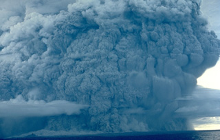 A powerful eruption column rises above Colo volcano on August 22, 1983, and pyroclastic flows sweep to the coast on almost all sides of the island. The eruption began on July 18; on July 23, the day after evacuation of the island's 7000 inhabitants had been completed, paroxysmal eruptions similar to the one above devastated the island.
 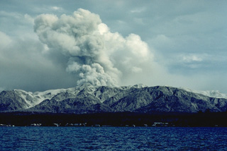 Colo volcano, seen here in eruption in September 1983, forms the isolated island of Una-Una in the Gulf of Tomini, northern Sulawesi. The broad, low island is truncated by a 2-km-wide caldera. Only three eruptions have taken place in historical time, but two of those, in 1898 and 1983, caused extensive devastation over much of the island.
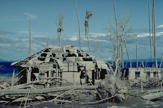 Houses on Una-Una island were devastated by pyroclastic flows from Colo volcano in 1983 that swept over virtually the entire island. All residents had been evacuated by the day before the July 23 paroxysmal eruption.
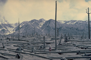 Coconut trees, oriented away from the volcano, were blown down in July 1983 by pyroclastic flows originating from the crater of Colo volcano (left skyline), located in the Gulf of Tomini in northern Sulawesi, Indonesia. Part of an eruption plume can be seen rising from the crater at the extreme left in this August 19, 1983 photo. Pyroclastic flows swept over virtually the entire island only 24 hours all residents had been evacuated.
 Ash mantles the summit of Colo volcano after a powerful explosive eruption in 1983. The volcano forms the isolated island of Una-Una in the middle of the Gulf of Tomini in northern Sulawesi. The broad, low volcano is truncated by a 2-km-wide caldera that contains a small central cone. Only three eruptions have been recorded in historical time. The last eruption, in 1983, produced pyroclastic flows that swept over most of the island shortly after all residents had been evacuated.
 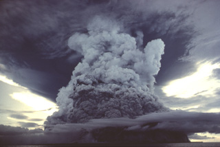 A powerful eruption column rising above Colo volcano is seen from the south on August 22, 1983. Pyroclastic flows from this explosion continued 500 m beyond the SSW coast of the island and 1 km beyond the NNW coast. This photo was taken about one month after the paroxysmal eruption on July 23, which produced pyroclastic flows that swept over virtually the entire island.
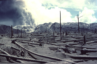 An eruption plume rises from the summit crater of Colo volcano on August 19, 1983 above a grove of coconut trees uprooted by pyroclastic flows on the SE side of Una-Una Island. The devastating pyroclastic-flow deposits of the July 23 eruption were 5 m thick on the SW side of the island.
 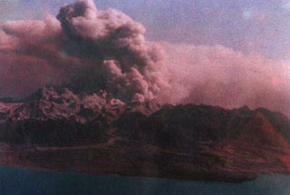 A broad ash plume rises above Colo volcano on the island of Una-Una during the powerful 1983 eruption. Phreatic eruptions began on July 18. All inhabitants of the island were evacuated prior to the paroxysmal eruption at 1623 hrs on July 23, when pyroclastic flows devastated most of the island. Intermittent large explosive eruptions, some producing pyroclastic flows, continued until August 30, and minor ash eruptions lasted until October 10. White and sometimes gray "smoke" was reported November-December, presumably from phreatic eruptions.
Maps are not currently available due to technical issues.
The following 1 samples associated with this volcano can be found in the Smithsonian's NMNH Department of Mineral Sciences collections, and may be availble for research (contact the Rock and Ore Collections Manager). Catalog number links will open a window with more information.
| Catalog Number | Sample Description | Lava Source | Collection Date |
|---|---|---|---|
| NMNH 116691-32 | Artifact | -- | 1 Aug 1983 |
| Copernicus Browser | The Copernicus Browser replaced the Sentinel Hub Playground browser in 2023, to provide access to Earth observation archives from the Copernicus Data Space Ecosystem, the main distribution platform for data from the EU Copernicus missions. |
| MIROVA | Middle InfraRed Observation of Volcanic Activity (MIROVA) is a near real time volcanic hot-spot detection system based on the analysis of MODIS (Moderate Resolution Imaging Spectroradiometer) data. In particular, MIROVA uses the Middle InfraRed Radiation (MIR), measured over target volcanoes, in order to detect, locate and measure the heat radiation sourced from volcanic activity. |
| MODVOLC Thermal Alerts | Using infrared satellite Moderate Resolution Imaging Spectroradiometer (MODIS) data, scientists at the Hawai'i Institute of Geophysics and Planetology, University of Hawai'i, developed an automated system called MODVOLC to map thermal hot-spots in near real time. For each MODIS image, the algorithm automatically scans each 1 km pixel within it to check for high-temperature hot-spots. When one is found the date, time, location, and intensity are recorded. MODIS looks at every square km of the Earth every 48 hours, once during the day and once during the night, and the presence of two MODIS sensors in space allows at least four hot-spot observations every two days. Each day updated global maps are compiled to display the locations of all hot spots detected in the previous 24 hours. There is a drop-down list with volcano names which allow users to 'zoom-in' and examine the distribution of hot-spots at a variety of spatial scales. |
|
WOVOdat
Single Volcano View Temporal Evolution of Unrest Side by Side Volcanoes |
WOVOdat is a database of volcanic unrest; instrumentally and visually recorded changes in seismicity, ground deformation, gas emission, and other parameters from their normal baselines. It is sponsored by the World Organization of Volcano Observatories (WOVO) and presently hosted at the Earth Observatory of Singapore.
GVMID Data on Volcano Monitoring Infrastructure The Global Volcano Monitoring Infrastructure Database GVMID, is aimed at documenting and improving capabilities of volcano monitoring from the ground and space. GVMID should provide a snapshot and baseline view of the techniques and instrumentation that are in place at various volcanoes, which can be use by volcano observatories as reference to setup new monitoring system or improving networks at a specific volcano. These data will allow identification of what monitoring gaps exist, which can be then targeted by remote sensing infrastructure and future instrument deployments. |
| Volcanic Hazard Maps | The IAVCEI Commission on Volcanic Hazards and Risk has a Volcanic Hazard Maps database designed to serve as a resource for hazard mappers (or other interested parties) to explore how common issues in hazard map development have been addressed at different volcanoes, in different countries, for different hazards, and for different intended audiences. In addition to the comprehensive, searchable Volcanic Hazard Maps Database, this website contains information about diversity of volcanic hazard maps, illustrated using examples from the database. This site is for educational purposes related to volcanic hazard maps. Hazard maps found on this website should not be used for emergency purposes. For the most recent, official hazard map for a particular volcano, please seek out the proper institutional authorities on the matter. |
| IRIS seismic stations/networks | Incorporated Research Institutions for Seismology (IRIS) Data Services map showing the location of seismic stations from all available networks (permanent or temporary) within a radius of 0.18° (about 20 km at mid-latitudes) from the given location of Colo. Users can customize a variety of filters and options in the left panel. Note that if there are no stations are known the map will default to show the entire world with a "No data matched request" error notice. |
| UNAVCO GPS/GNSS stations | Geodetic Data Services map from UNAVCO showing the location of GPS/GNSS stations from all available networks (permanent or temporary) within a radius of 20 km from the given location of Colo. Users can customize the data search based on station or network names, location, and time window. Requires Adobe Flash Player. |
| DECADE Data | The DECADE portal, still in the developmental stage, serves as an example of the proposed interoperability between The Smithsonian Institution's Global Volcanism Program, the Mapping Gas Emissions (MaGa) Database, and the EarthChem Geochemical Portal. The Deep Earth Carbon Degassing (DECADE) initiative seeks to use new and established technologies to determine accurate global fluxes of volcanic CO2 to the atmosphere, but installing CO2 monitoring networks on 20 of the world's 150 most actively degassing volcanoes. The group uses related laboratory-based studies (direct gas sampling and analysis, melt inclusions) to provide new data for direct degassing of deep earth carbon to the atmosphere. |
| Large Eruptions of Colo | Information about large Quaternary eruptions (VEI >= 4) is cataloged in the Large Magnitude Explosive Volcanic Eruptions (LaMEVE) database of the Volcano Global Risk Identification and Analysis Project (VOGRIPA). |
| EarthChem | EarthChem develops and maintains databases, software, and services that support the preservation, discovery, access and analysis of geochemical data, and facilitate their integration with the broad array of other available earth science parameters. EarthChem is operated by a joint team of disciplinary scientists, data scientists, data managers and information technology developers who are part of the NSF-funded data facility Integrated Earth Data Applications (IEDA). IEDA is a collaborative effort of EarthChem and the Marine Geoscience Data System (MGDS). |