NOTICE: Due to system maintenance, this website may be intermittently unavailable between 0800 and 2200 EDT (UTC -4 hours) on 14 September. Sorry for the inconvenience.


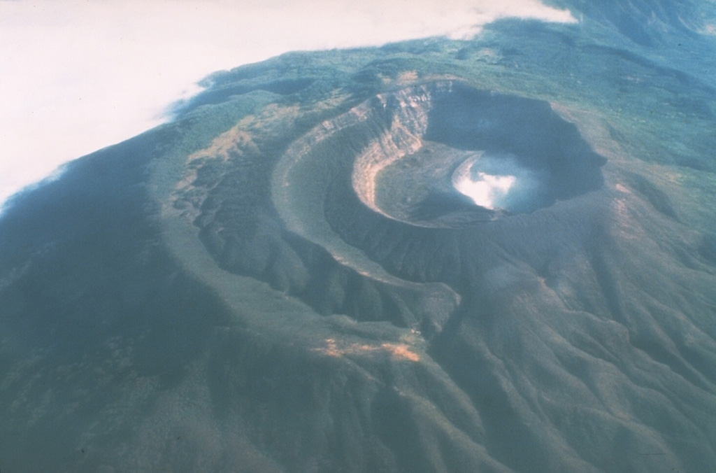
During 24-31 March, activity at Santa Ana decreased to low levels in comparison to the previous 4 months of moderate activity. During the report period, seismicity was at relatively low levels, steam plumes occasionally rose ~200 m above the volcano (or 8,400 ft a.s.l.), and the daily sulfur-dioxide flux was between 500 and 1,000 metric tons. The Alert Level remained at red, the highest level, within 5 km of the volcano's summit crater.
Source: Servicio Nacional de Estudios Territoriales (SNET)
Two days visiting the crater lake and fumaroles during mid-2007
Researchers from Michigan Technological University (MTU) and Servicio Nacional de Estudios Territoriales (SNET) visited the crater of Santa Ana on 28 June and 5 July 2007 to measure crater lake and fumarole temperatures, and to carry out routine water sampling.
Crater lake. The crater lake appeared yellowish-green and had a maximum temperature of 57.5°C, measured by a thermocouple at the northern shore. The crater lake was observed to have shifted westward in position since the 1 October 2005 eruption, drowning the main pre-eruption fumarole field to the W and receding from its eastern border (figure 13). A subaqueous hot spring was observed in the center of the lake at the end of a peninsula of exposed sediments (figure 14). The hot spring exhibited episodic pulses of bubbling water about every 5 minutes.
 |
Figure 13. The yellowish-green acid crater lake of Santa Ana volcano as seen when viewed on 28 June 2007 looking towards the N. Photo taken by Anna Colvin. |
Fumaroles. Crater fumaroles were observed to the W and S of the crater lake, and weak fumaroles were also observed on the upper wall above the flat area and below the SW crater rim. The southern crater fumaroles and the upper fumaroles were measured by thermocouple and radiometer (Extech 42545) (figure 15). Fumaroles to the W were not measured due to limited accessibility.
 |
Figure 15. At Santa Ana, the location of fumarole measurements and the hot spring shown in the previous figure. View is towards the SW. Photo mosaic taken 5 July 2007 by Matt Patrick. |
The seven largest southern crater fumaroles were measured along an E-W transect. The lower fumaroles emitted mainly water vapor, though some sulfur crystals and a weak sulfurous smell were present. Lower fumaroles temperatures ranged from 92.0 to 95.2°C, and thermocouple and radiometer measurements agreed very well (to within 3%). The upper fumaroles were diffuse and relatively weak, occurring in loosely consolidated tephra. The upper fumaroles emitted mainly water vapor and lacked sulfur deposits or sulfurous smell. Upper fumaroles temperatures ranged from 70.0 to 79.0°C, and thermocouple and radiometer measurements agreed well (to within 6%).
Information Contacts: Demetrio Escobar and Francisco Montalvo, Servicio Nacional de Estudios Territoriales, SNET, Km. 5 1/2 carretera a Santa Tecla y Calle las Mercedes, contiguo a Parque de Pelota, Edificio SNET, Apartado Postal ##27, Centro de Gobierno, El Salvador 2283-2246 (URL: http://www.snet.gob.sv/); Matthew Patrick and Anna Colvin, Dept. of Geological and Mining Engineering and Sciences, Michigan Technological University, 1400 Townsend Drive, Houghton, MI 49931, USA.
2006: January
| February
| March
2005: August
| September
| October
| November
| December
2001: January
During 24-31 March, activity at Santa Ana decreased to low levels in comparison to the previous 4 months of moderate activity. During the report period, seismicity was at relatively low levels, steam plumes occasionally rose ~200 m above the volcano (or 8,400 ft a.s.l.), and the daily sulfur-dioxide flux was between 500 and 1,000 metric tons. The Alert Level remained at red, the highest level, within 5 km of the volcano's summit crater.
Source: Servicio Nacional de Estudios Territoriales (SNET)
During 24 February to 6 March, seismicity at Santa Ana was relatively stable, and the sulfur-dioxide flux was lower than during previous weeks. The level of water in the lagoon within the crater decreased significantly. The Alert Level at Santa Ana remained at Red, the highest level, within a 5-km radius around the volcano's summit crater.
Source: Servicio Nacional de Estudios Territoriales (SNET)
During 17-24 February, volcanic activity was at moderate levels at Santa Ana. Seismicity was relatively stable, and steam plumes rose to low levels above the volcano. The sulfur-dioxide flux was similar to measurements from previous weeks. The level of water in the lagoon within the crater decreased significantly. The Alert Level at Santa Ana remained at Red, the highest level, within a 5-km radius around the volcano's summit crater.
Source: Servicio Nacional de Estudios Territoriales (SNET)
During 3-10 February, volcanic activity was at moderate levels at Santa Ana. Seismicity was relatively stable, and steam plumes rose to low levels above the volcano. The sulfur-dioxide flux averaged 1,200 metric tons per day. The Alert Level at Santa Ana remained at Red, the highest level, within a 5-km radius around the volcano's summit crater.
Source: Servicio Nacional de Estudios Territoriales (SNET)
During 27 January- 3 February, volcanic activity was at moderate levels at Santa Ana. On the 2nd, there was an increase in seismicity at the volcano, possibly related to an earthquake on the coast of Guatemala. There was also an increase in the sulfur-dioxide flux, with an average of 2,000 metric tons measured daily. Steam plumes rose to low levels above the volcano. The Alert Level at Santa Ana remained at Red, the highest level, within a 5-km radius around the volcano's summit crater.
Source: Servicio Nacional de Estudios Territoriales (SNET)
Seismicity at Santa Ana during 14-20 January 2006 was at normal levels. Degassing continued, with sporadic gas-and-steam emissions that rose about 200 m before dispersing. Sulfur dioxide flux, measured 6 km SW of the volcano, ranged from 163 to 1,578 metric tons/day. The hazard status remained at Alert Red, the highest level, within a 5-km radius of the central crater.
Source: Servicio Nacional de Estudios Territoriales (SNET)
During 6-13 January, volcanic activity was moderate at Santa Ana. Seismicity was a bit over normal levels with small earthquakes occurring, which were interpreted as being associated with gas pulses. Continuous low-level emissions of steam and gas originated from the lagoon and from fumaroles within the crater. The sulfur-dioxide flux ranged between 544 and 2,300 metric tons per day. The Alert Level remained at Red, the highest level, within a 5-km radius around the volcano's summit crater.
Source: Servicio Nacional de Estudios Territoriales (SNET)
During 30 December to 6 January, volcanic activity was moderate at Santa Ana. Seismicity was a bit over normal levels with small earthquakes occurring, which were interpreted as being associated with gas pulses. Continuous low-level emissions of steam and gas originated from the lagoon and from fumaroles within the crater. Gas rose 200-500 m above the crater (or 8,400-9,400 ft a.s.l.) and drifted SW. The sulfur-dioxide flux ranged between 180 and 1,476 metric tons per day. The Alert Level remained at Red, the highest level, within a 5-km radius around the volcano's summit crater.
Source: Servicio Nacional de Estudios Territoriales (SNET)
Observations of Santa Ana's crater on 28 December revealed that there were continuous emissions of steam and gas from the lagoon and fumaroles located within the crater. Gas rose 200-500 m above the crater (or 8,400-9,400) and drifted SW. On 30 December, seismicity at Santa Ana was above background levels. Small earthquakes occurred, which were interpreted as being associated with gas pulses. Gas emissions rose to low levels. The Alert Level remained at Red, the highest level, within a 5-km radius around the volcano's summit crater.
Source: Servicio Nacional de Estudios Territoriales (SNET)
During 21-23 December, seismicity at Santa Ana was above background levels. Small earthquakes occurred, which were interpreted as being associated with gas pulses. Gas emissions rose to low levels. The Alert Level remained at Red, the highest level, within a 5-km radius around the volcano's summit crater.
Source: Servicio Nacional de Estudios Territoriales (SNET)
During 14-20 December, seismicity at Santa Ana was above background levels. Small earthquakes occurred, which were interpreted as being associated with gas pulses. Gas emissions rose to low levels. The Alert Level remained at Red, the highest level, within a 5-km radius around the volcano's central crater.
Source: Servicio Nacional de Estudios Territoriales (SNET)
Seismic activity began to increase at Santa Ana on 26 November. At that time, hundreds of metric tons of sulfur dioxide were emitted from the volcano each day, which was not as high as levels measured prior to the 1 October eruption. Gas emissions rose to ~300 m above the volcano and only slight changes were noted in the color of the lagoon in the interior of the crater. SNET stated that the high level of activity indicated that an eruption could occur in the following days. During 7-12 December, activity was still at high levels. The Alert Level remained at Red, the highest level, within a 5-km-radius around the volcano's central crater.
Source: Servicio Nacional de Estudios Territoriales (SNET)
During 23-28 November, seismicity at Santa Ana was above background levels. Small earthquakes occurred that were interpreted as being associated with gas pulses. The amount of gas emitted was low. The Alert Level remained at Red, the highest level, within a 5-km radius around the volcano's central crater.
Source: Servicio Nacional de Estudios Territoriales (SNET)
During 16-21 November seismicity at Santa Ana was above background levels; a minor increase on 17 November was probably due to strong wind disturbing the seismic equipment. Small earthquakes occurred that were interpreted as being associated with the fracturing of rocks and gas pulses. The amount of gas emitted was low. The daily sulfur-dioxide flux averaged about 1,000 metric tons during 11-17 November. The Alert Level within a 5-km radius around the volcano's central crater remained at Red, the highest level.
Source: Servicio Nacional de Estudios Territoriales (SNET)
During 9-14 November, seismicity at Santa Ana was above background levels and slightly increased on 13 November. Small earthquakes occurred that were interpreted as being associated with the fracturing of rocks and gas pulses. The amount of gas emitted was low. The sulfur-dioxide flux ranged between 100 and 1,200 metric tons daily. The Alert Level within a 5-km radius around the volcano's central crater remained at Red, the highest level.
Source: Servicio Nacional de Estudios Territoriales (SNET)
During 2-7 November, seismicity and volcanic activity remained at relatively low levels at Santa Ana. Small earthquakes occurred that were associated with the fracturing of rocks and gas pulses. Sulfur-dioxide emissions were low, with 100 to 200 metric tons recorded daily. Gas emissions rose to low levels above the volcano. The Alert Level within a 5-km radius around the volcano's central crater remained at Red, the highest level.
Source: Servicio Nacional de Estudios Territoriales (SNET)
During 30-31 October, seismicity increased at Santa Ana. Volcanic activity appeared to slightly increase starting on 28 October. Sulfur-dioxide emission rates during 28 and 29 October averaged 257 metric tons per day. The Alert Level within a 5-km radius around the volcano's central crater was at Red, the highest level.
Source: Servicio Nacional de Estudios Territoriales (SNET)
During 19-23 October, seismicity was relatively stable and there were low-level gas emissions at Santa Ana. On 22 October, a lahar was reactivated in the Potrero Arriba area, NE of the volcano. During 22-25 October, there was an increase in the amount of tremor at the volcano. In addition, seismicity associated with gas emissions slightly increased. The Alert Level within a 5-km radius around the volcano's central crater was at Red, the highest level.
Source: Servicio Nacional de Estudios Territoriales (SNET)
During 12-17 October, seismicity was relatively stable and there were low-level gas emissions at Santa Ana. Storms on 12 October caused the generation of lahars that traveled towards Coatepeque.
Source: Servicio Nacional de Estudios Territoriales (SNET)
During 5-11 October, small explosions, degassing, and low-to-moderate seismicity occurred at Santa Ana. Inclement weather during much of the report period prohibited ground and satellite observations and sulfur-dioxide measurements. During an aerial inspection of the volcano on 11 October, no changes were observed at the crater. Around the 11th, sulfur-dioxide measurements were at 600-700 metric tons per day. SNET noted that eruptive activity could continue at the volcano and an eruption similar to, or smaller than, the October 1 eruption could occur in the future. The Alert Level within a 5-km radius around the volcano's central crater was at Red, the highest level.
Source: Servicio Nacional de Estudios Territoriales (SNET)
SNET reported that a sudden eruption at Santa Ana (also called Ilamatepec) on 1 October around 0820 produced an ash-and-gas plume to a height of ~10 km above the volcano (or 40,600 ft a.s.l.). According to the Washington VAAC, ash was visible on satellite imagery at a height of ~14 km (46,000 ft) a.s.l. Ash fell in towns W of the volcano, including in Naranjos, Nahuizalco, Juayúa, Ahuachapán, and La Hachadura. Volcanic blocks up to a meter in diameter fell as far as 2 km S of the volcano's crater. Lahar deposits were seen SE of the volcano. The Alert Level within a 4-km radius around the volcano's central crater was raised to Red, the highest level. According to news reports, two people were killed by landslides (possibly caused by heavy rain in the area) in the town of Palo Campana, and thousands of residents near the volcano were evacuated. As many as 1,400 hectares of crops were damaged by ash.
Prior to the eruption, significant changes in seismicity were not noted. On 3 October, after the eruption, seismicity fluctuated and small explosions occasionally occurred. Earthquakes associated with explosions were recorded. In addition, there was a decrease in the amount of sulfur dioxide emitted from the volcano. SNET noted that eruptive activity could continue at the volcano.
Sources: Reuters; Associated Press; Servicio Nacional de Estudios Territoriales (SNET); ReliefWeb
During 21-26 September, seismicity and gas emissions were above normal levels at Santa Ana as they had been since 27 July. Microseismicity remained at relatively high levels. During the report period, gas plumes rose to a maximum height of ~1 km above the volcano (or 11,000 ft a.s.l.) on 26 September. During a visit to the crater on 21 September, observers noted that the summit crater lagoon had become greener and small rock slides occurred in a fumarolic area. Santa Ana remained at Alert Level Yellow Phase 1.
Source: Servicio Nacional de Estudios Territoriales (SNET)
During 15-19 September, seismicity and gas emissions were above normal levels at Santa Ana as they had been since 27 July. Microseismicity remained at relatively high levels. During the report period, gas plumes rose to ~500 m above the volcano (or 9,400 ft a.s.l.) and the sulfur-dioxide flux reached a maximum of 3,320 metric tons per day on 16 September. No significant changes were seen at the volcano's crater when observed on 19 September in comparison to 13 September. Intense degassing continued and the lagoon remained a "dark coffee" color. Incandescence was visible inside some cracks. Santa Ana remained at Alert Level Yellow Phase 1.
Source: Servicio Nacional de Estudios Territoriales (SNET)
During 7-12 September, seismicity and gas emissions were above normal levels at Santa Ana as they had been since 27 July. Microseismicity increased significantly on 12 September. During a visit to the volcano on 8 September, larger areas of incandescence were visible at a field of fumaroles than during a visit on 29 August. During the report period, gas plumes rose to ~500 m above the volcano (or 9,400 ft a.s.l.) and the sulfur-dioxide flux was over 1,000 metric tons per day. Satellite imagery showed a thermal anomaly at the volcano on several days. Santa Ana remained at Alert Level Yellow Phase 1.
Source: Servicio Nacional de Estudios Territoriales (SNET)
During 1-6 September, seismicity and gas emissions were above normal levels at Santa Ana as they had been since 27 July. Tremor continued to be recorded, and on 2 August a cluster of at least eight small earthquakes occurred. The earthquakes were not felt by local residents. During the report period, gas plumes rose to ~500 m above the volcano (or 9,400 ft a.s.l.) and the sulfur-dioxide flux was over 1,000 metric tons per day. Satellite imagery from 5 September showed a thermal anomaly at the volcano. Santa Ana remained at Alert Level Yellow Phase 1.
Source: Servicio Nacional de Estudios Territoriales (SNET)
SNET reported a significant increase in seismic activity at Santa Ana (also called Ilamatepec) on the night of 27 August. A cluster of 17 volcano-tectonic earthquakes were recorded, with four located S of the volcano. Afterwards, continuous high-frequency tremor was recorded until at least 30 August. Observations made on 29 August revealed incandescent rocks in the fumarole field. The incandescence was due to the hot gases emitted from the fumaroles heating the rocks. A significant increase in sulfur-dioxide emission was recorded, and gas-and-steam plumes rose 500-1,000 m above the volcano's crater (or 9,400-11,000 ft a.s.l.). As a safety measure, access to the volcano's crater was restricted to visitors.
Prior to the current increase in activity, strong degassing had been measured at the volcano since June 2004. An ash emission occurred on 16 June 2005, and a slight increase in seismicity and a significant increase in gas emission was measured from 27 July until at least 30 August.
Source: Servicio Nacional de Estudios Territoriales (SNET)
Beginning on 12 January several news reports stated that increased volcanic activity occurred at Santa Ana volcano. The Washington VAAC reported that an eruption occurred at 1800 on 16 January that sent ash to ~3.7 km a.s.l. Local observations by volcanologists revealed that an eruption did not occur and no new lava or magma was in the summit crater. Glowing cracks that were visible at night were determined to be an existing fumarole field with measured temperatures of 550 °C. Scientists believe that a magnitude 7.7 earthquake that occurred off the coast of Central America at 1133 on 13 January, killing several hundred people, did not cause an increase in activity at the volcano. Since 12 January there have been reports of increased gas emissions and the volcano is being closely monitored for any changes in activity.
Sources: Washington Volcanic Ash Advisory Center (VAAC); La Prensa Grafica; Diario del Hoy (elsalvador.com); US Geological Survey Volcano Disaster Assistance Program (VDAP); US Geological Survey Earthquake Hazards Program
Reports are organized chronologically and indexed below by Month/Year (Publication Volume:Number), and include a one-line summary. Click on the index link or scroll down to read the reports.
Plume from inner crater fumaroles
Observations were made during a flight over the country. A moderate plume rose from a bank of fumaroles on the SE wall of the inner crater, very similar to its appearance in November 1978.
Information Contacts: R. Stoiber, S. Williams, R. Naslund, L. Malinconico, and M. Conrad, Dartmouth College.
Scientists visit the summit crater and sample the acid lake
The acid lake within the summit crater of Santa Ana was extensively sampled by a scientific team using a small boat on 28-29 January 2000. The ambient lake temperature was ~18.9°C with 1.01 pH. A fumarole field on the crater wall adjacent to the lake had a maximum temperature of 523°C. A hot spring vent near the fumarole field feeds warm water (80°C) into the lake. This new lake sampling allows comparisons with data taken in 1992-93.
Santa Ana, El Salvador's highest volcano, is a large stratovolcano immediately W of Coatepeque Caldera. The broad volcano summit is cut by several crescent craters. A series of parasitic vents and cones have formed along a fissure system that extends from near the town of Chalchuapa N of the volcano to the San Marcelino cinder cone on the SE flank.
Information Contacts: Demetrio Escobar and Marisa Orantes, Centro de Investigaciones Geotecnicas, Calle Antigua La Chacra, Costado Oriente de Talleres "El Coro", PP 109 San Salvador, El Salvador; Alain Bernard, BRUGEL, Université Libre de Bruxelles 160/02 50, Ave. Roosevelt, 1050 Brussels, Belgium; Bill Rose, Colleen Riley, and Keith MacPhail, Department of Geological Engineering and Sciences, Michigan Technological University, Houghton, MI 49931, USA; Uwe Grunewald, Insitut fuer Geowissenschaften, Burgweg 11, 07749 Jena, Germany.
2000-2001 observations of glowing fumaroles and release of magmatic gas
Santa Ana's summit crater contains an acid lake that in 2000 was ~200 m in diameter with a maximum depth of 27 m; its volume was estimated at ~200,000 m3. The lake water has a composition typical of acid-sulfate-chloride lakes (table 1). Dissolved sulfates yielded delta34S of 16.0, suggesting that a significant sulfur source is magmatic SO2 gas. Several hot springs with 80°C temperatures lie along the shore of the lake and have compositions close to that of the lake waters. Fumaroles on the W side of the lake had a maximum temperature, recorded in January 2000, of 523°C.
Table 1. Compositions of Santa Ana's crater lake waters for 2000-2001. Samples were collected in 2000 during January (sample designation, SAL), July (SAN1), and August (SAN2), and collected in 2001 during February (SAP). Chemical concentrations are in mg/L. Courtesy of the authors.
| Component | January 2000 | July 2000 | August 2000 | February 2001 |
| Water pH | 0.91 | 0.91 | 0.9 | 0.85 |
| T, °C | 18.9 | 30 | 30 | 26 |
| Al | 1155 | 1214 | 1161 | 1617 |
| Ca | 819 | 862 | 805 | 1126 |
| Fe | 761 | 832 | 720 | 1020 |
| K | 137 | 145 | 139 | 203 |
| Mg | 299 | 307 | 283 | 379 |
| Mn | 16 | 17 | 16 | 19 |
| Na | 377 | 395 | 367 | 496 |
| Si | 115 | 132 | 129 | 168 |
| F | 218 | 194 | 194 | 383 |
| Cl | 5555 | 7603 | 7267 | 8564 |
| SO4 | 8647 | 10907 | 10661 | 12682 |
| TDS | 18118 | 22639 | 21773 | 26657 |
| SO4/Cl ratio | 1.56 | 1.43 | 1.47 | 1.48 |
| δ34S | 16 | 16.1 | 16 | 16 |
The Centro de Investigaciones Geotecnicas (CIG) noted that during May-September 2000 the lake temperature increased from 19 to 30°C. On 15 February 2001, the temperature was 26°C and the pH was 0.8-0.9. Bubbling and increased gas emissions were observed in several areas of the lake. During February 2001, sulfur spherules in the lake caused the water color to change to a shade of milky yellow-brown. During May-September 2000, the composition of the lake was only slightly affected, suggesting that no major changes occurred within the hydrothermal system beneath the lake (table 1).
Beginning in August 2000, observers found the increasingly deleterious effects of acidic vapor and rainfall on vegetation in the area SW and N of the crater. Winds are dominated by NE trades, which generally drive the plume from the volcano over the rim of the crater to the S and W. By December 2000, more severe effects on the flora were reported, and an area of ~8-10 km2 located S and W of the crater contained markedly discolored and defoliated vegetation. Brief periods of acidic rainfall were reported at Juayua, 13 km W of the crater. In January 2001, incandescent areas within the fumarolic region W of the crater lake were observed at night and may have been present earlier.
COSPEC measurements of the plume were made using the Guatemalan COSPEC on 8 and 9 February 2001. Tripod-based surveys were made from Cerro Verde (elevation ~2,000 m), 2 km S of the crater. Automobile-based traverses conducted along the Santa Ana - Sonsonate highway (5 km W of Santa Ana) were made on 9 February. These surveys resulted in an average SO2 flux of 393 tons/day on 8 February and 244 tons/day on 9 February. During measurements of the plume from the Cerro Verde site, periods of noticeable puffing were observed, affecting the COSPEC measurements by a factor greater than 8.
Two new, permanent telemetered seismic stations, located 1.5 km SE of the crater and 5.5 km NW on Cerro Retiro, were installed by USGS/VDAP and CIG personnel in February 2001. During February, these stations did not detect abnormal seismicity beneath the volcano. A portable recorder located at Finca San Blas from about 20 January through 9 February registered little volcano-seismic activity apart from a few small fumarolic emissions in late January.
Interpretation: The changes since the summer of 2000 are apparently due to increased venting of a well-developed hydrothermal system through the lake, hot springs, and fumaroles. This hydrothermal system is venting substantially higher SO2 (and presumably other gases) in an acidic plume blown by NE trade winds. The lack of seismic activity suggests that the hydrothermal activity increase was not driven by the arrival of new magma beneath the crater.
The SO2 emission rate was high for a quiescent volcano that lacks an open vent. The SO2 may evolve from a gas reservoir below the hydrothermal system, trapped by a hydrothermal cap (clay or silica) as a result of long term (centuries or millennia) crystallization of magma below the cap (Giggenbach and others, 1990). The recent increase in degassing may reflect fracturing or leaking of the hydrothermal cap.
Crater hazards. Reports suggest that significant phreatic activity could occur at Santa Ana, including ejected bombs and blocks, even without magmatic movement under the volcano. This eventuality, a potential extension of the pulsating SO2 emissions, could make conditions unsafe in the crater region. Furthermore, unsubstantiated rumors from local residents and ambiguous geological observations (e.g., abundant dust-possibly settled ash-coating the upper surfaces of leaves of plants in the crater and on the upper slopes) have suggested to some that minor, rare phreatic eruptive events have already occurred.
January 2001 earthquake. At about 1135 on 13 January 2001, an earthquake with a magnitude of 7.6 and a depth of 60 km occurred off the El Salvadoran coastline, its epicenter (at 12.8° N latitude and 88.8°W longitude) lay ~150 km SE of Santa Ana volcano. The earthquake caused extensive damage and destruction throughout much of El Salvador. By 19 January the country was struck by over 660 aftershocks. According to information provided by the National Emergency Committee (COEN) on 17 January 2001, the death toll was put at 681, with 2,615 injured. Approximately 20,000 people moved into over 80 temporary shelters; 90,929 houses sustained damaged, with 24,759 destroyed; and 45,842 people had been evacuated.
News sources based on reports from local residents raised concern that the earthquake was the result of eruptions from Santa Ana volcano. This conclusion was almost certainly in error.
However, during a helicopter overflight on 17 January, James Vallance, an American volcanologist, believed he saw incandescence in the crater. During a subsequent overflight on 18 January, Vallance, Carlos Pullinger, and Demetrio Escobar observed that the incandescence came from glowing cracks in the fumarole field, which, as noted above, had measured temperatures exceeding 500°C. They noted that there was no new lava or magma visible in the crater to indicate recent eruptions. This conclusion was substantiated later by measurements with a portable seismograph, which failed to detect local earthquakes under the volcano.
References. Pullinger, C., 1998, Evolution of the Santa Ana Volcanic complex, El Salvador: Unpublished MS thesis, Michigan Technological University, 152 p.
Larde, J., 1923, El Volcan de Izalco, San Salvador.
Gutierrez, R.E., and Escobar, C.D., 1994, Crisis en la actividad del Volcan de Santa Ana (Ilamatepec), del 22 de Julio al 21 de Agosto 1992: San Salvador, Publicacion Especial, Centro de Investiagiones Geotecnicas, 13 p.
Giggenbach, W.F., Garcia, N., Londono, C., Rodriguez, L., Rojas, N., and Calvache, M., 1990, The chemistry of fumarolic vapor and thermal-spring discharges from the Nevado del Ruiz volcanic-magmatic-hydrothermal system, Colombia: J. Volcanol. Geoth. Res. 42, p. 13-40.
Information Contacts: Demetrio Escobar and Marisa Orantes, Centro de Investigaciones Geotecnicas (CIG), Calle Antigua La Chacra, Costado Oriente de Talleres "El Coro," PP 109 San Salvador, El Salvador; Alain Bernard, Université Libre de Bruxelles 160/02 50, Ave. Roosevelt, 1050 Brussels, Belgium; William L. Rose, Department of Geological Engineering and Sciences, Michigan Technological University, Houghton, MI 49931, USA; Otoniel Matias and Gustavo Chigna, INSIVUMEH, 7a Av. 14-57, Zona 13, Guatemala City, Guatemala; James Vallance, Department of Civil Engineering and Applied Mechanics, McGill University, Montreal, Quebec H3A 2K6, Canada.
Sudden eruption on 1 October 2005; thousands evacuated
This report discusses a 1 October 2005 eruption at Santa Ana (also called Ilamatepec) that sent a plume to 14 km altitude and led to initial estimates cited in the press of two deaths (perhaps from landslides), several injuries, and the evacuation of over 2,000 people. Observations of glowing fumaroles and release of magmatic gas during 2000-2001 were previously reported at Santa Ana (BGVN 26:04). Servicio Nacional de Estudios Territoriales (SNET) scientists noticed that between the summer of 2000 and April 2001 there was increased venting of a well-developed hydrothermal system through the crater lake, hot springs, and fumaroles, but these changes were not accompanied by detected seismicity, which was then taken to suggest that the increase in hydrothermal activity was not driven by the arrival of new magma beneath the crater. An ASTER (Advanced Spaceborne Thermal Emission and Reflection Radiometer) image from 3 February 2001 shows the volcano's setting well before the eruption (figure 1).
SNET reported that a sudden eruption at Santa Ana took place around 0820 on 1 October 2005. They estimated that it produced an ash-and-gas plume to a height of ~ 10 km above the volcano. According to the Washington VAAC, ash was visible on satellite imagery at an altitude of ~ 14 km. The US Air Force Weather agency provided images of the plume (figure 2).
Ash fell in towns W of the volcano, including in Naranjos, Nahuizalco, Juayúa, Ahuachapán (NW), and La Hachadura (at the border, ~ 40 km W, figure 3). SNET produced a graphic similar to an isopach map that showed near-source thicknesses provisionally to over 10 cm. The 10 cm isopach stretched ~ 5 km W; the 1 mm isopach, ~ 20 km W. The outermost isopach, presumably where measurable ash fell, was not closed; instead it was cut off along the Guatemalan border (~ 40 km to W of Santa Ana) and the caption said that ash would fall into valleys in Guatemala and to the sea. Volcanic blocks up to a meter in diameter fell as far as 2 km S of the volcano's crater. Lahar deposits were seen SE of the volcano. The alert level within a 4-km radius around the volcano's central crater was raised to Red, the highest level.
According to news reports, two people were killed by landslides (possibly caused by heavy rain in the area) in the town of Palo Campana, and thousands of residents near the volcano were evacuated. As many as 1,400 hectares of crops were damaged by ash (1 hectare = 10,000 m2). News also mentioned other processes such as a flood of boiling mud and water, and molten rocks, some the size of small automobiles, that will be discussed in later reports. A several-minute-long video from the LPG Television website appears as both a hyperlink and an active file on our website. In addition to numerous interviews with evacuees, it shows a host of features including what appear to be the swaths left by previously inflated mudflows passed down steep-sided valleys.
Prior to the eruption, no significant change in seismicity was observed. On 3 October, after the eruption, seismicity fluctuated and small explosions occasionally occurred. Earthquakes associated with explosions were recorded. In addition, there was a decrease in the amount of SO2 emitted from the volcano.
Strong degassing had been measured at the volcano since June 2004. An ash emission occurred on 16 June 2005, and a slight increase in seismicity and a significant increase in gas emission were measured from 27 July until at least 30 August. SNET also reported a significant increase in seismic activity at Santa Ana on the night of 27 August. A cluster of 17 volcano-tectonic earthquakes were recorded, with four located S of the volcano. Afterwards, continuous high-frequency tremor was recorded until at least 30 August. Observations made on 29 August revealed incandescent rocks in the fumarole field, effects attributed to hot gases heating the rocks to sufficient temperature to glow. A significant increase in SO2 emission was recorded, and gas-and-steam plumes rose 500-1,000 m above the volcano's crater. As a safety measure, access to the volcano's crater was restricted.
From 27 July until the eruption on 1 October, seismicity and gas emissions were above normal levels, and Santa Ana was at alert level yellow. During the first week of September, tremor continued to be recorded, and on 2 September a cluster of at least eight small earthquakes occurred, which were not felt by local residents. Gas plumes rose to ~ 500 m above the volcano, and the SO2 flux was over 1,000 metric tons per day during the first two weeks of September. Satellite imagery from 5 September showed a thermal anomaly.
Microseismicity increased significantly on 12 September. During a visit to the volcano on 8 September, larger areas of incandescence were visible at a field of fumaroles than during a visit on 29 August. Satellite imagery showed a thermal anomaly at the volcano on several days during the second week of September.
During 15-19 September gas plumes rose to ~ 500 m above the volcano, and the SO2 flux reached a maximum of 3,320 metric tons per day on 16 September. Microseismicity remained at relatively high levels. No significant changes were seen at the volcano's crater when observed on 19 September in comparison to 13 September. Intense degassing continued and the crater lake (lagoon) remained a dark coffee color. Incandescence was visible inside some cracks.
During a visit to the crater on 21 September, observers noted that the lagoon had become greener and small rock landslides occurred in the field of fumaroles. Gas plumes rose to ~ 1 km above the volcano on 26 September.
Following the eruption of 1 October, small explosions, degassing, and low-to-moderate seismicity occurred at Santa Ana during 5-11 October. Inclement weather prohibited ground and satellite observations, and sulfur-dioxide (SO2) measurements during much of the report period. During an aerial inspection of the volcano on 11 October, no changes were observed at the crater. Around 11 October, SO2 measurements were around 600-700 metric tons per day. The alert level within a 5-km radius around the volcano's central crater remained at Red.
Information Contacts: Servicio Nacional de Estudios Territoriales (SNET), Alameda Roosevelt y 55 Avenida Norte, Edificio Torre El Salvador, Quinta Planta, San Salvador, El Salvador (URL: http://www.snet.gob.sv); Washington Volcanic Ash Advisory Center (VAAC), NOAA/NESDIS Satellite Analysis Branch (SAB), 5200 Auth Road, Camp Springs, MD 20746, USA; Charles Holliday and Jenifer E. Piatt, U.S. Air Force Weather Agency (AFWA)/XOGM, Offutt Air Force Base, NE 68113, USA; NASA Earth Observatory (URL: http://earthobservatory.nasa.gov/NaturalHazards/); La Prensa Grafica and La Prensa Grafica Television, Final bulevar Santa Elena, frente a embajada de EUA, Antiguo Cuscatlán, La Libertad, San Salvador, El Salvador.
Post-eruption lahars but seismicity and SO2 fluxes both often low
Previous comments regarding terminal phases of the 1 October 2005 eruption (BGVN 30:09) included: . "Following the eruption of 1 October, small explosions, degassing, and low-to-moderate seismicity occurred at Santa Ana during 5-11 October . . .. During an aerial inspection of the volcano on 11 October, no changes were observed at the crater."
Carlos Pullinger (Servicio Nacional de Estudios Territoriales, SNET) later noted that "The 1 October eruption only lasted about 1 hour. After that we had some small activity, probably associated [with] degassing on Sunday evening [2 October] and at about the same time the continuous rains produced the first of a series of lahars that affected the communities close to the shore of Coatepeque lake. During the rest of the week it was very difficult to know what was going on because of continuous rains and cloudy conditions."
Pullinger further noted that some eye witnesses said that they had observed a column on 2 October. SNET registered strong and continuous tremor during approximately 1900-2400 (local time) on 2 October. Much of this activity coincided with rain-induced lahars. Over 300 mm of rain fell on the volcano that day. Using both witness reports and seismicity, SNET inferred that on 2 October the volcano possibly generated strong degassing or even geyser-type activity. However, there was no confirmation of ashfall deposits from these or other post-1 October events.The same type of seismicity continued intermittently until 5 October, but with much less intensity than on 2 October. SNET could not tell if there was any volcanic activity related to these events, or if it was mainly lahars. After the 5th continuous tremor was not recorded.
Post-eruption behavior. SNET reported that, in general, following Santa Ana's 1 October 2005 eruption, seismicity was relatively stable and there were generally low-level gas emissions (figure 4).
Storms on 12 October 2005 caused lahars that traveled E towards Lake Coatepeque (see ASTER image of the region in BGVN 30:09). On 22 October, a lahar was reactivated in the Potrero Arriba area, NE of the volcano. During 22-25 October, the volcano was subjected to increased tremor and a slight increase in seismicity associated with gas emissions. On 28 October volcanic activity appeared to increase slightly and sulfur-dioxide emission rates during 28 and 29 October averaged 257 metric tons per day. The Alert Level within a 5-km radius around the volcano's central crater was at Red, the highest level.
During the month of November 2005 seismicity, volcanic activity, and gas emissions all remained for the most part at relatively low levels. There were slight increases on 13, 17, and 26 November; but the 17 November increase was attributed to noise from strong winds. On 26 November only slight changes were noted in the color of the lagoon in the crater's interior, but gas emissions rose to ~ 300 m above the volcano. Small earthquakes occurred during November 2005, inferred to be associated with the fracturing of rocks and gas pulses. Sulfur-dioxide emissions were low during the first part of November, with 100 to 200 metric tons recorded daily, and during the latter part of November, with between 100 and ~ 1,500 metric tons recorded daily.
During December 2005, seismicity was above background levels. Observations of Santa Ana's crater on 28 December revealed that there were continuous emissions of steam and gas from the lagoon and fumaroles located within the crater (figure 5). Gas rose 200-500 m above the crater and drifted SW (figure 6). Small earthquakes occurred, but gas emissions rose to over ~ 2,500 tons per day (figure 4). The Alert Level remained at Red, the highest level, within a 5-km radius around the volcano's summit crater.
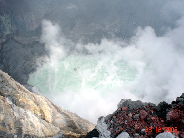 |
Figure 5. A photo taken from the crater rim at Santa Ana showing steam and gas emissions from both the lagoon and fumaroles located within the crater. Courtesy of SNET. |
 |
Figure 6. A photo of Santa Ana showing the 28 December 2005 gas emission that rose 200-500 m above the crater rim. Courtesy of SNET. |
From 30 December 2005 to early January 2006, seismic and steam emissions were moderate at Santa Ana. Seismicity was slightly above normal levels with small earthquakes occurring, which were interpreted as being associated with gas pulses. Low-level emissions of steam and gas from the lagoon and fumaroles within the crater remained the same as in December 2005. Gas rose 200-500 m above the crater and drifted SW. The sulfur-dioxide flux ranged between 180 and 1,476 metric tons per day. The Alert Level remained at Red, the highest level, within a 5-km radius around the volcano's summit crater.
Background. Santa Ana, El Salvador's highest volcano, is a massive, 2,381-m-high andesitic-to-basaltic stratovolcano that rises immediately W of Coatepeque caldera. Collapse of the volcano during the late Pleistocene produced a voluminous debris avalanche that swept into the Pacific Ocean, forming the Acajutla Peninsula. Reconstruction of the volcano subsequently filled most of the collapse scarp. The broad summit of the volcano is cut by several crescentic craters, and a series of parasitic vents and cones have formed along a 20-km-long fissure system that extends from near the town of Chalchuapa NNW of the volcano to the San Marcelino and Cerro la Olla cinder cones on the SE flank. Historical activity, largely consisting of small-to-moderate explosive eruptions from both summit and flank vents, has been documented since the 16th century. The San Marcelino cinder cone on the SE flank produced a lava flow in 1722 that traveled 13 km to the E.
Information Contacts: Servicio Nacional de Estudios Territoriales (SNET), Alameda Roosevelt y 55 Avenida Norte, Edificio Torre El Salvador, Quinta Planta, San Salvador, El Salvador (URL: http://www.snet.gob.sv/)
Lahars follow October 2005 eruptions; steam emissions
Our last report (BGVN 31:01) discussed post-eruption lahars following the sudden 1 October 2005 eruption (BGVN 30:09). This report contains two sections. The first section addresses regional processes such as vegetation loss, ash accumulation, and lahars on and beyond the E flank of Santa Ana (also known as Ilamatepec) to the shores of Lake Coatepeque. Those lahars began soon after the 1 October 2005 eruption. The information on these lahars chiefly came from a report (SNET, 2006) authored by El Salvador's Servicio Nacional de Estudios Territoriales (SNET).
The second section addresses monitoring and observations such as extensive steaming and drop in the surface elevation of the lake in the summit crater. Material for this section, primarily found on the SNET website, covers January-April 2006, when activity was fumarolic with no large eruptions. The 1 October 2005 eruption was possibly followed by a second one two days later on 3 October (SNET, 2006). A 3 October eruption was not mentioned in previous Bulletin reports.Carlos Pullinger explained that the evidence for the second eruption was tremor that day, but that could stemmed from other causes such as geysers in the summit crater lake, so the evidence for a 3 October eruption remains equivocal.
E-flank issues. October 2005 volcanism took place coincident with unusually high rains during tropical storm Stan (1-10 October 2005). On the E flank, the October 2005 eruptive episode killed extensive vegetation and left loose ash deposits covering the upper slopes (figure 7).
Based on a rain gauge 5 km W of the crater (national meteorological station Los Naranjos), rainfall in October averages 193 mm; the yearly average is 2,155 mm. In the months prior to October 2006, rainfall at that station remained at normal values, always below 460 mm per month. In contrast, rainfall reached 865 mm during October 2006. During the peak of the storm, 3-6 October 2005, the Los Naranjos rain gauge collected more than 100 mm per day; the highest reading of 320 mm was on 5 October.
The lahars on Santa Ana's E slope consisted of both material from the October 2005 eruption as well as previous deposits. The first lahar seen by local witnesses took place on the night of 2 October 2005. It carried material up to 2 m in diameter. The lahars that produced most of the damage were those that occurred immediately after the eruption and reached a maximum thickness of 1.5 m. Other lahars descended later in the storm, persisting well into 2006.The 2006 rainy season did not generate damaging lahars, just heavy runoff with minor sediment. In all, SNET seismically registered 22 lahar events, all of which were confirmed by local residents. The communities used tractors used to keep the main drainages open and to build levees, which confined the lahars inside main drainage areas. The SNET website mentioned several lahar episodes during 2006. Some of these episodes occurred in May, June, and July 2006.
A large scallop in the topographic margin of Coatepeque caldera results in Planes de la Laguna (an area of ~ 10 km2), which was where lahars eventually deposited (figures 8 and 9). This area of less steeply sloped, and in places comparatively level, ground contains numerous coffee plantations and small settlements. The largest settlement is El Javillal (figure 8, adjacent Lake Coatepeque).
 |
Figure 9. An E-W topographic profile with Santa Ana on the W across to the E side of Lake Coatepeque on the E. Dashed lines indicate the location of Coatepeque's caldera wall. From SNET (2006). |
The upslope areas contained numerous channels carrying lahars (figure 8). Several kilometers into the caldera the channels merge as they cross the less steeply sloped Planes de Laguna. The channels eventually grow into two primary channels, La Mina on the S and El Javillal on the N (figure 10). The La Mina channel led directly towards the Cerro Pacho dome, where the lahars proceeded to branch into multiple routes (A, B, C, and D) before entering El Javillal (figure 11).
Given the lack of soils and the state of vegetation, lahars were viewed as a potential ongoing hazard. To control lahars, SNET (2006) proposed excavating two channels from the vicinity of the domes to Lake Coatepeque, to carry sediment farther towards the lake. The proposed artificial channels are 2 m deep, with sides that slope at 45° outwards, and with a flat floor 5 m across. One proposed channel follows the S margin of the Cerro Pacho dome, the other follows a path similar to arrow A on figure 10.
Pullinger noted that the jocote de corona crop harvest was not affected because it came out just after the eruption. However, coffee was damaged wherever ash fell. Lahars did not directly hurt coffee plantations, but access roads were damaged and labor for harvesting was minimal, after much of the population had fled.
Monitoring. Moderate seismic activity and steam emissions continued during 2006. During 2006, seismicity was slightly above normal levels. Small earthquakes were interpreted as being associated with gas pulses.
Degassing continued in January 2006 with sporadic gas-and-steam emissions which rose approximately 200 m before dispersing. The SO2 flux ranged between 163 and 1,578 metric tons/day.
On 2 February, there was an increase in seismicity, possibly related to an earthquake on the coast of Guatemala. From 1-7 February the SO2 flux averaged 2,000 metric tons per day. A drop in the water level of the steaming, green-colored acidic lake in the summit crater revealed a local topographic high in the lake's center, which took the form of an irregular island (figure 12).
Intense bubbling and fumarole activity during 27 February-23 March disturbed the lake's surface and made it difficult to assess the level of the water. During April, instability in the crater led to periodic landslides. One significant landslide deposited material in the SW section of the beach of the crater lake.
Reference. Servicio Nacional de Estudios Territoriales (SNET), 2006, Flujos de escombros en la Ladera Oriente del Volcán Ilamatepec, Departamento de Santa Ana: Perfil de Obras de Mitigacion, Enero de 2006, 12 p.
Information Contacts: Carlos Pullinger, Servicio Nacional de Estudios Territoriales (SNET), Alameda Roosevelt y 55 Avenida Norte, Edificio Torre El Salvador, Quinta Planta, San Salvador, El Salvador (URL: http://www.snet.gob.sv).
Two days visiting the crater lake and fumaroles during mid-2007
Researchers from Michigan Technological University (MTU) and Servicio Nacional de Estudios Territoriales (SNET) visited the crater of Santa Ana on 28 June and 5 July 2007 to measure crater lake and fumarole temperatures, and to carry out routine water sampling.
Crater lake. The crater lake appeared yellowish-green and had a maximum temperature of 57.5°C, measured by a thermocouple at the northern shore. The crater lake was observed to have shifted westward in position since the 1 October 2005 eruption, drowning the main pre-eruption fumarole field to the W and receding from its eastern border (figure 13). A subaqueous hot spring was observed in the center of the lake at the end of a peninsula of exposed sediments (figure 14). The hot spring exhibited episodic pulses of bubbling water about every 5 minutes.
 |
Figure 13. The yellowish-green acid crater lake of Santa Ana volcano as seen when viewed on 28 June 2007 looking towards the N. Photo taken by Anna Colvin. |
Fumaroles. Crater fumaroles were observed to the W and S of the crater lake, and weak fumaroles were also observed on the upper wall above the flat area and below the SW crater rim. The southern crater fumaroles and the upper fumaroles were measured by thermocouple and radiometer (Extech 42545) (figure 15). Fumaroles to the W were not measured due to limited accessibility.
 |
Figure 15. At Santa Ana, the location of fumarole measurements and the hot spring shown in the previous figure. View is towards the SW. Photo mosaic taken 5 July 2007 by Matt Patrick. |
The seven largest southern crater fumaroles were measured along an E-W transect. The lower fumaroles emitted mainly water vapor, though some sulfur crystals and a weak sulfurous smell were present. Lower fumaroles temperatures ranged from 92.0 to 95.2°C, and thermocouple and radiometer measurements agreed very well (to within 3%). The upper fumaroles were diffuse and relatively weak, occurring in loosely consolidated tephra. The upper fumaroles emitted mainly water vapor and lacked sulfur deposits or sulfurous smell. Upper fumaroles temperatures ranged from 70.0 to 79.0°C, and thermocouple and radiometer measurements agreed well (to within 6%).
Information Contacts: Demetrio Escobar and Francisco Montalvo, Servicio Nacional de Estudios Territoriales, SNET, Km. 5 1/2 carretera a Santa Tecla y Calle las Mercedes, contiguo a Parque de Pelota, Edificio SNET, Apartado Postal ##27, Centro de Gobierno, El Salvador 2283-2246 (URL: http://www.snet.gob.sv/); Matthew Patrick and Anna Colvin, Dept. of Geological and Mining Engineering and Sciences, Michigan Technological University, 1400 Townsend Drive, Houghton, MI 49931, USA.
|
|
||||||||||||||||||||||||||||
There is data available for 13 confirmed eruptive periods.
2005 Jun 16 - 2005 Oct 1 (?) Confirmed Eruption (Explosive / Effusive) VEI: 3
| Episode 1 | Eruption (Explosive / Effusive) | ||||||||||||||||||||||||||||||||||||||||||||||||||||||||||||||||||||||||||||||||||||||||||||||
|---|---|---|---|---|---|---|---|---|---|---|---|---|---|---|---|---|---|---|---|---|---|---|---|---|---|---|---|---|---|---|---|---|---|---|---|---|---|---|---|---|---|---|---|---|---|---|---|---|---|---|---|---|---|---|---|---|---|---|---|---|---|---|---|---|---|---|---|---|---|---|---|---|---|---|---|---|---|---|---|---|---|---|---|---|---|---|---|---|---|---|---|---|---|---|
| 2005 Jun 16 - 2005 Oct 1 (?) | Evidence from Observations: Reported | |||||||||||||||||||||||||||||||||||||||||||||||||||||||||||||||||||||||||||||||||||||||||||||
|
List of 17 Events for Episode 1
|
||||||||||||||||||||||||||||||||||||||||||||||||||||||||||||||||||||||||||||||||||||||||||||||
1954 Apr ± 600 days Confirmed Eruption (Explosive / Effusive)
| Episode 1 | Eruption (Explosive / Effusive) | ||||
|---|---|---|---|---|
| 1954 Apr ± 600 days - Unknown | Evidence from Isotopic: 14C (calibrated) | |||
[ 1920 Nov ] Uncertain Eruption
| Episode 1 | Eruption (Explosive / Effusive) | |||||||||||||||||||
|---|---|---|---|---|---|---|---|---|---|---|---|---|---|---|---|---|---|---|---|
| 1920 Nov - Unknown | Evidence from Unknown | ||||||||||||||||||
|
List of 2 Events for Episode 1
|
|||||||||||||||||||
1904 Jan 12 - 1904 Jan 26 (?) Confirmed Eruption (Explosive / Effusive) VEI: 2
| Episode 1 | Eruption (Explosive / Effusive) | ||||||||||||||||||||||||
|---|---|---|---|---|---|---|---|---|---|---|---|---|---|---|---|---|---|---|---|---|---|---|---|---|
| 1904 Jan 12 - 1904 Jan 26 (?) | Evidence from Observations: Reported | |||||||||||||||||||||||
|
List of 3 Events for Episode 1
|
||||||||||||||||||||||||
1884 Mar 9 - 1884 Mar 10 Confirmed Eruption (Explosive / Effusive) VEI: 2
| Episode 1 | Eruption (Explosive / Effusive) | ||||||||||||||||||||||||
|---|---|---|---|---|---|---|---|---|---|---|---|---|---|---|---|---|---|---|---|---|---|---|---|---|
| 1884 Mar 9 - 1884 Mar 10 | Evidence from Observations: Reported | |||||||||||||||||||||||
|
List of 3 Events for Episode 1
|
||||||||||||||||||||||||
[ 1882 ] Uncertain Eruption
| Episode 1 | Eruption (Explosive / Effusive) | ||||
|---|---|---|---|---|
| 1882 - Unknown | Evidence from Unknown | |||
1880 Mar Confirmed Eruption (Explosive / Effusive) VEI: 3
| Episode 1 | Eruption (Explosive / Effusive) | NW flank (Mala Cara) | |||||||||||||||||||||||||||||||||
|---|---|---|---|---|---|---|---|---|---|---|---|---|---|---|---|---|---|---|---|---|---|---|---|---|---|---|---|---|---|---|---|---|---|---|
| 1880 Mar - Unknown | Evidence from Observations: Reported | |||||||||||||||||||||||||||||||||
|
List of 5 Events for Episode 1 at NW flank (Mala Cara)
|
||||||||||||||||||||||||||||||||||
1879 Feb 1 ± 30 days Confirmed Eruption (Explosive / Effusive) VEI: 2
| Episode 1 | Eruption (Explosive / Effusive) | ||||||||||||||||||||||||
|---|---|---|---|---|---|---|---|---|---|---|---|---|---|---|---|---|---|---|---|---|---|---|---|---|
| 1879 Feb 1 ± 30 days - Unknown | Evidence from Observations: Reported | |||||||||||||||||||||||
|
List of 3 Events for Episode 1
|
||||||||||||||||||||||||
[ 1878 ] Uncertain Eruption
| Episode 1 | Eruption (Explosive / Effusive) | ||||||||||||||||||||||||
|---|---|---|---|---|---|---|---|---|---|---|---|---|---|---|---|---|---|---|---|---|---|---|---|---|
| 1878 - Unknown | Evidence from Unknown | |||||||||||||||||||||||
|
List of 3 Events for Episode 1
|
||||||||||||||||||||||||
1874 Confirmed Eruption (Explosive / Effusive) VEI: 3
| Episode 1 | Eruption (Explosive / Effusive) | ||||||||||||||||||||||||
|---|---|---|---|---|---|---|---|---|---|---|---|---|---|---|---|---|---|---|---|---|---|---|---|---|
| 1874 - Unknown | Evidence from Observations: Reported | |||||||||||||||||||||||
|
List of 3 Events for Episode 1
|
||||||||||||||||||||||||
1734 Jun (on or before) Confirmed Eruption (Explosive / Effusive) VEI: 2 (?)
| Episode 1 | Eruption (Explosive / Effusive) | ||||||||||||||||||||||||
|---|---|---|---|---|---|---|---|---|---|---|---|---|---|---|---|---|---|---|---|---|---|---|---|---|
| 1734 Jun (on or before) - Unknown | Evidence from Observations: Reported | |||||||||||||||||||||||
|
List of 3 Events for Episode 1
|
||||||||||||||||||||||||
1722 Mar 12 Confirmed Eruption (Explosive / Effusive) VEI: 2
| Episode 1 | Eruption (Explosive / Effusive) | SE flank (San Marcelino) | |||||||||||||||||||||||||||||||||
|---|---|---|---|---|---|---|---|---|---|---|---|---|---|---|---|---|---|---|---|---|---|---|---|---|---|---|---|---|---|---|---|---|---|---|
| 1722 Mar 12 - Unknown | Evidence from Observations: Reported | |||||||||||||||||||||||||||||||||
|
List of 5 Events for Episode 1 at SE flank (San Marcelino)
|
||||||||||||||||||||||||||||||||||
[ 1650 ± 50 years ] Discredited Eruption
[ 1621 ] Uncertain Eruption
| Episode 1 | Eruption (Explosive / Effusive) | ||||
|---|---|---|---|---|
| 1621 - Unknown | Evidence from Unknown | |||
1576 Confirmed Eruption (Explosive / Effusive) VEI: 3
| Episode 1 | Eruption (Explosive / Effusive) | |||||||||||||||||||
|---|---|---|---|---|---|---|---|---|---|---|---|---|---|---|---|---|---|---|---|
| 1576 - Unknown | Evidence from Observations: Reported | ||||||||||||||||||
|
List of 2 Events for Episode 1
|
|||||||||||||||||||
1570 (?) Confirmed Eruption (Explosive / Effusive)
| Episode 1 | Eruption (Explosive / Effusive) | ||||||||||||||
|---|---|---|---|---|---|---|---|---|---|---|---|---|---|---|
| 1570 (?) - Unknown | Evidence from Observations: Reported | |||||||||||||
|
List of 1 Events for Episode 1
|
||||||||||||||
1524 Apr 30 ± 30 days Confirmed Eruption (Explosive / Effusive) VEI: 3
| Episode 1 | Eruption (Explosive / Effusive) | |||||||||||||||||||
|---|---|---|---|---|---|---|---|---|---|---|---|---|---|---|---|---|---|---|---|
| 1524 Apr 30 ± 30 days - Unknown | Evidence from Observations: Reported | ||||||||||||||||||
|
List of 2 Events for Episode 1
|
|||||||||||||||||||
1521 Dec 31 ± 365 days Confirmed Eruption (Explosive / Effusive) VEI: 3
| Episode 1 | Eruption (Explosive / Effusive) | |||||||||||||||||||||||||||||
|---|---|---|---|---|---|---|---|---|---|---|---|---|---|---|---|---|---|---|---|---|---|---|---|---|---|---|---|---|---|
| 1521 Dec 31 ± 365 days - Unknown | Evidence from Observations: Reported | ||||||||||||||||||||||||||||
|
List of 4 Events for Episode 1
|
|||||||||||||||||||||||||||||
[ 1520 ] Uncertain Eruption
| Episode 1 | Eruption (Explosive / Effusive) | ||||||||||||||
|---|---|---|---|---|---|---|---|---|---|---|---|---|---|---|
| 1520 - Unknown | Evidence from Unknown | |||||||||||||
|
List of 1 Events for Episode 1
|
||||||||||||||
This compilation of synonyms and subsidiary features may not be comprehensive. Features are organized into four major categories: Cones, Craters, Domes, and Thermal Features. Synonyms of features appear indented below the primary name. In some cases additional feature type, elevation, or location details are provided.
Synonyms |
||||
| Ilamatepec | ||||
Cones |
||||
| Feature Name | Feature Type | Elevation | Latitude | Longitude |
| Astillero, Cerro el | Pyroclastic cone | 1480 m | 13° 48' 50.00" N | 89° 36' 22.00" W |
| Conejal, Cerro el | Pyroclastic cone | 1495 m | 13° 48' 32.00" N | 89° 36' 40.00" W |
| Cruces, Cerro las | Pyroclastic cone | 1140 m | 13° 55' 0.00" N | 89° 40' 0.00" W |
| Duraznillo, Cerro | Stratovolcano | |||
| Malacara, Cerro
Ayeco |
Stratovolcano | 1904 m | 13° 53' 12.00" N | 89° 39' 34.00" W |
| Olla, Cerro la
Chino, Cerro |
Pyroclastic cone | 1323 m | 13° 48' 14.00" N | 89° 35' 38.00" W |
| Retiro, Cerro el | Pyroclastic cone | 1473 m | 13° 53' 52.00" N | 89° 38' 47.00" W |
| San Marcelino
Teixcal |
Pyroclastic cone | 1240 m | 13° 48' 32.00" N | 89° 35' 0.00" W |
| Tamages
Tamagastepec |
Cone | |||
| Verde, Cerro | Pyroclastic cone | 2030 m | 13° 50' 0.00" N | 89° 37' 0.00" W |
Craters |
||||
| Feature Name | Feature Type | Elevation | Latitude | Longitude |
| Cuscachapa, Laguna de | Pit crater | 710 m | 13° 59' 0.00" N | 89° 40' 0.00" W |
| Perol, El | Crater | |||
| Plan del Hoyo | Crater | 1800 m | 13° 52' 0.00" N | 89° 38' 0.00" W |
| Pozo, El | Pit crater | 900 m | 13° 57' 0.00" N | 89° 40' 0.00" W |
| Seca, Laguna | Pit crater | 730 m | 13° 59' 0.00" N | 89° 40' 0.00" W |
 Santa Ana has four nested craters at its summit, seen here from the SW. A series of flank vents and cones have formed along a 20-km-long fissure system that extends from the lower NNE flank to the San Marcelino and Cerro Chino scoria cones on the SE flank. Historical eruptions have been recorded since the 16th century and have largely consisted of small-to-moderate explosions from both summit and flank vents.
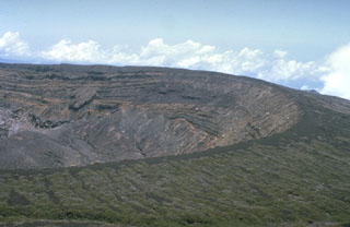 The broad summit of Santa Ana volcano has a 1.5-km-wide crater seen here from the south. The series of bedded phreatomagmatic tephra layers exposed in the crater wall in this photo form the summit region and overlie lava flows exposed lower in the crater walls.
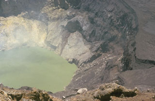 The inner crater of Santa Ana is 500 m wide and is partially filled by a 250-m-wide greenish crater lake in this 1966 photo. Fumaroles are active on the crater wall and in the lake, and abundant sulfur deposits are located on the SW wall (upper left). The acidic crater lake has a pH of about 1, and bathymetric surveys have revealed a maximum depth of 27 m.
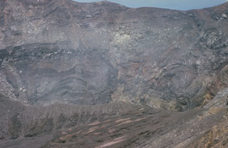 The active Santa Ana crater lies at the SE end of series of four nested summit craters and contains a small lake not visible in this photo. The northern crater wall in the background exposes a series of lava flows and inter-bedded pyroclastic deposits. Several faults are visible in the crater walls, such as the one at the upper left. Later tectonic movements produced a graben in the central part of the crater with displacements of 50-70 m.
 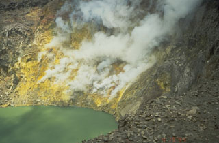 Thermal activity at the surface of a volcano is evidence of volcanic heat below. The fumarolic activity seen here produces vigorous gas-and-steam plumes along the sulfur-coated wall of the summit crater at El Salvador's Santa Ana volcano. Thermal activity is common during non-eruptive periods at many volcanoes, and may persist for many thousands of years. The interaction of high-temperature volcanic fluids and gases with groundwater in hydrothermal fields can produce geysers, hot springs, and mud pools.
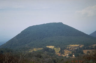 Cerro Verde is seen here from the NW above Hacienda San Blas. Three N-S-trending craters are located at the summit of Cerro Verde, and a fourth is located on the SE flank of the cone.
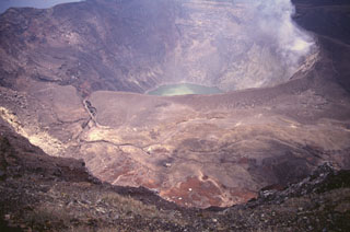 Santa Ana's active crater contains an acidic crater lake within the SE end of a series of four nested craters. This photo is taken from the northern rim of the second youngest crater and shows an older crater floor containing several small phreatomagmatic vents that formed during historical eruptions.
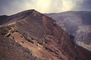 Scoria from the 1904 eruption of Santa Ana form the darker deposits across the summit crater rim. The first of two 20th-century eruptions from Santa Ana began on 12 January, lasted for about two weeks, and included phreatomagmatic explosions.
 Two volcanoes rise above the town of Juayua in western El Salvador. The peak to the left is Cerro los Naranjos, one of the youngest peaks of the Apaneca Range volcanic complex. The broader peak to the right is Santa Ana. Santa Ana has produced recent eruptions from both summit and flank vents.
 The broad summit of Santa Ana is seen here from Cerro Verde, a cone on its SSE flank. The summit has a series of four nested craters, the largest of which is 1.5 km wide. Houses of Hacienda San Blas are visible at the bottom of the photo. Much of the flanks are covered with coffee crops that are an important part of the local economy.
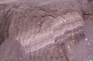 These scoria layers from Santa Ana were transported intact with only slight disruption out to about 30 km from the volcano in the Acajutla debris avalanche. A more than 20-m-thick sequence of inter-bedded tephra layers and thin lava flows within an avalanche hummock is exposed in this quarry in near Highway 2. The red-and-yellow bars on the scale mark 10-cm increments.
 The rounded vegetated peak in the background and to the left is Cerro Verde on the SSE flank of Santa Ana, to the right. The broad edifice in front of them is the Cerro la Olla-Cerro Marcelino scoria cone complex on the Santa Ana flank. Cerro Marcelino at the right side of the cone complex formed during the 1722 eruption, when the Teixcal lava flow traveled 13 km E and destroyed San Juan Tecpan village.
 The broad Santa Ana volcano is to the right, with Izalco volcano to the left in this NW-looking view from the Zapotitán basin. The cone in the center is Cerro Verde, and the smaller, low-profile scoria cone below it is Cerro Marcelino. Historical eruptions have occurred from the summit crater of Santa Ana and flank cones such as Cerro Marcelino to the SE. Izalco formed in 1770, and the saddle between Izalco and Cerro Verde increased 100 m in height in the century after 1866.
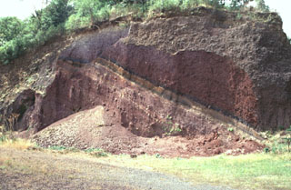 Scoria deposits are exposed in a quarry on the NE flank of Cerro Verde along the road to its summit. Cerro Verde is the largest of a chain of scoria cones on the SE flank of Santa Ana.
 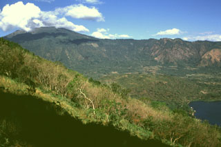 Santa Ana is seen here from the east on the rim of Coatepeque caldera. The eastern rim of Santa Ana's summit crater was breached and produced the gently sloping deposits extending towards the caldera lake to the lower right. The NW wall of the caldera in the background cuts into the flanks of Santa Ana. This SW part of Coatepeque caldera formed about 57,000 years ago during the eruption of about 16 km3 of rhyolite pumice and pyroclastic flow deposits.
 Izalco volcano was once known as the "Lighthouse of the Pacific" for its persistent incandescent nighttime eruptions. It was constructed on the southern flank of Santa Ana, whose broad summit is to the left. To the right is Cerro Verde, a scoria cone on the SE Santa Ana flank. Lava flows at the base if Izalco from both summit and flank vents and extend out to 7 km.
 Izalco has been one of El Salvador's most active volcanoes during historical time. More than 50 eruptions took place since it began to erupt in 1770, many lasting several years to about a decade in duration. Eruptions took place both from the summit craters and from flank vents. Unvegetated lava flows are seen here on the SE flank below Cerro Verde (center) and El Conejal and El Astillero (right).
 The broad E-W-trending Apaneca Range is seen here from the south with flat-topped Cerro de Apaneca on the left. The Laguna Las Ninfas -Laguna Verde complex is in the center, and to its right are Cerro Cuyanausul, Cerro los Ranas, Cerro el Aguila, and Cerro los Naranjos. The Concepción de Ataco caldera lies beyond the center horizon, behind post-caldera cones. The photo is taken from the top of a hummock on the surface of the massive Acajutla debris avalanche deposit that originated from Santa Ana volcano, which is out of view to the right.
 Santa Ana volcano, seen in the distance more than 30 km to the north, underwent catastrophic edifice collapse during the late Pleistocene. This produced a massive, highly mobile, debris avalanche that emplaced the boulders in the foreground and formed the small hummocks across the center. The larger hill to the left is composed of the older Bálsamo formation, which was surrounded by the avalanche. This avalanche was one of the largest known in Central America and traveled nearly 50 km from the volcano.
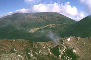 Santa Ana rises beyond the Izalco summit crater, which began erupting in 1770 on the northern Santa Ana flank. Fumarolic activity continues at Izalco, producing the faint steam plume in the right foreground, but has diminished considerably since the 200-year-long eruptive period ended in 1966. A complex of four nested craters gives the summit of Santa Ana a flat profile. The flank of Cerro Verde is seen to the right.
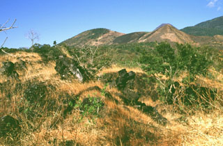 The lava flow in the foreground was erupted in 1722 from San Marcelino, the scoria cone to the right. The 13-km-long Teixcal lava flow traveled to the east and destroyed San Juan Tecpan village. The flow originated from two vents on opposite sides of San Marcelino. Cerro Chino is to the left of San Marcelino and is the central of three scoria cones along a SW trend from San Marcelino to La Olla.
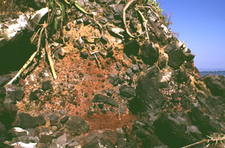 Large clasts in an oxidized scoria matrix of the Acajutla debris avalanche deposit are exposed at the Pacific Ocean coastline more than 40 km from Santa Ana volcano. Clasts with a jigsaw fracture pattern can be seen at the top of the photo and clasts at least 6 m in diameter are nearby. Note the rock hammer in the center for scale.
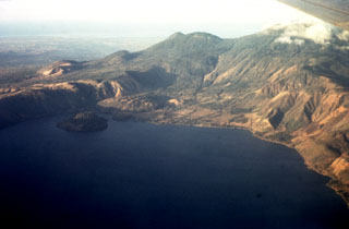 An aerial view of the western side of Coatepeque caldera shows Cerro Grande lava dome, the island to the left. On the ridge behind the caldera wall are (from left to right) the San Marcelino-Cerro la Olla and Cerro el Conejal-Cerro el Astillero complexes, the summit of Izalco volcano, rounded Cerro Verde scoria cone, and (in the clouds) the summit of Santa Ana volcano. The Pacific Ocean is visible in the distance.
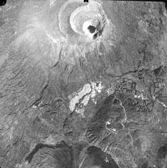 A lake fills the youngest of four nested craters of Santa Ana volcano (top center). A road winds at the lower right to radio antennas at the summit of forested Cerro Verde cinder cone, one of a series of volcanic cones constructed along a NNW-SSE-trending fissure cutting across Santa Ana. The dark unvegetated areas at the bottom of the photo are the northern flanks of Izalco volcano.
 The escarpment across the middle of the photo with vertical rows of coffee plantation trees across the scarp in is the NW wall of a large caldera formed by edifice collapse of Santa Ana volcano during the late Pleistocene. About 5 km of the scarp is exposed; the remainder is buried beneath ejecta and lava flows from modern Santa Ana volcano. Cerro los Naranjos volcano rises beyond the scarp, and other peaks of the Apaneca range form the horizon on either side.
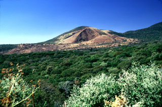 San Marcelino scoria cone (center) on the NE flank of Santa Ana was the source of a lava flow that traveled 13 km to the east (left). The 1722 lava flow originated from two vents at the eastern and western sides of San Marcelino.
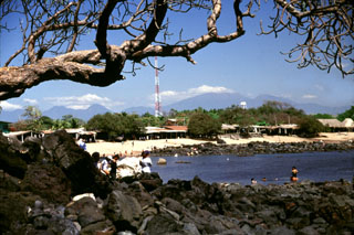 The massive Acajutla debris avalanche swept into the sea, forming a peninsula that extended the shoreline about 7 km. The rocks in the foreground and across the bay at Playa Los Cobanos are the farthest subaerial extent of the avalanche, 41 km from its source at Santa Ana volcano on the horizon to the right. Hummocks are exposed to the coastline and are visible well offshore on bathymetric surveys, which suggest that the avalanche deposit has a significant submarine component.
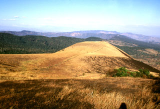 San Marcelino scoria cone is seen from Cerro Chino on the SE flank of Santa Ana. San Marcelino formed during an eruption in 1722 and produced a lava flow that traveled 13 km to the east. The vegetated southern rim of Coatepeque caldera can be seen to the NE (left) of San Marcelino.
 The brownish area extending across the center of the photo is the 1722 Teixcal lava flow. Erupting from the base of San Marcelino scoria cone on the SE flank of Santa Ana (out of view to the right), the flow traveled 13 km E to the edge of the Zapotitán basin and destroyed the village of San Juan Tecpán as well as burying about 15 km2 of agricultural land.
 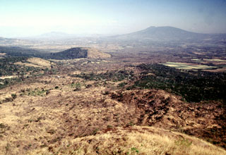 The Teixcal lava flow is the brownish area extending diagonally from the lower left towards San Salvador volcano on the right horizon. It originated during an eruption in 1722 from the base of San Marcelino scoria cone, where this photo was taken. The lava is noted for its disequilibrium textures, where large orthopyroxene crystals are surrounded by olivine reaction rims. The half-forested, half-vegetated cone near the center is Cerro Alto, a scoria cone of Coatepeque caldera (out of view to the left).
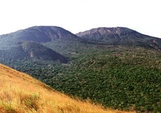 This view looking to the NW from Cerro Chino scoria cone shows some of the vents on the flank of Santa Ana, whose broad summit is to the right. The small vegetated cone in the midground to the left is Cerro el Astillero, and the larger cone behind it is Cerro Verde.
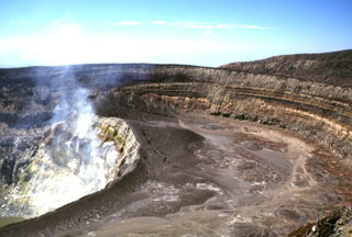 Several nested craters are found at the summit of Santa Ana. Gases rise from fumaroles on the steep NE wall of an inner crater, within a roughly 900-m-wide crater. The 80-m-high crater walls expose tephra layers from phreatomagmatic eruptions. The walls of the two outer craters, which open towards the SW, are at the upper right.
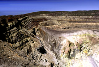 Sequences of phreatomagmatic tephra layers are exposed in the southern and western crater walls of Santa Ana. The hydrothermally altered area to the lower right is the inner crater, which contains an acidic lake not visible in this photo. Four crater walls can be seen in this photo; the two outer walls appear in the center on and below the horizon, beyond the flat rim of the inner crater.
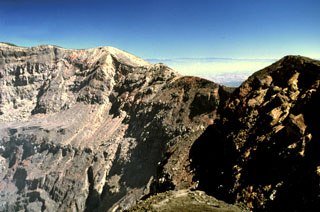 The eastern crater rim of Santa Ana rises more than 100 m above the crater floor. The eastern wall is composed of breccias, scoria units, thin lava flows, and dikes. Thick sequences of lava flows are exposed in the northern and southern crater walls and on the southern side they are overlain by phreatomagmatic tephra layers up to 100 m thick.
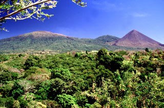 Three peaks of the Santa Ana massif can be seen from the highway between Sonsonate and San Salvador. The summit of Santa Ana volcano is to the left, the unvegetated Izalco volcano is to the right, and between them is Cerro Verde.
 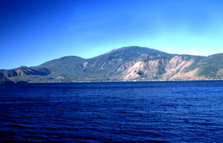 Santa Ana volcano rises above Lago de Coatepeque. The 6-km-wide lake lies at the eastern end of the Coatepeque caldera. The northern and southern rims of the western side of the caldera are visible beyond the lake. The rounded peak to the left of Santa Ana is Cerro Verde, one of many cones along a NW-SE-trending fissure cutting across the Santa Ana complex.
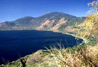 Coatepeque caldera is seen here from its northern rim, with Santa Ana volcano in the background. The caldera walls rise from 250 m to about 1 km above the lake and the stratigraphy is exposed in some areas. The rounded summit behind the caldera rim to the left is Cerro Verde, which was erupted along a NW-SE-trending fissure cutting through Santa Ana.
 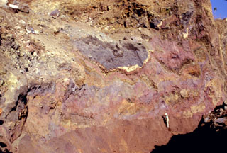 Multi-colored remnants of Santa Ana volcano are exposed in a quarry wall in a hummock of the Acajutla debris avalanche deposit with a geologist to the lower right for scale. This quarry in Cerro el Jicaro, 6 km SE of the city of Sonsonate, displays characteristic textures of debris avalanche deposits. Individual segments are faulted and slightly deformed, but retain their integrity despite being transported about 18 km from the volcano.
 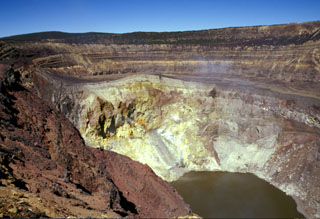 Gases rise from the hydrothermally altered western wall of Santa Ana's inner summit crater above the acidic lake. A steep path down the NE crater wall (far right) provides access to the lake for geochemical sampling. Sequences of phreatomagmatic tephra units more than 100 m thick are exposed in the walls of the outer summit craters.
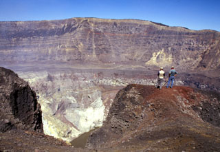 Geologists on the southern rim of Santa Ana's summit crater stand above the hydrothermally altered walls of the more than 100-m-deep inner crater. A near-vertical fault is visible in the far northern wall of the larger crater beyond the crater floor in the center of the photo, above the inner crater. Lava flows exposed in the crater wall are overlain by a roughly 10-m-thick light-brown sequence of phreatomagmatic tephra layers.
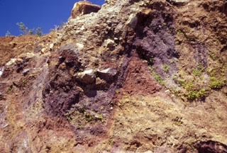 Multi-colored individual units of the Acajutla debris avalanche deposit are offset along normal faults in this view of a quarry wall 6 km SE of the city of Sonsonate. Many blocks are unfractured, and some are shattered blocks with jigsaw textures. About 8 m of the quarry wall is exposed on the right-hand side. The voluminous Acajutla avalanche deposit was produced by late-Pleistocene edifice failure of Santa Ana; this quarry lies about 18 km from the volcano.
 The escarpment cutting diagonally downward across the middle of the photo in front of conical Cerro los Naranjos volcano is the NW wall of a large late-Pleistocene caldera formed by edifice collapse of Santa Ana volcano. The exposed portion of the collapse scarp is up to about 200 m high along a roughly 5 km segment of the arcuate avalanche caldera. Pyroclastic ejecta and lava flows from modern Santa Ana volcano have filled in much of the scarp in the foreground and have buried it completely on the northern and eastern sides.
  The Acajutla Peninsula is the largest topographic irregularity along a 900-km-long stretch of the Pacific coast between the Gulf of Tehuantepec off Oaxaca, México and the Gulf of Fonseca at the SE tip of El Salvador. The 20-km-wide peninsula was created by a debris avalanche that traveled nearly 50 km following the late-Pleistocene collapse of Santa Ana volcano, located beneath the cloud bank to the right of Coatepeque lake. Part of the shallow submarine component of the deposit is visible in this International Space Station image with north to the lower left.
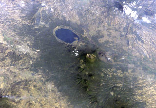 Lake-filled Coatepeque caldera is prominent in this International Space Station image with north to the lower left. A post-caldera lava dome forms an island at the SW side of the lake. The nested summit craters of Santa Ana volcano are visible below and to the right of Coatepeque, and the unvegetated cone of Izalco volcano is to the right of Santa Ana. Small stratovolcanoes of the Sierra de Apaneca form the forested ridge at the bottom right. The light-colored area at the left-center is the city of Santa Ana, the second largest in El Salvador.
 Four volcanoes in western El Salvador are visible in this Space Shuttle image. The forested ridge at the left-center is the Apaneca Range, a complex of calderas and small stratovolcanoes. The summit crater of Santa Ana volcano lies below the small cloud bank, and the brownish area below it is Izalco volcano. A circular lake partially fills Coatepeque caldera. The Acajutla Peninsula at the bottom, named after the port city of Acajutla, was formed by a massive debris avalanche produced by the late-Pleistocene collapse of Santa Ana volcano.
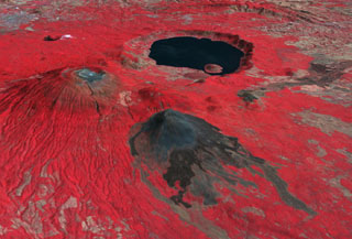 This false-color oblique DEM overlain by a thermal infrared ASTER image shows Santa Ana volcano (middle left), Izalco volcano (center), and the roughly 5.5 x 6 km Coatepeque caldera lake from the SW. The summit of Santa Ana has series of nested craters, and a NW-SE-trending fissure across the edifice. Lava flows were recently emplaced across the southern flanks of Izalco. The grayish area at the far upper left is the city of Santa Ana, El Salvador.
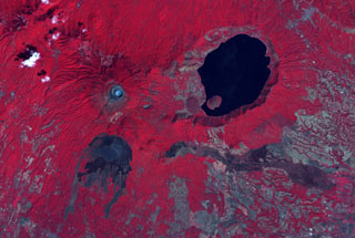 The summit crater complex of Santa Ana volcano with its small light-bluish crater lake is visible at the left-center in this false-color ASTER satellite image (N is to the top; this image is approximately 30 km across). The lake-filled Coatepeque caldera is east of Santa Ana, and Izalco volcano with its lava flows are to the south. A fissure was the source of an eruption in 1722 CE from a scoria cone (center) on the SE flank that produced the lava flow across the image to the lower right.
 The summit crater complex of Santa Ana volcano with its small crater lake is visible left of center in this NASA ASTER image (with north to the top) taken on October 10, 2005, following an explosive eruption on October 1. In this false-color image dark ashfall deposits cover otherwise reddish vegetation around the summit of the volcano and extend down its upper eastern flank. The eruption occurred just prior to heavy rainfall accompanying Hurricane Stan, and lahars swept the flanks of the volcano. The large lake at the right is Coatepeque caldera.
 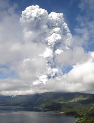 An ash-and-steam plume from Santa Ana towers above Coatepeque caldera lake. The one-hour explosive eruption the morning of 1 October 2005 produced plumes that rose 10 km or more. Ash fell in towns west of the volcano and extended into Guatemala. Volcanic blocks up to a meter in diameter fell as far as 2 km south of the summit. Lahars descended valleys on the flanks of the volcano.
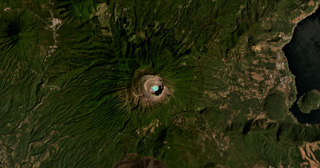 Santa Ana (or Ilamatepec) has several nested summit craters, with the active crater containing the blue lake shown in this February 2021 Planet Labs satellite image monthly mosaic (N is at the top; this image is approximately 16 km across). Several small cones have formed along the SE flank, down to the San Marcelino scoria cone that emplaced the 13-km-long lava flow eastwards in 1722. The Coatepeque Caldera is to the E and the Apaneca Range is to the W.
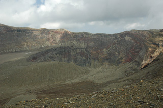 The Santa Ana crater is seen here from the western rim in 2011. Several nested craters have formed across the summit, with a crater lake in the smallest crater in the center of this photo (out of view). Exposed in the crater walls are lava flows and explosive eruption deposits that form the edifice.
 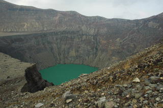 The Santa Ana crater lake is in the smallest and deepest of several nested craters across the summit that formed during successive explosive events, seen here in 2011 from the western side on the terrace level. The acid sulfate-chloride lake has a pH around 1, with an associated subsurface hydrothermal system that releases gases into the water.
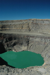 The acidic crater lake of Santa Ana is within the deepest of the nested summit craters, seen here from the S in 2011. The floor of a larger crater is visible across the center of this photo, and both lava flows and deposits from explosive eruptions are exposed in the crater walls.
 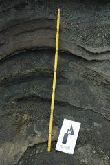 This outcrop within a barranca (ravine) on the western side of the Santa Ana summit area shows explosive deposits from the 2005, 1904, and older eruptions. The different ash and lapilli units have variable grain sizes, an indication of variations in explosivity. The yellow ruler is 72 cm long; photo taken in 2011.
There are no samples for Santa Ana in the Smithsonian's NMNH Department of Mineral Sciences Rock and Ore collection.
| Copernicus Browser | The Copernicus Browser replaced the Sentinel Hub Playground browser in 2023, to provide access to Earth observation archives from the Copernicus Data Space Ecosystem, the main distribution platform for data from the EU Copernicus missions. |
| MIROVA | Middle InfraRed Observation of Volcanic Activity (MIROVA) is a near real time volcanic hot-spot detection system based on the analysis of MODIS (Moderate Resolution Imaging Spectroradiometer) data. In particular, MIROVA uses the Middle InfraRed Radiation (MIR), measured over target volcanoes, in order to detect, locate and measure the heat radiation sourced from volcanic activity. |
| MODVOLC Thermal Alerts | Using infrared satellite Moderate Resolution Imaging Spectroradiometer (MODIS) data, scientists at the Hawai'i Institute of Geophysics and Planetology, University of Hawai'i, developed an automated system called MODVOLC to map thermal hot-spots in near real time. For each MODIS image, the algorithm automatically scans each 1 km pixel within it to check for high-temperature hot-spots. When one is found the date, time, location, and intensity are recorded. MODIS looks at every square km of the Earth every 48 hours, once during the day and once during the night, and the presence of two MODIS sensors in space allows at least four hot-spot observations every two days. Each day updated global maps are compiled to display the locations of all hot spots detected in the previous 24 hours. There is a drop-down list with volcano names which allow users to 'zoom-in' and examine the distribution of hot-spots at a variety of spatial scales. |
|
WOVOdat
Single Volcano View Temporal Evolution of Unrest Side by Side Volcanoes |
WOVOdat is a database of volcanic unrest; instrumentally and visually recorded changes in seismicity, ground deformation, gas emission, and other parameters from their normal baselines. It is sponsored by the World Organization of Volcano Observatories (WOVO) and presently hosted at the Earth Observatory of Singapore.
GVMID Data on Volcano Monitoring Infrastructure The Global Volcano Monitoring Infrastructure Database GVMID, is aimed at documenting and improving capabilities of volcano monitoring from the ground and space. GVMID should provide a snapshot and baseline view of the techniques and instrumentation that are in place at various volcanoes, which can be use by volcano observatories as reference to setup new monitoring system or improving networks at a specific volcano. These data will allow identification of what monitoring gaps exist, which can be then targeted by remote sensing infrastructure and future instrument deployments. |
| Volcanic Hazard Maps | The IAVCEI Commission on Volcanic Hazards and Risk has a Volcanic Hazard Maps database designed to serve as a resource for hazard mappers (or other interested parties) to explore how common issues in hazard map development have been addressed at different volcanoes, in different countries, for different hazards, and for different intended audiences. In addition to the comprehensive, searchable Volcanic Hazard Maps Database, this website contains information about diversity of volcanic hazard maps, illustrated using examples from the database. This site is for educational purposes related to volcanic hazard maps. Hazard maps found on this website should not be used for emergency purposes. For the most recent, official hazard map for a particular volcano, please seek out the proper institutional authorities on the matter. |
| IRIS seismic stations/networks | Incorporated Research Institutions for Seismology (IRIS) Data Services map showing the location of seismic stations from all available networks (permanent or temporary) within a radius of 0.18° (about 20 km at mid-latitudes) from the given location of Santa Ana. Users can customize a variety of filters and options in the left panel. Note that if there are no stations are known the map will default to show the entire world with a "No data matched request" error notice. |
| UNAVCO GPS/GNSS stations | Geodetic Data Services map from UNAVCO showing the location of GPS/GNSS stations from all available networks (permanent or temporary) within a radius of 20 km from the given location of Santa Ana. Users can customize the data search based on station or network names, location, and time window. Requires Adobe Flash Player. |
| DECADE Data | The DECADE portal, still in the developmental stage, serves as an example of the proposed interoperability between The Smithsonian Institution's Global Volcanism Program, the Mapping Gas Emissions (MaGa) Database, and the EarthChem Geochemical Portal. The Deep Earth Carbon Degassing (DECADE) initiative seeks to use new and established technologies to determine accurate global fluxes of volcanic CO2 to the atmosphere, but installing CO2 monitoring networks on 20 of the world's 150 most actively degassing volcanoes. The group uses related laboratory-based studies (direct gas sampling and analysis, melt inclusions) to provide new data for direct degassing of deep earth carbon to the atmosphere. |
| Large Eruptions of Santa Ana | Information about large Quaternary eruptions (VEI >= 4) is cataloged in the Large Magnitude Explosive Volcanic Eruptions (LaMEVE) database of the Volcano Global Risk Identification and Analysis Project (VOGRIPA). |
| EarthChem | EarthChem develops and maintains databases, software, and services that support the preservation, discovery, access and analysis of geochemical data, and facilitate their integration with the broad array of other available earth science parameters. EarthChem is operated by a joint team of disciplinary scientists, data scientists, data managers and information technology developers who are part of the NSF-funded data facility Integrated Earth Data Applications (IEDA). IEDA is a collaborative effort of EarthChem and the Marine Geoscience Data System (MGDS). |