Dense white plumes issue from a 10-m-diameter pit crater
On 6 March 1994, we visited Las Pilas to determine the source and nature of a dense white plume, visible for at least 10 km to the S, that rose from the upper S slope of the volcano. The plume, which smelled strongly of sulfur, emerged from the bottom of a small phreatic (?) pit crater. The crater measured roughly 10 m in diameter and 5-10 m deep. The pit walls were vertical, and the pit opening was mantled by a thin coating of native sulfur. Extensive mixing with atmospheric gases occurred before the plume rose from the pit. Immediately downslope from the crater there appeared to be bedded volcanic deposits. Their presence suggests that the pit crater was the source of numerous phreatic-phreatomagmatic explosions.
We briefly examined a large, circular phreatic pit crater 50-75 m W of the small phreatic pit. This larger crater was about 30-40 m in diameter, and roughly 30 m deep. The phreatic explosion that produced the crater must have been unusually powerful, because it disrupted several (5-7 m thick) basaltic lava flows. No fumarolic activity was observed at this crater, and we saw no evidence of surge deposits in its vicinity. A Hewlett Packard chromatograph of in-situ soils at Las Pilas yielded 0.19 and 0.21 vol. % CO2, values probably within the range of background in local volcanic soils (0.04-0.1 vol.%).
CO2 in soils at volcanic areas varies considerably, and includes some relatively high values. A preliminary survey of the literature suggests soil gas CO2 in volcanic areas ranges from ten to several-hundred times the background found in many non-volcanic areas.
Information Contacts: Cristian Lugo, Instituto Nicaraguense de Estudios Territoriales (INETER), Apartado 17610-2110, Managua, Nicaragua; Michael Conway, Andrew Macfarlane, and Peter LaFemina, Florida International Univ (FIU), Miami, FL 33199 USA; John B. Murray, Ben van Wyk de Vries, and Adam Maciejewski, Open Univ, Milton Keynes, MK7 6AA, U.K..
The Global Volcanism Program has no Weekly Reports available for Las Pilas-El Hoyo Complex.
Reports are organized chronologically and indexed below by Month/Year (Publication Volume:Number), and include a one-line summary. Click on the index link or scroll down to read the reports.
Minor fumarolic activity
Minor fumarolic activity continued in June, and an area of recently-killed vegetation was observed on the NNE flank. The Las Pilas complex last erupted 29-31 October 1954, producing explosions from the central crater El Hoyo.
Information Contacts: R. Stoiber and S. Williams, Dartmouth College; M. Carr and J. Walker, Rutgers Univ.; A. Creusot, Instituto Nicaraguense de Energía.
Small vapor plume
In late 1980 a small continuous vapor plume was still being emitted from the top of the kilometer-long crack in the summit.
Information Contacts: R. Stoiber, S. Williams, H.R. Naslund, L. Malinconico, and M. Conrad, Dartmouth College; A. Aburto, D. Fajardo B., Instituto de Investigaciones Sísmicas.
Gas emission continuing from 1952 fissure
The [summit-area] fissure formed in the 1952 eruption was still emitting gas on 16 January 1988. Another small eruption was reported in 1954.
Information Contacts: B. van Wyk de Vries, H. Rymer, and G. Brown, Open Univ; P. Hradecky and H. Taleno, INETER.
Fumarolic activity
An 8-14 µm infrared thermometer was used on 23 April to measure temperatures of the inner wall of the prominent 20-m-deep chasm formed in the [1952] eruption. Weak fumarolic activity was occurring there, and the maximum recorded temperature was 96°C, probably corresponding closely with the gas temperature.
Information Contacts: C. Oppenheimer, Open Univ; B. van Wyk de Vries, INETER.
Continued fumarolic activity; many young prehistoric lava flows
"The El Hoyo fumarole was visited 3 times (15:04) and showed no discernable change from wet- to dry-season conditions (98°C). There is no other strong thermal activity in the summit region of El Hoyo.
"The central crater walls of El Hoyo (150 m deep) are composed of lava and agglutinated spatter, probably produced by Hawaiian activity (figure 1). In contrast, Las Pilas, Asososca, and Cerro Negro are predominantly scoria cones formed by Strombolian eruptions. All vents have produced extensive lava flows. Poorly vegetated flows extend up to 15 km from both Las Pilas and El Hoyo and are probably less than a few thousand years old."
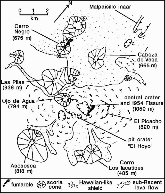 |
Figure 1. Sketch map of the El Hoyo volcanic complex and Cerro Negro. After Bice (1980). |
Reference. Bice, D.C., 1980, Tephra stratigraphy and physical aspects of recent volcanism near Managua, Nicaragua: Ph.D. Dissertation, Univ of California, Berkeley, 422 p.
Information Contacts: B. van Wyk de Vries, O. Castellón, A. Murales, and V. Tenorio, INETER.
Small gas plume
A persistent, very small gas plume was visible in late April, rising from the NE margin of the 1-km fissure formed in 1952. Weak activity has been reported from this fumarole since 1980.
Information Contacts: S. Williams, Arizona State Univ.
Weak fumarolic activity
El Hoyo's main fumarole was emitting vapor at usual levels on 6-7 January.
Information Contacts: Andrea Borgia, Instituto Nazionale di Geofisica, via di Vigna Murata 605, 00143 Roma, Italy; B. van Wyk de Vries, Open Univ; Peter J. Baxter, Dept of Community Medicine, Fenner's, Gresham Road, Cambridge, England.
Weak fumarolic activity
A continuous white plume from El Hoyo was easily visible at distances of 5-10 km from the volcano throughout the entire first week of September.
Information Contacts: Michael Conway and Andrew Macfarlane, FIU; Charles Connor, CNWA Bldg. 168, Southwest Research Institute, 6220 Culebra Road, San Antonio, TX 78228-0510; Oscar Leonel Urbina and Cristian Lugo, INETER.
Dense white plumes issue from a 10-m-diameter pit crater
On 6 March 1994, we visited Las Pilas to determine the source and nature of a dense white plume, visible for at least 10 km to the S, that rose from the upper S slope of the volcano. The plume, which smelled strongly of sulfur, emerged from the bottom of a small phreatic (?) pit crater. The crater measured roughly 10 m in diameter and 5-10 m deep. The pit walls were vertical, and the pit opening was mantled by a thin coating of native sulfur. Extensive mixing with atmospheric gases occurred before the plume rose from the pit. Immediately downslope from the crater there appeared to be bedded volcanic deposits. Their presence suggests that the pit crater was the source of numerous phreatic-phreatomagmatic explosions.
We briefly examined a large, circular phreatic pit crater 50-75 m W of the small phreatic pit. This larger crater was about 30-40 m in diameter, and roughly 30 m deep. The phreatic explosion that produced the crater must have been unusually powerful, because it disrupted several (5-7 m thick) basaltic lava flows. No fumarolic activity was observed at this crater, and we saw no evidence of surge deposits in its vicinity. A Hewlett Packard chromatograph of in-situ soils at Las Pilas yielded 0.19 and 0.21 vol. % CO2, values probably within the range of background in local volcanic soils (0.04-0.1 vol.%).
CO2 in soils at volcanic areas varies considerably, and includes some relatively high values. A preliminary survey of the literature suggests soil gas CO2 in volcanic areas ranges from ten to several-hundred times the background found in many non-volcanic areas.
Information Contacts: Cristian Lugo, Instituto Nicaraguense de Estudios Territoriales (INETER), Apartado 17610-2110, Managua, Nicaragua; Michael Conway, Andrew Macfarlane, and Peter LaFemina, Florida International Univ (FIU), Miami, FL 33199 USA; John B. Murray, Ben van Wyk de Vries, and Adam Maciejewski, Open Univ, Milton Keynes, MK7 6AA, U.K..
|
|
||||||||||||||||||||||||||
There is data available for 3 confirmed eruptive periods.
1954 Oct 29 - 1954 Oct 31 Confirmed Eruption (Explosive / Effusive) VEI: 2
| Episode 1 | Eruption (Explosive / Effusive) | El Hoyo | |||||||||||||||||||||||
|---|---|---|---|---|---|---|---|---|---|---|---|---|---|---|---|---|---|---|---|---|---|---|---|---|
| 1954 Oct 29 - 1954 Oct 31 | Evidence from Observations: Reported | |||||||||||||||||||||||
|
List of 3 Events for Episode 1 at El Hoyo
|
||||||||||||||||||||||||
1952 Oct 23 - 1952 Dec 16 ± 15 days Confirmed Eruption (Explosive / Effusive) VEI: 1
| Episode 1 | Eruption (Explosive / Effusive) | El Hoyo | |||||||||||||||||||||||
|---|---|---|---|---|---|---|---|---|---|---|---|---|---|---|---|---|---|---|---|---|---|---|---|---|
| 1952 Oct 23 - 1952 Dec 16 ± 15 days | Evidence from Observations: Reported | |||||||||||||||||||||||
|
List of 3 Events for Episode 1 at El Hoyo
|
||||||||||||||||||||||||
1528 Confirmed Eruption (Explosive / Effusive)
| Episode 1 | Eruption (Explosive / Effusive) | Volcano Uncertain | |||||||||||||
|---|---|---|---|---|---|---|---|---|---|---|---|---|---|---|
| 1528 - Unknown | Evidence from Unknown | |||||||||||||
|
List of 1 Events for Episode 1 at Volcano Uncertain
|
||||||||||||||
This compilation of synonyms and subsidiary features may not be comprehensive. Features are organized into four major categories: Cones, Craters, Domes, and Thermal Features. Synonyms of features appear indented below the primary name. In some cases additional feature type, elevation, or location details are provided.
Cones |
||||
| Feature Name | Feature Type | Elevation | Latitude | Longitude |
| Asososca, Cerro | Stratovolcano | 818 m | 12° 27' 7.00" N | 86° 40' 30.00" W |
| Cabeza de Vaca, Cerro | Pyroclastic cone | 866 m | 12° 30' 47.00" N | 86° 40' 52.00" W |
| Grande, Cerro | Cone | 1001 m | 12° 30' 0.00" N | 86° 41' 0.00" W |
| Hoyo, Volcán el | Stratovolcano | |||
| Ojo de Agua, Cerro | Pyroclastic cone | 900 m | 12° 29' 20.00" N | 86° 41' 13.00" W |
| Picacho, El | Stratovolcano | 879 m | 12° 29' 42.00" N | 86° 39' 18.00" W |
| Santa Matilde | Pyroclastic cone | 381 m | ||
| Tacanistes, Cerro | Cone | 512 m | 12° 28' 0.00" N | 86° 38' 49.00" W |
Craters |
||||
| Feature Name | Feature Type | Elevation | Latitude | Longitude |
| Asososca, Laguna de
Axusco |
Maar | 255 m | 12° 25' 59.00" N | 86° 39' 47.00" W |
| Joya, La | Maar | 222 m | 12° 33' 0.00" N | 86° 40' 30.00" W |
| Malpasillo | Maar | |||
| Picacho, Caldera el | Caldera | |||
| Seca, Laguna
Sabanetas, Las |
Maar | 12° 22' 37.00" N | 86° 39' 7.00" W | |
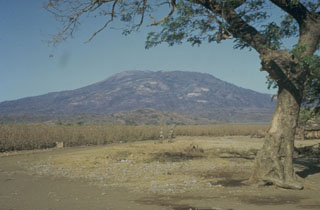 Las Pilas stratovolcano, seen here from the S, is the most prominent feature of Nicaragua's Las Pilas volcanic complex. Las Pilas rises to 900 m above its base in the Nicaraguan depression. Its broad summit contains a 700-m-wide crater and a N-S fissure that formed during an eruption in 1952.
  The southern side of Las Pilas volcano is cut by a prominent transverse fissure, seen steaming in this 1970 view from the SW. A small circular pit crater, El Oyo, is located above the fissure just below the crater rim. Aside from a possible eruption in the 16th century, the only historical eruptions of Las Pilas took place in the 1950s from a fissure that extended across the east side of the 700-m-wide summit crater and down the north flank.
 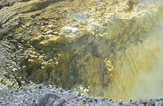 Precipitated sulfur lines the walls of a transverse fracture cutting the upper southern flank of Las Pilas volcano. The fissure extends from the upper SE flank to El Oyo pit crater on the upper SW flank. Fumaroles are particularly active at the SE end of the fissure.
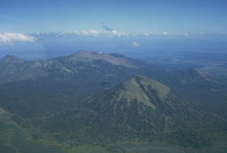 Las Pilas volcanic complex includes a cluster of cones, of which Las Pilas (El Hoyo), in the center background, is the largest. A N-S fracture system cutting across the cone has produced numerous well-preserved flank vents, including maars. Cerro Asososca is the prominent conical volcano in the right foreground of this photo from the SW. Cerro Grande is the peak at the upper left. The only certain historical eruptions of Las Pilas took place in the 1950s from a fissure that cut across the summit east of the 700-m-wide summit crater.
  The summit crater of Las Pilas volcano is 700 m wide and 120 m deep. Concentric fissures illustrate its collapse origin. Steam rises from fumaroles along a transverse fissure that extends from the lower right to the upslope (northern) side of the dramatic El Hoyo pit crater at the lower left.
 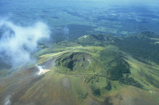 The summit crater of Las Pilas volcano (also known as El Hoyo) is 700 m wide and about 120 m deep. A prominent fumarole on the SE side of the crater emits a steam plume. Beyond and to the right of Las Pilas is the 900-m-high satellitic cone Cerro Ojo de Agua, itself capped with a 400-m-wide crater. The diagonal line cutting across from the summit crater of Las Pilas to the lower right was formed during an eruption in 1952.
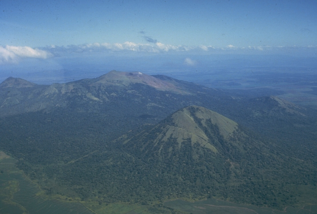
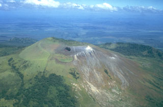 Las Pilas volcano is seen here in an aerial view from the south, with the dramatic El Hoyo pit crater below the summit at the left center. The arcuate ridge at the right beyond Las Pilas is the NE rim of a large crater cutting the older Cerro el Picacho volcano. The flat area in the background beyond Cerro el Picacho on the floor of the Nicaraguan depression is the Malpaisillo pyroclastic shield volcano.
 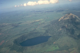 The lake-filled Laguna de Asososca maar in the foreground and the Cerro Asososca cone to the right were formed by eruptions at the southern end of a N-S fissure system of the Las Pilas volcanic complex in Nicaragua. The ages of these vents are not known. This view looks from the NE across the broad plain at the foot of the Cordillera de los Maribios to the Pacific Ocean in the distance.
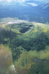 The 1-km-long fissure that reaches from the lower left across the summit crater of Las Pilas was formed during an eruption in 1952. The eruption, which began on October 23, produced ash-bearing steam clouds that ejected fragments of rock from the walls of the new fissure. The eruption ended in December. This view from the north shows the undated Laguna de Asososca maar (upper right), which was formed near the southern end of the fissure system cutting across Las Pilas volcanic complex.
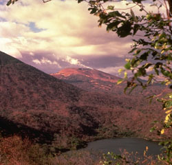 Las Pilas volcano (center), with a steam plume pouring from a vigorous fumarole on the SE side of the summit, is viewed here from the south rim of Laguna de Asososca, a 1.3 x 2 km wide maar on the southern end of Las Pilas volcanic complex. The surface of Laguna de Asososca is less than 100 m above sea level. At the left is the eastern flank of Cerro Asososca stratovolcano.
 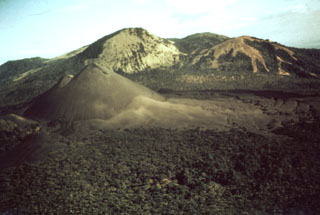 Cerro Negro, the unvegetated cinder cone at the left center, was born on April 13, 1850 on an uninhabited plain between Las Pilas (in the background) and Rota volcanoes. The new cone reached a height of 50-60 m in ten days, after which activity subsided until renewing on May 27. The tephra-mantled lava flow in the middle of the photo, extending from the western base of the cone to the forest in the foreground, was erupted in 1850. The Las Pilas volcanic complex includes the peaks of Cerro Grande, Las Pilas itself, and Cerro Ojo de Agua.
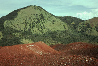 The vegetated peak Cerro Grande, a satellitic cone lying on the NW side of Las Pilas volcanic complex, rises to the SE above the reddish surface of Cerro Negro volcano in the foreground. At 1001 m, Cerro Grande is the second highest peak of the N-S-trending Las Pilas volcanic complex.
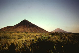 Two conical peaks of differing age rise to the east above the floor of the Nicaraguan depression. Cerro Asososca (left), part of Las Pilas volcanic complex, was constructed along a fissure extending south from Las Pilas. Erosional gullies cut the flanks of the 818-m-high cone. In the distance to the right is the younger Momotombo volcano, frequently active during historical time.
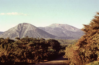 Two dramatically different volcano morphologies are visible in this photo of Las Pilas volcanic complex. Conical 818-m-high Asososca stratovolcano (left foreground) has a pronounced erosional valley on its southern flank. Broad Las Pilas volcano (right background) rises to 1088 m and has a more complex volcanic history. These are the two most prominent of a roughly 30-km-long chain of N-S-trending vents.
 The flat light-colored area at the top of the photo beyond Las Pilas volcano in the foreground is the Malpaisillo caldera. This large but topographically indistinct pyroclastic shield volcano lies in the Nicaraguan depression NE of Las Pilas volcano and NNW of Momotombo volcano. Formation of the 10-km-wide Malpaisillo caldera produced extensively dissected dacitic airfall and ignimbrite deposits that extend across the graben east of the Marrabios Range and reach into Lake Managua to the SE.
 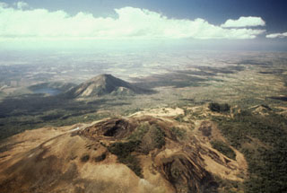 Volcán Las Pilas lies in the foreground in this aerial view of Las Pilas volcanic complex from the north. The diagonal line cutting across from left of the summit crater to the bottom center is the fissure from the 1952 eruption. The forested crater at the middle right is Cerro Ojo de Agua. The conical peak in the middle distance is Cerro Asososca, and immediately to its left is Laguna de Asososca maar. Two other dry maars are located in the Nicaraguan depression between Laguna de Asososca and the tip of Lake Managua at the upper left.
 Las Pilas volcano (right center) rises above a cattle ranch on its SE side. The rounded eroded peak at the left is the older cone of Cerro Los Tacanistes. The floor of the Nicaraguan depression at this point is less than 100 m above sea level, a full kilometer below the summit of Las Pilas.
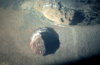 This dramatic near-vertical aerial photo looks down on El Hoyo, a spectacular pit crater near the summit of Las Pilas volcano. The pit crater, approximately 100 m in diameter, was formed by collapse. El Hoyo is located immediately south of the rim of the 700-m-wide summit crater of Las Pilas (upper right).
 An aerial view to the NW looks down the spine of the Marrabios Range, which rises above the floor of the Nicaraguan depression. In the foreground is Momotombo volcano, which rises to 1297 m above the shores of Lake Managua (left). Monte Galán caldera lies beyond the right-hand flanks of Momotombo. Stretching across much of the photo beyond Momotombo is the N-S-trending Las Pilas complex, and the conical peak in the far distance is San Cristóbal volcano.
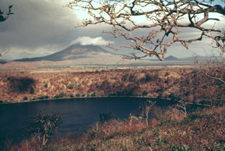 Laguna de Asososca in the foreground is a maar that was constructed along a fissure extending south from Las Pilas volcano. The maar is elongated N-S in the direction of the fissure system and is about 2 km long in that direction. Prevailing winds to the west constructed a higher rim on that side, the vantage point of this photo. The cloud-capped conical peak in the distance is Momotombo, and the much lower peak to its right is Momotombito, which forms an island in Lake Managua.
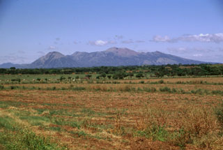 Las Pilas volcanic complex forms a broad massif seen here from the SSE rising above the Nicaraguan depression. This 30-km-long chain was erupted along a N-S-trending fissure and includes (from left to right) conical Asososca volcano, flat-topped Cerro Los Tacanistes, the unforested summit of Las Pilas itself (the high point of the range), and Cerro El Picacho.
There are no samples for Las Pilas-El Hoyo Complex in the Smithsonian's NMNH Department of Mineral Sciences Rock and Ore collection.
| Copernicus Browser | The Copernicus Browser replaced the Sentinel Hub Playground browser in 2023, to provide access to Earth observation archives from the Copernicus Data Space Ecosystem, the main distribution platform for data from the EU Copernicus missions. |
| MIROVA | Middle InfraRed Observation of Volcanic Activity (MIROVA) is a near real time volcanic hot-spot detection system based on the analysis of MODIS (Moderate Resolution Imaging Spectroradiometer) data. In particular, MIROVA uses the Middle InfraRed Radiation (MIR), measured over target volcanoes, in order to detect, locate and measure the heat radiation sourced from volcanic activity. |
| MODVOLC Thermal Alerts | Using infrared satellite Moderate Resolution Imaging Spectroradiometer (MODIS) data, scientists at the Hawai'i Institute of Geophysics and Planetology, University of Hawai'i, developed an automated system called MODVOLC to map thermal hot-spots in near real time. For each MODIS image, the algorithm automatically scans each 1 km pixel within it to check for high-temperature hot-spots. When one is found the date, time, location, and intensity are recorded. MODIS looks at every square km of the Earth every 48 hours, once during the day and once during the night, and the presence of two MODIS sensors in space allows at least four hot-spot observations every two days. Each day updated global maps are compiled to display the locations of all hot spots detected in the previous 24 hours. There is a drop-down list with volcano names which allow users to 'zoom-in' and examine the distribution of hot-spots at a variety of spatial scales. |
|
WOVOdat
Single Volcano View Temporal Evolution of Unrest Side by Side Volcanoes |
WOVOdat is a database of volcanic unrest; instrumentally and visually recorded changes in seismicity, ground deformation, gas emission, and other parameters from their normal baselines. It is sponsored by the World Organization of Volcano Observatories (WOVO) and presently hosted at the Earth Observatory of Singapore.
GVMID Data on Volcano Monitoring Infrastructure The Global Volcano Monitoring Infrastructure Database GVMID, is aimed at documenting and improving capabilities of volcano monitoring from the ground and space. GVMID should provide a snapshot and baseline view of the techniques and instrumentation that are in place at various volcanoes, which can be use by volcano observatories as reference to setup new monitoring system or improving networks at a specific volcano. These data will allow identification of what monitoring gaps exist, which can be then targeted by remote sensing infrastructure and future instrument deployments. |
| Volcanic Hazard Maps | The IAVCEI Commission on Volcanic Hazards and Risk has a Volcanic Hazard Maps database designed to serve as a resource for hazard mappers (or other interested parties) to explore how common issues in hazard map development have been addressed at different volcanoes, in different countries, for different hazards, and for different intended audiences. In addition to the comprehensive, searchable Volcanic Hazard Maps Database, this website contains information about diversity of volcanic hazard maps, illustrated using examples from the database. This site is for educational purposes related to volcanic hazard maps. Hazard maps found on this website should not be used for emergency purposes. For the most recent, official hazard map for a particular volcano, please seek out the proper institutional authorities on the matter. |
| IRIS seismic stations/networks | Incorporated Research Institutions for Seismology (IRIS) Data Services map showing the location of seismic stations from all available networks (permanent or temporary) within a radius of 0.18° (about 20 km at mid-latitudes) from the given location of Las Pilas-El Hoyo Complex. Users can customize a variety of filters and options in the left panel. Note that if there are no stations are known the map will default to show the entire world with a "No data matched request" error notice. |
| UNAVCO GPS/GNSS stations | Geodetic Data Services map from UNAVCO showing the location of GPS/GNSS stations from all available networks (permanent or temporary) within a radius of 20 km from the given location of Las Pilas-El Hoyo Complex. Users can customize the data search based on station or network names, location, and time window. Requires Adobe Flash Player. |
| DECADE Data | The DECADE portal, still in the developmental stage, serves as an example of the proposed interoperability between The Smithsonian Institution's Global Volcanism Program, the Mapping Gas Emissions (MaGa) Database, and the EarthChem Geochemical Portal. The Deep Earth Carbon Degassing (DECADE) initiative seeks to use new and established technologies to determine accurate global fluxes of volcanic CO2 to the atmosphere, but installing CO2 monitoring networks on 20 of the world's 150 most actively degassing volcanoes. The group uses related laboratory-based studies (direct gas sampling and analysis, melt inclusions) to provide new data for direct degassing of deep earth carbon to the atmosphere. |
| Large Eruptions of Las Pilas-El Hoyo Complex | Information about large Quaternary eruptions (VEI >= 4) is cataloged in the Large Magnitude Explosive Volcanic Eruptions (LaMEVE) database of the Volcano Global Risk Identification and Analysis Project (VOGRIPA). |
| EarthChem | EarthChem develops and maintains databases, software, and services that support the preservation, discovery, access and analysis of geochemical data, and facilitate their integration with the broad array of other available earth science parameters. EarthChem is operated by a joint team of disciplinary scientists, data scientists, data managers and information technology developers who are part of the NSF-funded data facility Integrated Earth Data Applications (IEDA). IEDA is a collaborative effort of EarthChem and the Marine Geoscience Data System (MGDS). |

