Report on Spurr (United States) — 13 August-19 August 2025
Smithsonian Institution / US Geological Survey
Weekly Volcanic Activity Report, 13 August-19 August 2025
Managing Editor: Sally Sennert.
Please cite this report as:
Global Volcanism Program, 2025. Report on Spurr (United States) (Sennert, S, ed.). Weekly Volcanic Activity Report, 13 August-19 August 2025. Smithsonian Institution and US Geological Survey.
Spurr
United States
61.299°N, 152.251°W; summit elev. 3374 m
All times are local (unless otherwise noted)
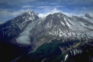
The Alaska Volcano Observatory (AVO) reported that over the past several months Spurr had exhibited decreasing signs of volcanic unrest, including small earthquakes, gas emissions, melting ice, and surface changes. Ground deformation had not been detected since March 2025. The data suggested that movement of magma toward the surface, which began in early 2024, had stopped. At 1007 on 20 August the Volcano Alert Level was lowered to Normal (the lowest level on a four-level scale) and the Aviation Color Code was lowered to Green (the lowest level on a four-color scale).
Geological Summary. Mount Spurr is the closest volcano to Anchorage, Alaska (130 km W) and just NE of Chakachamna Lake. The summit is a large lava dome at the center of a roughly 5-km-wide amphitheater open to the south formed by a late-Pleistocene or early Holocene debris avalanche and associated pyroclastic flows that destroyed an older edifice. The debris avalanche traveled more than 25 km SE, and the resulting deposit contains blocks as large as 100 m in diameter. Several ice-carved post-collapse cones or lava domes are present. The youngest vent, Crater Peak, formed at the southern end of the amphitheater and has been the source of about 40 identified Holocene tephra layers. Eruptions from Crater Peak in 1953 and 1992 deposited ash in Anchorage.
Source: US Geological Survey Alaska Volcano Observatory (AVO)