Report on Santa Maria (Guatemala) — 13 August-19 August 2025
Smithsonian Institution / US Geological Survey
Weekly Volcanic Activity Report, 13 August-19 August 2025
Managing Editor: Sally Sennert.
Please cite this report as:
Global Volcanism Program, 2025. Report on Santa Maria (Guatemala) (Sennert, S, ed.). Weekly Volcanic Activity Report, 13 August-19 August 2025. Smithsonian Institution and US Geological Survey.
Santa Maria
Guatemala
14.757°N, 91.552°W; summit elev. 3745 m
All times are local (unless otherwise noted)
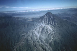
The Instituto Nacional de Sismología, Vulcanología, Meteorología e Hidrología (INSIVUMEH) reported high levels of ongoing eruptive activity at Santa Maria’s Santiaguito dome complex during 12-19 August, with continuing lava extrusion at Caliente dome. Daily explosions, 1-2 per hour when reported, generated gas-and-ash plumes that rose 800-900 m above the dome and drifted W and SW. Effusion of blocky lava and collapses of previous deposits produced block avalanches that descended mainly the W and SW flanks; the collapsed material produced short pyroclastic flows that descended the SW and S flanks during 12-13 August. Incandescence during dark hours was visible from Caliente dome and block avalanches. During the early afternoon of 12 August heavy rainfall generated lahars in the Tambor drainage (SSW) that carried blocks up to 1 m in diameter mixed with fine sediment, tree trunks, and branches. The lahars were hot and had a sulfur odor. Material accumulated at the W crater rim began collapsing at 1630 on 16 August, generating pyroclastic flows that descended the San Isidro drainage as far as 4 km. Associated gas-and-ash plumes rose 1 km and drifted 30-60 km W and SW, causing abundant ashfall in San Marcos Palajunoj (8 km SW), Loma Linda (7 km W), San Martín Sacatepéquez (11 km NW), and Colomba (18 km WSW) and minor ashfall in more distance areas including La Reforma (28 km WNW), El Quetzal (26 km WNW), Coatepeque (31 km W), and Pajapita (50 km W). In the early evening of 16 August minor lahars descended the Zanjón Seco (SW) and Tambor River channels.
Geological Summary. Symmetrical, forest-covered Santa María volcano is part of a chain of large stratovolcanoes that rise above the Pacific coastal plain of Guatemala. The sharp-topped, conical profile is cut on the SW flank by a 1.5-km-wide crater. The oval-shaped crater extends from just below the summit to the lower flank, and was formed during a catastrophic eruption in 1902. The renowned Plinian eruption of 1902 that devastated much of SW Guatemala followed a long repose period after construction of the large basaltic andesite stratovolcano. The massive dacitic Santiaguito lava-dome complex has been growing at the base of the 1902 crater since 1922. Compound dome growth at Santiaguito has occurred episodically from four vents, with activity progressing E towards the most recent, Caliente. Dome growth has been accompanied by almost continuous minor explosions, with periodic lava extrusion, larger explosions, pyroclastic flows, and lahars.
Source: Instituto Nacional de Sismologia, Vulcanologia, Meteorologia, e Hidrologia (INSIVUMEH)